Datasheet
Year, pagecount:2012, 52 page(s)
Language:English
Downloads:2
Uploaded:June 08, 2023
Size:2 MB
Institution:
-
Comments:
dreamyachtcharter.com
Attachment:-
Download in PDF:Please log in!
Comments
No comments yet. You can be the first!Most popular documents in this category


Content extract
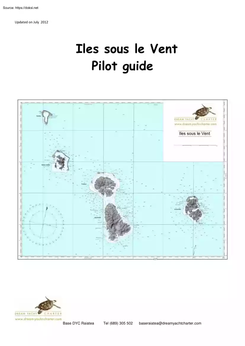
Updated on July 2012 Iles sous le Vent Pilot guide Base DYC Raiatea Tel (689) 305 502 baseraiatea@dreamyachtcharter.com Pre-Cruise Information MAEVA! Welcome to the beautiful cruising grounds of the Iles sous le vent, or The Leeward Islands. The following information will answer many of the questions you might have about the area you will be visiting. This guide is often updated so ask for the last electronic version at the base (one of the good reasons to bring a laptop)with a pen drive or email request. The base can also provide you the local charts on pdf file for further printings. For further touristic information, we recommend the website www.tahitiguidecom The Dream Yacht Tahiti Team Dream Yacht Tahiti Marina dUturoa Raiatea tel 689 66 18 80 fax 689 66 18 76 mobile : Jerome 689 305 502 email : baseraiatea@dreamyachtcharter.com skype dyraiatea www.dreamyachtchartercom Internet Communication You can call outside Polynesia from any island at the local post office.
Tikiphone is the only provider of mobile telephone communications in French Polynesia. Its network, called VINI, operates a GSM 900 MHZ network in the Society Islands, Tuamotu, Austral and Marquesas islands. So, bring your own GSM mobile phone along or rent one from the base ( around 20 Euros/week). Before leaving your country, call your phone provider’s Customer Service to make sure you have the International option. Upon your arrival in Tahiti, you will just need to switch on your mobile phone - you will see Base DYC Raiatea the "F VINI" displayed on the screen which means you are connected to Vini network. If your operator is not in the list of Vinis international partners, youll just have to purchase a local temporary prepaid VINI CARD (sold at the Tahiti Faaa airport or in Papeete) which you will insert inside your mobile phone. You can renew this card by buying a VINI CARD recharge card among the 150 retailing shops in French Polynesia. This subscription will assign
you a temporary phone number (valid 3 months), supply you with voice mail and let you call anywhere. Be aware however, that given the rates to call abroad, it is better to receive calls than to make them. It is an ideal way to keep in touch with your friends and family back home. but use it cautiously In the islands dial only the 6 numbers: i.e 305 502 for the base manager. The more comfortable access to internet in the islands is a 3G plug (or a sim card for I phone or I pad) that provide internet on your own laptop using the GSM mobile network : book it in advance at the DYC base. (Around 40 Euros/week, ideal to catch the weather forecasts and emails, again one of the good reasons to bring a laptop. There are 3 wifi service providers with access spots in the islands: Iaoranet: ww.iaoranetpf Hot spot: www.wifitikicom Mana : www.manapf Tel (689) 305 502 Airline baggage baseraiatea@dreamyachtcharter.com Excess luggage charge could be very expensive, especially on the small
planes between Papeete and Raiatea or the other islands. Please limit yourself to two bags per person as light as possible. If you are over the limit you may have to pay excess baggage charges on the small carrier serving Raiatea. The island people are quite modest and dress up when going to church. Ladies wear dresses and gentlemen wear long pants and a nice shirt Currency Central Pacific Franc (CFP or XPF) is the local money (fixed rate with Euros: 1 euros = 119.33 CFP) Credit cards are widely accepted except by small businesses and restaurants. Amex are not accepted in many places including the Dream yacht office, Visa MasterCard preferred. Most bank cards work at the banks’ ATM machines, but it is often a good idea to notify your bank at home of your departure to French Polynesia. Airlines company contacts Air Tahiti Nui Tel: (689) 46 03 03 Fax: (689) 46 02 22 Email : reservations@airtahitinui.pf Web : www.airtahitinuicom Air Tahiti (689) 86 42 42 Documents A valid passport
is required to enter Tahiti. No visas are required for American, Australian, British or European citizens for a stay of less than 30 days. Citizens of other countries should check your Airline Company or ask their local French Consulate. Bank hours Bank of Tahiti 0745-1145 & 1400-1600 Bank of Polynesia 0730-1145 & 1400-1600 Bank of Socredo 0730-1500 Arrival in Raiatea Should you require transfers from the Airport to the Dream Yacht Charter base, please don’t hesitate to contact us or ask your agent. In case of an early flight, ask the taxi to bring you to the hotel Hawaiki Nui for a breakfast at the swimming pool. You baggage can be stored at the base If your Air Tahiti flight is delayed or re-scheduled, please call us so we can prepare your arrival and reschedule your transfer. At the marina you will have ample time to stow your luggage and provisions before commencing a boat check-out and chart briefing. Emergency Phone Numbers: Raiatea 66 31 07 Gendarmerie/ police
station Bora Bora Huahine Tahaa 67 70 58 68 82 61 65 64 07 Raiatea 66 35 03 Hospital Bora Bora Huahine Tahaa 67 70 77 68 82 18 65 63 31 Fishing Gear & Kayaks Churches Protestant church Catholic Church Sunday Saturday Sunday 1000-1100 1800-1900 0800-0900 Base DYC Raiatea A limited number of kayaks and Fishing rods are available for rent at our marina. It is advisable to book them by contacting us or your agent at least few weeks in advance Fishing gear if available for hire Tel (689) 305 502 baseraiatea@dreamyachtcharter.com through Dream Yacht Charter. During your passage between the islands you will find tuna, mahi-mahi and thazards, which can be caught and they are all good to eat. Do not eat any coral fish as they could be poi- Uturoa is the best place for self provisioning with a morning market and 3 minimarkets (One open on Sunday mornings) Re-provisioning: Please try to reprovision on a weekday as it is difficult to find fresh produce on the weekend. Call the
Dream Yacht Charter base at least one day before you intend to pick up your supplies so that all will be prepared on your arrival at the marina. Scuba Diving sonous (Ciguatera). Medical There is a pharmacy on each of the Leeward Islands except for Tahaa where there is only a small clinic and a doctor. In Raiatea there are three private doctors and a regional hospital. In Huahine and Bora Bora there is a free health center. Hospitals are open 24 hours a day. Free health center hours are from 0730 to 1200 and 1400 to 1730 during the week. Saturday hours are from 0730 to 1130 Be sure to bring any necessary prescription drugs with you. Bring your SCUBA certification card , your mask, stab and regulator. We can help you organize your dives Some dive shop will allow you to rent the equipment if you have the proper certification and plan to dive with two or more people. Contact Jean Pierre et Valoux, Niyaty 689 791054 www.niyaty-plongeecom HemisphereSub, Farid or Julien at
hemissubdiving@mail.pf tel 689 72 19 52 There are scuba diving companies on Raiatea, Tahaa, Bora Bora and Huahine. Visit this site http://www.tahiti-divingcom for all info on diving the ISLV. Provisioning Things to bring Provisioning in Polynesia is expensive and selfprovisioning can be a waste of your precious charter time. We recommend that you pre-order your provisioning - just send us the completed list, we will take care of the shopping and have it stowed onboard the yacht on the day of your arrival. Vegetables: try to fit your meals with the local products; potatoes do not grow up in the islands, but excellent papayas and local roots. Sea food: Buy your fish, crabs and lobsters direct from the fishermen when possible (like on the dock near by the DYC base: Elise tel 79 28 87 or in Fare). Wave the fishermen when you see some at sea, they will be happy to sell you their catch. Ice: order some ice with your prov as no ice at the marina. Ice available at the stores and fuel
stations in town. Base DYC Raiatea Travelling light is recommended. In your luggage you should have some of the following items: Clothing: make it simple! A pair of long pants, shorts, skirts, T-shirts, 2 or 3 swimming suits, a sweater, raincoat, wide brim sun hat or cap, deck shoes & footwear for wearing in the water or on the reef barrier. Don’t forget sunglasses (polarized are helpful), lip protection & sunscreen. Foul weather gear: You will probably experience rain at some stage during your charter, so you may wish to bring your wet weather gear. Dress code: Women should not wear bathing suits in the villages. Remember locals are not used to seeing semi - nude people outside, so please keep T-shirt and shorts handy when in the villages or near inhabitants. Snorkeling gear: Basic masks, fins and snorkels are provided. However, if you have your own you may prefer to bring them with you. Tel (689) 305 502 baseraiatea@dreamyachtcharter.com Misc: Bring your Driving
license, Padi certificate, cell phone, laptop, credit cards. Mosquitoes could be a problem when ashore, especially at 5-6 Pm, never aboard. People allergic may want to bring some bug repellent to protect from the mosquitoes and sand flies that bite during that time ENVIRONMENTAL PROTECTION POLICY Polynesia is an exceptional place but also fragile. The waters around the island are clear and pollution is minimal. Many of the local inhabitants use the ocean as their main source of food. It is therefore very important that all visitors cruising the Tahitian Islands do as much as possible to protect the undersea environment so the future of Tahiti remains healthy. If all yachts follow the simple rules listed below, we will help preserve this South Pacific Paradise. Stop the boat at least 30 meters away for dolphins, 50 meters for a whale and 100m if the latter is accompanied by a whale calf, offering the mammal the option to approach if it so desires. Trying to surprise the animals
(especially the whales) or blocking them by playing on the areas topography would give pitiful, even dangerous results. If the approach is successful, we should not be able to observe a change in their activity or movements. Its at this stage that the animals take consciousness of our presence and it is basically up to them on how the rest of the observation unfolds. When the cetaceans voluntarily approach the boat: . Maintain ones route and speed . Not touch the animals, directly or indirectly (with the aid of an object.) . Not scream or bang on the boat Anchoring and Coral : make sure to not anchor where the chain and the anchor can damage the coral. In few seconds, one can damage the coral that takes many years to grow. Do not collect any live shells or coral. You can buy some at the Uturoa market Garbage: Only use the garbage disposal bins from the marinas or villages. Engines and environment impact: Try to minimize your impact on the environment by filling water on shore rather
than using the water maker on board (and the engines). Avoid using the engines & air- conditioning when not necessary Try to not disturb the nature using the dinghy when paddling is possible (Faaroa River). For whales Approaching Cetaceans in French Polynesia French Polynesia is a marine mammal sanctuary since May 2002. Twenty different species are observable in Polynesia. Cetaceans are approached in a parallel position, 3/4 to the rear (so that the boat does not appear to be a predator) and at very low speed (4 knots at most). We should never interrupt their route or come between 2 animals and even less, a mother and her baby. Base DYC Raiatea We approach as they move forward, being able to gain a reasonable 50m distance (unless there is a calf whale), distance at which point a positive or negative reaction will take place. A negative one would result in an avoidance of the boat, a change of direction, a submersion or an acceleration. The best method consists in leaving the
animal take distance When a whale calf is present, a careful approach is possible: it can itself take the initiative of approaching the boat. Tel (689) 305 502 baseraiatea@dreamyachtcharter.com Beware however as the mother is never far. For groups of animals, reactions are variable: from indifference to slight interest or temporary participation leading towards a social pattern which could lead to possible dangers towards the observer and the boat itself (confrontation between males). Never enter water without the presence of a specialized guide. sick/injured animals as well as abandoned calfs (photos). End of Observation I contact@gemmpacific.org Local Phone 779099 Manta Rays Never start the engine as long as animals are invisible at the surface and less then 100m from the boat. Move away at very slow speed during at least 300m. The direction of the leaving vessel must be clear and not cause confusion to the animals. Conclusions Any maneuvers or activities that could
modify the well being or behavior of wild marine mammals are considered to be a form of harassment. Grabbing, pursuing, blocking, touching, surprising, feeding or the intent of "taming" them are a real threat to coastal cetaceans and lead to most of the accidents that occur between observers and animals. These actions are strictly forbidden in Polynesia. You can contribute towards their census with the "Groupe d Etude des Mammifères Marins (GEMM) by bringing along your photos and information to your base or to the Apooiti Club-House in Raiatea. There were many Manta rays in the Bora Bora lagoon in the recent past, they almost disappeared because of the divers and powerboat pressure few years ago, but one can still see some in the lagoons. On the specific Bora Bora Manta Ray site, go through a dive club to see them in good conditions. If you see some while snorkeling, keep quiet and stay at the surface, do not dive on or try to approach them. Please inform of any
Cetacean harassment viewings (photos) and/or sightings of dead, beached or Base DYC Raiatea Tel (689) 305 502 baseraiatea@dreamyachtcharter.com TIPS AND INFO DURING YOUR CRUISE General Information The navigation info has been written with the support from the Archipels Croisieres skippers who sail the Society Islands all along the year and have a strong knowledge on the lagoons. This guide will bring you around Raiatea clockwise, then Tahaa anticlockwise. Then we go on with Bora Bora, Maupiti and end with Huahine. We update the info from time to time but there could be some changes. Please report them and give us your input, this helps us to improve this guide. Weather forecast We have basically two seasons during the year: the wet and warm season from November to April with high humidity. The dry and cool season runs from May to September with stronger winds. It is generally known that the best months to come sailing are between April & May (fall) and September &
October (spring). The Leeward Islands prevailing winds are easterly – south-easterly between 15-20 knots temporarily increasing to 25 knots. With these conditions, the sea can be choppy with a swell of 1 to 1.5 meter The Maraamu may occur in the winter months June to August. This wind blows from the southeast between 25-35 knots. Swells during the Maaramu can be up to 2.5-3 meters in open waters and last for a few days Passages from Bora Bora to Tahaa can be very uncomfortable as exposed to a large swell. Some passes also can become dangerous during this time. Anchoring becomes uncomfortable in many areas and we recommend choosing the best shelters for overnight. Hurricanes or tropical depressions are rare but can occur. RFO radio broadcasts weather report on FM band 94 MHZ, at 0600, 0800, 1200 and 1700. Call 44 27 08 for a marine report. All are in French If you have an internet connection, check these websites: www.windgurucz and wwwmeteopf/ Anchoring, night sailing and GPS
Whenever possible, choose to anchor in a coral free sandy ground and with 5 to 10 meters water if possible. Scope 5 times the depth in chain, 3 times when more than 15 meters deep. Minimum length whatever the depth is 30 meters The depths in the lagoons are very deep (25 to 40meters or very shallow beside the reef (0.5 to 1.2meters with coral patches There are only few places where one can find the good depth for anchoring with 2 to 5 meters. This is why good anchorages are rare. TRY TO NOT ANCHOR IN MORE THAN 30 FEET OF WATER. IN 60 TO 90 FEET OF WATER, THE WINDLASS WILL WORK BUT OVERLOAD. The depths are usually too deep ( deep blue) or to shallow ( light green blue) for anchoring. This is why there are not many anchorages in the lagoons. Have a look on internet at the lagoons with Google Earth, this gives a good idea of the possible anchorages. See the photo below: people working on them, ask them for a visit. Usually they will be pleased to show you their work. Loose pearls can
be bought directly at the farm, which is at better price than in boutiques. Uturoa Town GPS: We give the GPS positions for many anchorages and passes. This is just an aid, all navigation must be done on sight, never rely only on the GPS! The center of town is a 5 minute walk from the marina. Shopping hours are usually from 0730 to 1200 and 1400 to 1730. The market is open every day in the morning where you can purchase a range of fruits, fish and local handcraft. Uturoa (4,000 inhabitants) is the administrative center for the entire iles sous le vent as well as the capital of the island of Raiatea. The most busy and colourful days are naturally the market days, made even more exciting and interesting by the arrival of the interisland freighters. The market is usually well worth visiting, offering plentiful supplies of local produce, vanilla, fish, a few homemade Tahitian curios as well as some delicious home-made local fruit pies. Get there early for the best pick of the goods and
produce, and then take a leisurely French-style petit déjeuner, or if you wish, an American breakfast at one of the local restaurants which is a satisfying way to start the day. Pearl Farms There are many pearl farms in the Raiatea, Tahaa and Huahine lagoons. Some can be visited (like the Anapapearl on the West coast of Raitaea or The Champon Farm (access from Apu Bay, Tahaa). If some of them are easy to identify with the pilotis wooden houses, some are just marked by the small red or yellow round balls (like in the North of motu Tautau, Tahaa): do not approach as you can cause some damage with the prop and keels. When you see The shops on Main Street are overflowing with goods, and some of the Chinese stores are veritable grottos of merchandise. The food markets have foods, produce, wines and liquors from all over the world and are fascinating to browse through. Many stores are closed during the weekend. Shopping hours on Saturdays are from 0630 to 1130 and Sunday from 0600 to
0800 (there is only one mini market open on Sunday mornings which is Leogite). There are several good local restaurants which offer a menu from steak and pommes frites (fried potatoes) to “Chowmein”. Don’t forget “poisson cru”, the delectable local dish of marinated raw fish You must not leave the islands without trying this. Similar fare is available from restaurants just behind the new commercial dock, which offer open air seating. Post Office: Post office hours are from 0700 to 1500 weekdays from 0730 to 1130 on Saturday morning. Tides and Currents Tides in The Leewards can be classified as virtually non-existant as the range is less than one foot. Currents inside the reef and especially in and close to the passes can be strong. The tide enters the passes at 0600 and 12.30 daily and care should be taken if swimming and snorkeling around the passes. Ocean currents should not have a great effect on inter island passage making however take into account that a set to the
Northwest of up to 20 miles per day may exist. VHF Radio The VHF is rarely used except for emergency procedures. Cell phones are the preferred method as the mobile reception is pretty good and most people find it easier and simpler. Should you wish to talk from boat to boat, you can do so on VHF Ch. 69, 71, 72 THE VHF’s range is about 25 nautical miles unless restricted by mountains. Inter-Island Passages When planning your sailing itinerary you should bear in mind the following rules which are in place for your safety: If you wish to sail from one island to the other, do not leave later than 10am, as you should plan to be at the pass to your destination by 3.30pm This will allow plenty of time to enter through the pass to your anchorage. Passages should not take more than 6 hours from Raiatea to Bora Bora or Raiatea to Huahine. Please do not attempt to sail a direct passage from Huahine to Bora Bora or reverse as the required time will take too long for daylight hours. It is
recommended that you use one of the bays on Tahaa or Raiatea before continuing on the next day. Sailing in French Polynesia is restricted to daylight hours and you must remain at anchor between sunset and sunrise. Water Water tanks can be refilled in all the Leeward Islands : Raiatea at the Dream Yacht Charter base, at the Uturoa dock ( fuel station), at the Sophie boutique Hurepiti in Tahaa, in Bora Bora at the Bloody Mary, Makai marina and Bora Bora Yacht Club, at the Fare main Dock in Huahine. The water is drinkable With many places where to refill easily yours tanks, the water maker is useless in the Leeward’s , this is the most expensive and long way to have water, also not good for the environment. Fish and underwater hazards Catching and eating reef fish is not recommended without a local’s knowledge of the fish caught. There are areas in the lagoon that are infected with ciguatera which is a toxin caused by microscopic algae and it renders fish inedible. Most fish
sold in the markets are deep sea fish which include bonito, tuna, Dorado, or the local ‘mahi mahi’ and they are all good eating. You can try your hand at trolling for one of these fish when making an island passage. The stonefish is a hazard to be aware of Frequently found on the edge of the shoreline and in shallow water, if you step on one of their black spines it can deliver a painful wound, that can be long lasting. Wearing plastic shoes can prevent this from occurring & also protect your feet from coral cuts and shells. Fire coral is another hazard to be wary of & should not be touched. Swimming Snorkeling The water temperature is perfect and the grounds beautiful making swimming and snorkeling conditions perfect any time of the year. However few recommendations apply: Always be aware of currents where you are swimming. Avoid swimming at night time. Do not wear bright jewelry We recommend snorkeling with another person and with strong current present or going far from
the yacht, it is a good idea to hold the dinghy painter, so you can rest when tired. Sharks are generally not a problem. You will find white & black tip reef sharks near the reefs but they are quite timid. You will have the opportunity to swim and snorkel with many species of fish & rays which will amaze you. FUEL & WATER in the islands / EAU & Fuel dans les Iles Eau Water Fuel remarques/ comments Gas oil Raiatea Marina Uturoa Dream yacht Charter base X Total fuel station Marina Uturoa X X Shell Fuel station Uturoa Dock no X Marina Apooiti x appelez 1/2 journée avant de venir call us half day before coming situé a 50 a lextérieur de la marina located a 50m outside of the marina Quai des yachts en ville Yacht dock in town quai daccueil tel 66 12 20 visitor dock tel 66 12 20 Tahaa Port de patio X demander à la mairie, tarifs 1500 Fpc le plein, pas simple. Ask the municipality 1500Cfp for filling the tanks, not simple Tahaa Matai Hamene Bay X
Mouillage ou cul a quai gratuit pour les clients Stern to dock, free for clients Sophie Boutique Hurepiti Bay X Total fuel station Tapuamu X Tiva Chez Louise restaurant dock X Par beau temps seulement/ with very good conditions only appelez avant / call before tel 71 23 06 X appelez/ call in advance tel Kito 603 804 Tel 676047 ou 289450 ( easy, facile) appelez/ call in advance Sophie 65 62 56 X keep the right entering slowly inside the small harbour ( narrow and difficult access) Bora Bora Makai marina Bora Bora Yacht Club X Bloody Mary restaurant dock X Fuel station North of Vaitape X Huahine appelez/ call in advance tel 67.7286 X Souvent encombré avec les pécheurs Often busy with fishermen. Quai de Fare / Fare Dock X Matin seulement/ Morning only Appelez avant / call in advance tel 71 96 55 X Matin seulement/ Morning only X Supermaché à environ 500 m du port, achat de fût de 250 L Supermarket at 500 m from the port, buy drum of 250 L Pacific Blue
Adventure Rangiroa Quai de la marina dAvatoru Fakarava village du nord DESCRIPTION OF BALISES (Beacons) International markers The Maritime system used in French Polynesia is Buoyage system A which means a green conical buoy to starboard & a red cylindrical buoy to port (this is the opposite to what US citizens have). Beacons and buoys are used to mark entrance into passes and to ports and some large bays. Just remember: o Port-hand on entering: red cylinder. o Starboard-hand on entering: green cone Cardinal marks are used to indicate which side of the mark is safe water. They are identified by long cylinder shape, yellow and black in color with two black triangular cones on top marking the four different quadrants. Inner passage markers - North Cardinal Beacon: Yellow on o Red cylindrical topmark on a red or black beacon. Used on the shore/island side to mark the fringing reef. May also be used on coral heads and patches which are isolated from the fringing reef.
Should always be left on the shore or island side. bottom half of cylinder, black on the top half. Both black triangular cones facing with points up. - South Cardinal Beacon: Black on the bottom of the cylinder, yellow on top half. Both black triangular cones face with points down. o Green conical topmark – On a black or green beacon. Used on the inner edge of a barrier reef or close to it. Should always be on the left side of the barrier reef or seaward-side. - East Cardinal Beacon: Black on top and bottom of cylinder, yellow in the middle section. Triangular cones facing opposite directions up & down, joined by the base. Be aware of the different colors for each marker as they may come in different shapes and sizes. In most instances as the water visibility is very good you should be able to see coral heads & patches of coral. These are often marked with only a black stake or a mound of coral. Cardinal Marks - West Cardinal Beacon: Yellow cylinder with a black band
in the middle. Black triangular cones have points facing each other. RAIATEA Pronounciation: "Ra-ia-Te-a" Former name: Havaiki Budget level: Standard Encounter: Rightfully regarded as being the cradle of all Polynesian civilizations, it keeps very impressive archeological remains. Although it almost has no beaches, it features an impressive lagoon, ideal for experienced divers. The Apetahi flower can be find only on the Temehani mountain. It is endemic Planes and ferries At a glance Raiatea is a 45 minute flight from Tahiti or a 15 minute flight from Huahine. There are around 3 to 5 flights daily with Air Tahiti Aero. Flights can be booked online: http://www.airtahitiaero/homephp Main town: Uturoa. Population: 10,100 Located 220 km Northwest of Tahiti, Raiatea is the largest and highest of the Leeward Islands. It is located inside a large lagoon which encloses the neighbouring island of Tahaa, located to the North. Faaroa Bay is the deepest bay in all Polynesia
(over 30m or 100ft deep). The bay offers many sights for the visitor and a dinghy trip down the Apoomau river is not to be missed. By boat: the Taporo VI and the Vaeanu ferry sail to Raiatea 2 to 3 times a week from Tahiti. This is a 12hr crossing with a 1hr stop in Huahine. Raiatea and Tahaa are enclosed within the same barrier reef. Raiatea, situated about 20 miles west of Huahine, is 12 miles north to south and up to 10 miles wide in places. Uturoa, at the northeast extremity of Raiatea, is the main town and the only important harbour. Raiatea rises to a height of 1,033m (3300 ft) at Mt Toomaru near the center of the island. A range of mountains extends north and south from this height. Mt Tapioi is above the town of Uturoa in the north of the island. While it is the largest of the Leeward Islands, Raiatea is not part of most tourists itineraries However, for the local Tahitians, it is second in importance only to Tahiti itself. During ancient times Raiatea was known as the Sacred
Island. Raiatea was the center of culture, religion and heraldry for the enormous triangle of Polynesian influence that extended from Hawaii to New Zealand to Samoa and the Societies. Today, Raiatea (8,559 inhabitants in 1994) is the location of the French and Tahitian administration for the Leeward Islands. There is a large modern hospital, a municipal court and a high school and vocational training center that have facilities for students who live on the outer islands. Marina Uturoa-Dream Yacht Base Fuel and gasoline are available at the dock. Southeast from Uturoa The inner passage is well marked with the standard markers. (See general navigation notes and advice) Follow the charts and the passage markers. Do not rely solely on the markers. Identify each one in its position on the chart With care, you should experience no real problems. Baie Tepua – Hotel Hawaikinui The Dream Yacht Charter Base is located in Marina Uturoa with dock space and 2 moorings (call the base when
coming inside or to book a mooring). From the scuba-diving club in this marina, you can explore Tahaa and Raiatea’s lagoon. Also available are showers and toilets (keys with the boat keys). Restaurants: Not many restaurants nearby so we could arrange a transfer to the Hawaiki Nui or the Raitaea Lodge or the “Voile d’Or”. There are some “roulottes” in town, (local takeaway with simple Chinese food). Uturoa town dock The large dock is only for the inter-island freighters. Do not come alongside, but dock along the fuel station dock. Going out could be difficult when the Maaramu (strong SE winds) is blowing, pushing the boat on the dock. This is a convenient stopover for shopping, provisioning at the fruit market and supermarkets, and boutiques. Fuel, gasoline and water are available at the dock. Above the fruit market in the center of town you will find local, handmade arts and crafts, jewelery, hand-dyed pareos, and other Tahitian novelties for sale. This is the first bay
South from Uturoa. There is no safe anchoring in this bay as it is too deep, but there are 2 moorings for the Hawaikinui restaurant just off their dock, but not always easy to locate. Tel 600 500 Good bar and restaurant, nice swimming pool, local dances and happy hour on Fridays. Possible day use for spending the day between the charter end at 9am and a late flight. Passe Teavapiti This is the main all-weather and easiest entrance and exit pass on the east coast for the port of Uturoa. There are two big floating buoys outside of the reef, a green conical buoy on starboard and a red cylindrical buoy on port. Located north of Motu Taoru, this main shipping pass to Uturoa has a leading mark on 258° magnetic. Avoid the smaller pass to the south of Motu Taoru, as it is narrow and has strong currents. Motu Taoru (Teavapiti pass) Try to contact the Pearl farm for a visit : Shamuel tel 74 32 77 or shamuel@mail.pf A pleasant anchorage can be found on the western side of Motu Taoru.
Anchor on sand grounds in 5-8 meters of water. The pass currents may turn the boat north or south with light winds. This is one of the only shallow anchorages in the lagoon. Good snorkelling but beware of the current. From Baie Tepua, the channel tends towards the landside. Leave the shoal Toamarama, marked by a west cardinal beacon, to seaward. Motu Iriru Baie Vairahi & Baie Averarahi No safe anchorage as these bays are too deep. Motu Tipaemu A nice day anchorage or overnight in good conditions. This motu is not private, so this is a good opportunity to spend the day on it. Anchor on a 7 meters sand bank on the west of the shelf. S 16° 47 795 W 151° 22’ 980 or approach slowly on the inner edge until finding 3 to 4 meters of sandy grounds. Joseph tel 27 06 87 offers good fresh fish meals on the motu. Passe Irihu or Maire There is enough space for one or two boats on the North West corner of the private motu, which is very well protected from the East and Maaramu. Access
from North behind the pearl farm lying on the reef bank North West of the motu. Please take note that is a private island. This pass, just off the Faaroa Bay, 14 miles South of Uturoa, is easy and safe in all weather conditions. It is marked on the north side by Motu Tipaemu and on the south by Motu Irihu + the usual port and starboard markers. Approach on 205° magnetic Pay attention to the exposed shoal Nahu Rui, between Motu Irihu and the southern point of Baie Faaroa. It is marked with a west cardinal beacon. Stay to the land side of it when navigating to the south. Baie Faaroa Anchor by 12m GPS 16° 49 116 S - 151° 24 978 W Mooring 16° 48.815 151°24789 This deep, long fjord is beautiful with spectacular mountains on both sides and a view down the valley of Mt Tefaatuaiti, one of the highest points in the Society Islands. The river Aoppomau that flows into the very end of the bay could be done with the dinghy and oars. There are some mooring buoys from the exSunsail base
that you can take but they are not maintained anymore, so do not leave the boat unattended If not available, anchor in good holding ground with plenty of swinging room. The best spot is in the middle of the bay in 20 meters of muddy ground. Do not approach the end of the bay as it is not always easy to discern the shallows where the outflow of the river joins the bay. From here one can make the only river trip in French Polynesia. Dinghy to entrance of the river. It is shallow and strewn with natural debris. Do not use the out board in the river. (No engine allowed in the river), paddle and row for 500 meters to the small wooden dock where there was a botanical garden which is now abandoned. James (tel 31 97 81 or 20 55 45) propose to be your guide in the river, he is nice and can organize some Tahitian lunch for you, some traditional fishing parties, provide fruits and vanilla (call 1 day in advance). South to Baie Opoa Neither Baie Faarepaiti nor Baie Faareparahi offers a good
anchorage. On Point Tehotuimatai, there is cylindrical beacon and on the reef Teautavaha, a green conical beacon. the reef balise, a coral patch marked with a red cylindrical balise. The bay is too deep, but a day anchorage (or overnight with good weather conditions) may be found just off the bay on a sand banc in front of the Marae Taputapuatea : 16° 49 760 S - 151° 21 680 W by 5 meters of water. Do not go further west in the bay, as there are numerous coral heads. There is a stone dock at the Marae and it is possible to dock there in very good conditions when the sea is calm. This is just for few hours, not for overnight The bay and the village of Opoa are the grounds of the most sacred of ancient religious sites on Raiatea. On shore you will find the Marae Taputapuatea. Walk out to Point Atiapiti to find various marae and stone sites. It is from this area and from the bay of Faaroa that the ancient Polynesians made many epic voyages, including those led by King Turi of Faaroa.
These voyages established the race of Maoris in New Zealand On older French charts, two coral heads are shown as 1m and 1.4m in depth SE of Teautavaha reef In fact, they are respectively 3m and 5m and present no problems. Pass Tea Vamoa (Te Ava moa or Sacred Pass) This pass should only be used when leaving for Huahine. Do not attempt to enter from the ocean as there are strong currents in the vicinity of the pass. It is also hard to identify from the sea. Baie Hotopuu Point Atiapiti, north of the bay, is marked by an east cardinal beacon. The bay is too deep for a safe anchorage Baie Opoa Marae Taputapuatea Entrance to this bay from the north is made by passing between Point Tehotuimatai and the reef Teautavaha. The reef is marked by a green conical balise There is an 18-foot shoal in this pass and due south of Motu Oatara 16° 51 006 S - 151° 20 551 W par 2m, Note: There is unmarked small coral patch just to the south of Pte Rauoro. Baie Tuatau Baie Tuatau has Ile Haio on
its eastern side. Ile Haio is marked by a red cylindrical balise and a south cardinal balise on its southern reef. You can find a good anchorage in 2-3m of water. Follow the reef’s inner edge between the deep (deep blue) and the shallow (light blue) water 150-200m south of the Motu Oatara. Align the blue roof houses and the motu, approach slowly looking at the isolated coral heads. Good holding in the sand and perfect protection from the reef and shallow waters. There is beautiful snorkeling on the reef. The motu itself can’t be approached because of the reef and coral, and the access is not easy on the motu. South from Baie Hotopuu to pass Punaeroa The scenery around the east and south coasts of Raiatea is very beautiful. The views of the coastal mountain ranges are most spectacular. Inland of Point Fatiairore is Falaise Paarea, a remarkable rock buttress. There are no night anchorages and few day anchorages south of Hotopuu until Motu Nao Nao, a distance of almost 7 nautical
miles. The passage is well marked and not difficult. There are some areas which are narrow, and if you feel more comfortable, motor-sail through these. Great care should be exercised as the passage is narrow and twisting. Proceeding southwest, the passage narrows to less than 200ft off Point Fatiarore, but is marked on the shore side with a red cylindrical beacon and on the reef side with a green conical beacon. Southwest from the beacon on the reef at the tip of Point Taihaa, and directly south of Point Paharu, are two coral heads shown on the chart. The nearest inshore to the island is deep enough to be of no trouble. However, the second is marked by a green conical beacon. Be sure to have a lookout on the bow for this stretch of channel. Point Haopapa is marked with a red cylindrical beacon to be kept on the land side of you. It is best to favour the inner edge of the barrier reef in order to leave a coral patch marked with a red cylindrical beacon to the shore side of you. On the
western side of the bay, Point Tuanai is marked by a red cylindrical beacon. No way to anchor , just too deep waters. Motu Nao Nao No good shelter around Nao Nao. The main anchorage is on the North of the motu in 10m of water Some locals anchor in the small mini lagoon on the west. But local knowledge required Good snorkelling and swimming may be found off the south western end of the island. Motu Nao Nao is privately owned Motu Toamaro There is a good place for anchor but one must clear possible coral patches. Approach slowly in the North of the motu and find a good anchorage on the sand shelf. Pass Tetuatiare Approach the pass on 73 magnetic. The two islands of Motu Horea on the north and Motu Tiano on the south mark clearly this pass. Pass Rautoanui This is an easy all-weather pass to enter the Raiatea lagoon. Approach the pass on 71 magnetic Pass Nao Nao This pass is open to the prevailing South swells and it can be very rough. There is shoal across the narrows which
causes it to break easily. This pass should not be used. You may motor-sail around the southern end of Raiatea in clear sunny weather, to the southwestern Pass Punaeroa. The channle is only marked by red cylindrical beacons on the island side. After passing Pte Pautu, marked with a red beacon, be careful of the reef extending south of Pte Ratia, also marked with a red balise. Have a lookout on the bow in this area. There is a bearing on the radio mast on Mt Tapioi, just above the town of Uturoa. This bearing is 50 magnetic and will lead towards the mouth of the pass from the sea. Ile Tahunaoe The eastern side of Tahunaoe is marked by an east cardinal beacon. Baie Vaoaara Anapa Pearl Farm Moorings GPS position : 16°47.295 S 151°2974 W Pass Punaeroa Pass Punaeroa could be rough when southwest swell running. There is no leading marks, but some red-port and green-starboard buoys. A little motu (island) lies just to the north inside the pass. Passe Toamaro Approach 73 magnetic, no
leading marks but the pass is well marked by two islands and some red-port and green-starboard marks. Motu Toamaro lies on the north and Motu Teopuru on the south. baie Voaara, formed by an arm of reef on its northern side. The reef is marked by a red beacon are should be taken to stay well away from the reef on the bay’s southern side, because the red beacon is not on the tip of the reef but a little further south. Anapa Pearl farm : 2 moorings available for an overnight stopover good shelter and excellent snorkeling on the reef. Call Philippe on tel 707607 for the pearl farm visit which is a must. The passage continues south to Tevaitoa village. Beyond this point, although one may see passage markers, there are no navigable passages for yachts, only small boat channels. Do not go south of Baie Vaoaara. Mirimiri Raitaea Lodge Hotel dock Anchor in 2-3 meters of sandy ground on the inner edge in the West of Pointe Tenape port beacon. GPS position 16°44.65 S 151°2972W Good
holding Clear the isolated coral heads. Tie up your dinghy to the Raiatea Lodge wooden dock (Good restaurant tel 662000), there is a roulotte (truck-snack) “Mac Delice“ and a small grocery store in walking distance of the dock, 300 meters towards Uturoa. The trail for the Temehani (4 to 5 hours beautiful trekking) starts near by. Marina Apooiti A very small marina always fulfilled with the charter bases. There is a visitor dock and some moorings balls outside of the marina. Even the first night is charged (!). Call Jean Michel at the marina on VHF channel 12. Restaurant: La Voile d’Or tel 661297 perfect for a sunset drink and dinner. South of the pass Rautoanui, the passage leads to Passages between Raiatea and Tahaa The Grand Banc Central (G.BC) is located between Raiatea and Tahaa. This banc is marked with some cardinal marks : a South in the South, a East in the East and a North in the North. To the west of the Grand banc Central, there is a small coral patch, marked
with 3 red lateral beacons on its western side. Avoid sailing between it and the G.BC Airport restricted area The area in yellow on the above chart and marked by the X yellow marks, all yachts must sail outside. Pay special attention when coming from the West coast and pass outside of the yellow X mark off the Apooiti marina and also outside of the X mark in the East of the airport north of the Uturoa Marina. Looking at the Raiatea chart you will see the G.BC in the middle of the lagoon between Tahaa and Raiatea. There are plenty of landmarks to use for fixing a position when in the G.BC area: the Mt Tapioi above Uturoa and Pte Toamaru at Baie Apu on Tahaa. Lagon Moemoea North and slightly east of the G.BC is another shallow area also marked with the Cardinal System: One North, one East and one West beacon. This small banc can be sailed around completely also. Notes: When sailing north in the western passage, the Pointe du Lotus on the inner edge of the reef is difficult to
identify until you come close. Anticipate by holding a heading towards Pte Toamaru on Tahaa (which is easily identified). This course will keep some distance from Lotus Point until you identify its green marker. It is best to continue towards this same point (Pte Toamaru) when approaching from the northwest along the inner passage off the coast of Tahaa coming from the Pass Papai area. Taking this course, one will avoid turning south too soon at Pte du Lotus. Bearings The East side of the GBC has a inside lagoon used by the small ferries and speedboats between Tahaa and Uturoa. (Moemoea means “dream”) Look at the plan below. The 2 entrances are a little difficult and require a good experience with reef and coral navigation but also a good light as we have to navigate between some reef and coral patches Once inside, there is plenty of space to anchor in a very calm and well protected area. There is a small pass in the South but the entrance is too narrow and shallow Tahaa
Nickname: The Vanilla Island. Budget level: Standard Encounter: Tahaa is, without a doubt, the Society island providing the greatest feeling of being far away (along with Maupiti). A small mountainous island with a sumptuous lagoon, to really feel like Robinson Crusoe on any of his many motu. At a glance: Tahaa is located in the same lagoon as its neighbour Raiatea. Population of the island of Tahaa: 4,500 spread over eight districts. Tahaa is a circular shaped island with a mountainous interior cut by sumptuous bays. The islands charm resides in the diversity of its eight districts, relatively isolated and very different from one another, although united by a same desire of hospitality. It features a lagoon with many large, idyllic motus on which a few hotels are located. Planes and ferries By plane: No airport right on Tahaa, you have to use the Raiatea airport right across the lagoon. Raiatea airport is 40 minutes by plane, a direct flight from Tahiti, or via Huahine (Between 3
and 5 daily flights). Then take one of the many shuttle boats connecting Raiatea and Tahaa (a 15-minute boat ride). By boat: There are boat connections from Tahiti, figure on about a 12-hour crossing with, on the way, a stop on the island of Huahine. The island is nearly round and rises to a height of 590m (1800 ft.) at Mt Ohiri There are several fjordlike inlets The island is encircled by one continuous road approximately 40miles long, with small villages almost every two miles. Some of the larger villages have small stores. Tahaa supplies produce for the Uturoa market. There are a number of islets on the barrier reef on the north side. Many of them are wooded and can be explored, most of them private Day anchorages may generally be found over the top of the barrier reef’s inner edge. From these anchorages, one may dinghy to the motus for snorkelling, shelling and picnics. When anchoring over the top of the barrier reef, make sure the swinging room is not interrupted by odd coral
heads and that the anchor is secure and away from the drop-offs on the inner passage side. It is best to anchor here in bright weather with high sun to allow good underwater visibility. As with all other island, night anchoring in Tahaa in settled weather should present no problems. If the weather does freshen, choose a protected anchorage in the lee of the island. When the south-easterly Maraamu is blowing, usually in July and August, make sure you are in a good sheltered place by 4PM. Baie Haamene Haamene Village - Tahaa Maitai On the southern point of Baie Haamene is a reef with Motu Motea at the eastern end. You will see a red cylindrical marker there. Directly east on the lagoon shelf is a north cardinal marker used when entering and exiting the pass Toahotu . On Point Para, the northern side of Baie Haamene is a green conical beacons as well as an east cardinal marker. Haamene bay is marked with red beacons on the port side of the bay and green beacons on the starboard side
of the bay. This bay is the longest fjord on the island. A low valley cuts through the island at the head of the bay and allows easterly to southeasterly winds, if fresh to strong, to funnel down the bay with quite some force. For those wishing to stretch their legs, there is a beautiful walk from the head of Baie Haamene to the head of Baie Hurepiti over Mt Taira, which divides the island. In the North of the bay you can pick up one of the 2 moorings or anchor in 30-50 feet of water. The reef is marked with black beacons. The restaurant Tahaa Maitai offers some of the best food on the island. Notice to whisky amateurs: Bruno has 30 different whiskies in his cave Call Bruno, the chef at 65 70 85 and book your dinner and a mooring for the night. Closed on Saturdays lunch , Sundays dinner and all Mondays. Pass Toahotu Hibiscus restaurant Here you will find several mooring buoys for an overnight stay. Call the restaurant (Leo) on VHF ch 68 to arrange. There is a restaurant & bar
with occasional local dance exhibitions. Hibiscus foundation for turtle’s preservation Tel Leo 79 28 81 This all weather pass is identified by usual port and starboard entrance markers. Approach 281 magnetic on Pte Pataaia. This is the usual pass for a passage to Huahine with NE winds. No leading marks Motu Mahaea or Motu Cerant Baie Faaaha Restaurant Poerava Motu Pearl Village Faaaha Bay This is one of the nicest and safest overnight anchorage of Polynesia. 16° 38’ 480 S – 151° 25’ 575 W, by 2 m of water. On your right entering the bay, the restaurant Poerava offers five moorings for the clients. Local atmosphere and good food, Polynesian dance show on Tuesday evening, closed on Wednesdays and Thursdays. Taxi van and taxi boat pick up, Pearl farm visit, fishing parties. Booking: tel 65 60 54 or 72 44 28 No way to anchor in the bay and beware of the numerous pearl farm buoys. If no moorings available, one can use the long dock at the end of the bay. The easiest is to
stay at Motu Cerant and call the shuttle. Baie Raai This bay is exposed to the easterly winds. There are some small coral heads away from the fringe reef in the south. Do not anchor here Just west by 300 yards and north of this motu is a good all weather anchorage. The motus around are private but the snorkelling on the reef and the crystal clear waters makes this place a paradise. Keep a good distance from the motu as the area is not safe due to unexpected coral heads. Restaurant: Call the restaurant Poevara shuttle, they will pick you at the boat for the restaurant or pearl farm visit tel 65 60 54 or 72 44 28. Motus Atara and Mahavana These two islands have beaches on their inner sides. There is an area within 600 yards of the island on top of the barrier reef suitable for anchoring in 30 feet of water. Dinghy over to the motu Stay clear of any odd coral heads on the reef top when anchoring. Motu Tuuahine-Motu Raoro Vahine Island 2 moorings 16° 34 962 S - 151° 26 676 W On this
motu, renamed Vahine island, is a resort with two moorings buoys for yacht clients, bar, restaurant and bungalows. Call them when you want to tie up a mooring: Vahine Island 65 67 38. This is not possible to anchor as the ground is covered with coral heads. Head for the green marker on reef Faremao, keeping it to seaward also. South of reef Faremao, you will see a red marker and a south cardinal beacon. Three Beacons anchorage In the immediate North of the 3 red port beacons, approach slowly and drop your anchor in 2-3 meters of sandy grounds, good holding. Clear off the isolated coral patches. Excellent spot for exploring and snorkeling near the motus On the next motu in the North, there is an other resort with a restaurant and bungalows, La Pirogue. La Pirogue 60 81 45. Unfortunately, La Pirogue is often full.Anchoring is difficult because of the coral and there are some unexpected isolated coral patches 50 to 100 meters off the inner reef edge. Be careful when approaching or
leaving. Patio village To the west of the passage area, there is a jetty for Tahaa’s main village, Patio. You may anchor off in 50 feet of water. Avoid the reefs which lie to the southwest Patio has a small dispensary, a gendarmerie, some shops and a telephone booth. Point Tupenu Tahaa North Coast Keep clear of the eastern side of this point, as there is a 6-foot shoal head 100 yards off the point. It is clearly marked with two red balises. Baie Pueheru No safe anchorage as the bay is too deep. Be careful of the fringe reef. Note: In the middle of the passage, ½ mile due north of Vaiorea Bay, there is a coral head with only 2 feet of water covering it. It is marked with a green conical beacon. In reality, it is an isolated danger and you can leave it on either side of you. But don’t pass too closely! Baie Vaiorea No night anchorages are to be found along the northern coast of Tahaa. There are few day anchorages along the coasting, or you May carefully select anchorages on the
barrier reef from which to dinghy to the many motus spread along the northern edge of the reef. Note that some of the motus are private, so please respect the word ’tapu’ or ‘tabu’ if displayed. Ask permission before exploring the motu. There is a lot of coral to the north of Tahaa, between Pte Punapae and the motus. An easy channel has been marked close the lagoon shelf. You will see the first red mark on reef Moora which you will keep to the land side. Just west are two more red markers, and on the ocean side there is a green reef marker. Be sure that this marker is to seaward of you. A red balise marks the north point as well as the south point of this bay. The bay affords a possible night anchorage very deep but protected from the easterlies. Anchor in the middle of the bay in 70 feet of water. Baie Tapuamu Anchor by 16° 36 870 S - 151° 32 800 W in 25m. The southern point of the bay is marked with a north cardinal beacon as well as red balise. There is now a large
concrete dock in Baie Tapuamu as well as several warehouses. It is reserved for the inter-island freighters which sometimes arrive by night. It is better to anchor in the middle of the bay and dinghy to the dock. Total fuel station : keep the right side entering slowly in the small harbour One can refill fuel gasoline and water. Do not stay inside the harbour; only for refilling purpose. Motu Tautau - Coral river The anchorage in the North has many coral patches : please avoid as this will damage the coral. We recommend the one in the South that suits for overnight with good weather condition. Follow the reef’s inner edge until 50 to 100 meters from the last bungalows, then enter on the shelf slowly and drop the anchor in 2 to 3 metres of water. GPS 16° 37 151°2913 Sandy grounds, good holding. Explore, swim or snorkel in the vicinity. This is a wonderful snorkeling spot With the dinghy you can go to the Coral River between the two motus leave the dinghy on the Northern motu
side, then walk to the reef side of the island and jump in the water. Drift along the river and enjoy the view of the coral and fishes. This is a real local one, located in the bay Utuone but no easy access for yachts in the bay . Access to the small wooden dock is fine for dinghies, not for yachts. Anchorage 16° 38,7 S 151°32,8 W You can anchor on the other side of the channel , just north of the green mark in 4 to 6 meters of sand. This is a very nice and all weather anchorage Moving West, there is a huge 3 meter sandy and coral free shelf where to anchor, one can go more than 150 meters on the shelf, excellent holding in the sand. In case of very bad weather, anchor in the Tapuamu bay, call Louise, she will pick you at the Tapuamu fuel station dock. Tel 71 23 06. Excellent seafood and Tahitian atmosphere Baie Hurepiti- Vanilla Tour “Chez Louise” Restaurant The bay is beautiful and an excellent shelter. There are numerous coral shoals along the northern side of this
bay. The water is not clear so it’s difficult to see the coral patches. Favour the south side to clear the reef extending from the North until the middle of the bay. Possible anchorage in 20 meters of good holding grounds. There are 2 moorings for the Sophie Boutique clients and 2 for the Vanilla Tours clients Before tying up one of these buoys, call Sophie (65 62 56) or Alain Plantier (VHF 9 tel 65 62 46) and ask permission. Vanilla Tour, Ethno botanical Excursion 4 WD car. This tour is to be booked in advance for minimum 4 persons maximum 8. Cristina and Alain Plantier were sailing around the world until they dropped the anchor in Hurepiti in 1985. Tie your dinghy at their small wharf, and they will welcome you in their traditional fare surrounded by a beautiful garden. You will visit their vanilla plantation and then take you on a spectacular drive up over Tahaa, describing all the vegetation and flowers along the way. You will stop at an agricultural experimentation station,
where you will be shown the intricate process off pollinating and drying vanilla as well as the new techniques being applied to agriculture in French Polynesia. Sophie Boutique local craftwork Come to the small dock, marked with 2 flags, Sophie will welcome you to her lovely boutique and jewellery . Sophie can offer also a covered table for your BBQ, ice, water on the dock, bicycle rental and access to the road for a walk around. Passe Papai ( or Tiva Pass) Used by all ferries and interisland freighters, this pass is exposed to the prevailing South swell and could be difficult in bad weathers. In such conditions, use Passe Rautoanui on Raiatea to the south. Pay attention and keep some distance from the reef as the currents and the swell make this pass more difficult than the others. When approaching from Bora Bora, keep some good distance from the reef until you clearly see the entrance and follow the leading markers on a bearing of 005 magnetic. Baie Apu provides a good shelter
when the wind is blowing hard from South East, (Maaramu), but no way to anchor there because too deep. Youll find 5 private moorings owned by Champons Pearl Farm. Call Monique or Marie at 65 66 26, the day before you arrive to reserve a mooring and get a appointment to visit their genuine family pearl farm. The farm is open every day from 8 AM to 4 PM on reservation. During the week, in the morning you will see the team working with the oysters: grafting, harvesting and cleaning the oysters. You can have a learning tour on the classification of the pearls and you can purchase very nice jewels with pearls. The restaurant Ex Taravana Yacht Club unfortunately closed in June 2011. When leaving by this pass, head well out and westward to clear the “hump” of the barrier reef to the north before setting a course for Bora Bora. The pass is marked by the usual red and green balises. The north reef is marked inside by a East cardinal beacon. Clear off the ferries and inter-island freighters
: they have priority in all passes. Inner passages : When sailing from the pass towards the G.BC area and Uturoa, keep some distance from the reef on your Starboard as the reef shelf extends quite well to the East. One have to sail close to Bya Apu before heading south in order to clear the reef. North of Baie Hurepiti, the red roof of the church of Tiva is remarkable and can be seen from far at sea when coming from Bora Bora. The Pass Papai is one nautical mile south of this church. Baie Patii This is not a good anchorage, too deep. Baie Apu Champons Pearl Farm-ex-Taravana Yacht Club Moorings buoy 16° 40,83 151° 29,13 Dave tours Baie de Toerauroa immediate North of the islet Toapuhi (Approach by the west of Toapuhi) Dave proposes a mooring and an island tour on 4W. He can help for finding fruits, veggies and vanilla Contact Tel 65 62 42 ou 73 78 52 Baie Faaoto and Baie Motutiairi Located further around Tahaa’s south coast, both of these bays do not provide any correct night
anchorages because too deep. Bora Bora Nickname: The South Seas Pearl Former names: Vavau, Pora Pora Often called: "Bora" Budget level: De luxe and upscale Encounter: Bora-Bora has the reputation - certainly not overdone - of being the jewel of the South Seas. It is true that its immense lagoon LITERALLY TAKE THE BREATH AWAY of all its visitors. It impossible to resist its enchantment and its beauty. Planes and ferries The busy Bora-Bora airport is located on the islet (Motu Mute), but there is a free shuttle service to the dock of Vaitape, the islands village. Motu Topua is part of the ancient volcano of Bora Bora. The crater was located between Topua and the bay formed from Point Pahua to Point Raititi. Approaching from Raiatea, one can’t see the reef corner extending far in the South West but there is a lighthouse which could be seen few miles away. At a glance: Bora-Bora no longer needs an introduction, it is well known for having "the most beautiful lagoon
in the world". Bora-Boras some 6,000 inhabitants know that they are living inside a true Tropical Garden of Eden, and their main occupation (as well as their greatest pride) consists in sharing their lifestyle, and making your stay unforgettable. In Bora-Bora, you will quickly get the feeling that everything is oriented towards perfection. The tourist is King Hotels and tourist activities are very developed, but with a strict respect for the environment and the preservation of the ecosystem: However, like everywhere in Polynesia, the beaches are rather deserted, and the tourists, after all, make themselves very discreet. This mythical destination remains a mandatory detour, even if its authenticity tends to fade away with time. This is why it is recommended not to stay there more than 3 or 4 days and keep some time for the neighbouring Tahaa, Raiatea and Huahine. Passe Teavanui This easy all weather pass is wide and well marked with the usual red- port floating beacon and a
greenstarboard one. Approach on 113 magnetic on the bearing lights in front of Vaitape. Vaitape VAITAPE DOCK There is a great deal of traffic by official boats and small crafts in this area. No Yacht facilities on this dock, so do not dock the boat: it can be dangerous especially with SE winds & this is not allowed ! Take a mooring at the Makai marina and dinghy to the village. Don’t tie up your dinghy to the airport ferry boats dock . There is a garbage disposal on the wharf Vaitape is the main village of Bora Bora. There are some local restaurants, a Tourism board office, a gendarmerie, a post office with public phones, and a dispensary on the seaward side of the main street. There are one or two walking paths on the island. One of these brings you to the old World War II cannon sites. To find the path, start just across the road south of the fuel station. Church services on Sundays Catholic mass: in Vaitape at 0830 Protestant: in Vaitape at 1000 Bora Bora Yacht Club
The Bora Bora Yacht Club in the bay in front of the pass, has 30 mooring buoys and an easy-access dock to refill water. This is a very good shelter with the prevailing East and South East winds Good restaurant and nice welcome tel 676047 289450 By sea Mai Kai Marina & Yacht Club is located at Lat: 16 degrees 29’S Lon: 151 degrees 45’W not far from the Te Ava Nui pass as you enter Bora Bora, across from Motu Toopua facing the main island. MaiKais services include; 12 safe moorings for vessels up to 60 feet, floating dock for easy dinghy access, and water refilling. Trash disposal and ice is available as well as internet access. If dining at the MaiKai restaurant your overnight on the mooring will be "free" of charge. By land Mai Kai Marina is conveniently situated just minutes from Vaitape by walk, or by tender. Here you will find local commerce and provisions such as local grocery shopping, banks, Gendarmerie, post office, city hall, marine chandlery, refueling
stations and more Overlooking the water, the MaiKai Restaurant features international, French & Polynesian cuisine with elegant water views. With both casual and intimate dining options the MaiKai Restaurant embraces its surroundings to offer highquality cuisine in an idyllic setting. The MaiKai’s Lounge Bar appeals to those looking for a fun, relaxed atmosphere to socialize over drinks and the setting sun. We serve signature martinis & exotic island drinks along with happy hour and late night bar menus CONTACT US Mai Kai Marina & Yacht Club +689 603 800 Marina information +689 22 10 33 We monitor channel 16 www.maikaimarinacom info@maikaimarina.com www.facebookcom/maikaimarinaborabora MaiKai Marina & Yacht Club Laundry near by : Bora Bora Laverie 67 62 67 contact@boraboralaverie.com There is a fuel station with an easy access as well protected from the prevailing winds. For a night anchorage, choose the Makai marina which is very close to Vaitape. Thefts are often
reported when yachts stop at the Vaitape dock. AGAIN, DO NOT USE THE VAITAPE DOCK. Do not leave your dinghy unattended Baie de Povai – Bloody Mary restaurant Mooring buoys: 16° 29 467 S - 151° 42 188 W This is not only a good restaurant but also a good place to refill the water tanks. In this bay there are many shops and curios, as well as the Bloody Mary Restaurant at the south point of the bay: tel 67.7286 Tie up a mooring for the night and dinghy to the Bloody Mary restaurant dock. This is a good place to explore Matira beach and the restaurants and boutiques. North of Pointe Raititi There is a nice overnight anchorage on the sand shelf in 2 to 5 metre of water : approach slowly and aclera the few coral heads in the south- west of the East mark. Beautiful place for swimming and snorkelling Follow the coast by dinghy to the beaches of Pte Matira where there are several large hotels and some shops, galleries and places to buy snacks. No way to go south of Pointe Raititi to
Matira, the passage is too shallow and full of coral reefs. This passage is possible only with small boats or dinghies, not our yachts. Do not try! Anchor in 30 feet of water on the shelf. This is a day anchorage only. Check the swinging room for coral heads. There is good snorkelling in this area and off Motu Tapu. Topua Iti There is a good anchorage in the south, south east of the West mark in the east of Motu Toopua Iti. The approach is not easy as there are some coral heads to clear. Anchor in 2 to 3 meters on sand Excellent snorkeling around on the coral gardens, but pay attention to the current. This island is private, and you will not be allowed access to it. Motu Teveiroa Topua No shelter with the prevailing Easterlies. An anchorage on the East side of Teveiroa may be used as a leeward anchorage in westerly winds or with light East. There is a good coral garden extending from the southern tip of Teveiroa. The island of Teveiroa is private On Point Tereia is a red
cylindrical beacon, to be left on the land side of you. Baie Faanui Anchoring in this bay is not recommended due to depth and very gusty winds. Wharf of Faanui There are many possible night anchorages in the west coast of Motu Topua with nice beaches and good snorkelling off the coast and on the barrier reef shelf. Motu Tapu This wharf is reserved for inter-island freighters which come alongside by night as well as by day. Do not berth here. This area is good anchorage for day use in 9-15ft of water. Airport area Pass to the east lagoon Many possible anchorages on each side of the speedboat and ferries channel between the main island and the airport. Be sure not to anchor in this channel, there are important communication cables from the mainland to the airport on the bottom of that channel. One can anchor either side. From these anchorages, you can dinghy to the airport and this is a good place from which to explore the area of motus and coral heads between Teveiroa and Motu
Mute. On the West side GPS 16°27.490 151° 4550 for a good snorkeling around motu Muta Iti. Some are private, so please respect their privacy. Note that the dock marked on the chart at the southern end of the channel to the airport is also private. Northeast of Point Tahi The daytime anchorage indicated to the east of the coral area is good for snorkelling. Anchor in 10 feet of water and check the swinging room for coral heads. Baie Paorie Anchor in 25 to 30 feet of water. Not a good shelter unless the winds are from West. Baie Taimoo Anchor in 25-30ft of water. In this bay, you can visit the small musee de la marine which offers free entrance. There is no channel marked in the Lagoon East so it is advisable to maintain a crew member forward on the bow as a spotter for the length of this passage. This area is one of the most spectacularly beautiful that you will find in the islands. It is also a popular spot for kite or windsurfing. It is definitely better to navigate this passage
in bright sunlight and not before 0900 or after 1500 hours. Once the Point Tahi cleared, sail to the immediate North of the red cylindrical balise . Ignore the south cardinal beacon that you clear North. Sail East to Temahu and then sail along the motu Beyond this point, one can anchor wherever all along the passage to the south East of the lagoon. Ignore the narrow well marked channel for speedboats to the airport. It is very busy with full speed noisy airport and hotel excursion shuttles. Motu Temahu The anchorage may be used for day and night stops except in poor or very windy conditions. As far as there is no more channel nor marks beyond Temahu, pay attention in the shallow waters with possible isolated coral heads. Follow the motus and the numerous hotels: stay at 20-30 meters from the bungalows to keep the reefs banks on your starboard. closed on Saturdays.BBQ picnic Tel 67 71 34 site www.boraboraislandcom/lagoonarium/ Motu Tape This is a good day or night anchorage in 10
feet of water with a sandy bottom. Note that some motus are private. Respect the Tabu signs. After Motu Tape, head south staying in 10 feet of water. Arriving at the southern end of the central reef, sail in 25 to 30 feet of water (in the dark blue water) to avoid coral heads. Use a lookout on the bow South east Lagoon anchorages After the last hotels, there is a big red boat cradle then 2 wooden docks at the last one with a wooden house at the end, the Eden Beach dock, head the Pointe Paoaoa on Starboard as there is a reef bank in the south. You will find some 10 meters depths and then come back to port to reach the Tauere anchorage. Between Motu Piti Aau and Taurere, you will find some good overnight anchorages in 10-20ft of water with a sandy bottom. Remember there is no channel and no marks, so pay attention to the grounds and coral patches on the way. Taurere Motu Tofari This is also a good night anchorage with a little more protection from the motu in easterly winds. There is
a fine view of Mt Otemanu to the west. From both dinghy trips may be made to the inlets in the motus and across the motus to do some beachcombing on the outside shores. Good snorkelling along these shores; but be careful of inshore currents. On the coast between Point Puhia and Point Tianoa is the Revatua, a bar-restaurant-hotel. It has a dinghy dock. Motu Tupe Lagoonarium Anchor off the passage between the motu Tupe and Motu Tape by 16° 29 476 S - 151° 42 188 W Sandy grounds 3 meters. The Lagoonarium offers to swim in the midst of fish, rays and sharks without any danger. The best time to go is in the morning. Please note that it is This is a wide and easy anchorage in 2-3 meters of sand. From here, dinghy around Point Faaroone and anchor south of the motu in sand. Close by is a beautiful coral garden and excellent snorkelling Note: The current is quite strong due to the swell on the barrier reef. Be careful when swimming and snorkelling in this area Possible Tahitian lunch on
the motu ( Mauna Motu Taiarui Louis tel 24 77 86). From « Pointe Paoa to « Pointe Matira » This area surrounded by hotels is to avoid and there is no interesting anchorage. The navigation is not clear with many coral patches. The passage between the Pointe Tauere and the coral reef marked by a green beacon full of coral heads and possible only with small outboard boats. This passage is dangerous for yachts. Do not use this passage! Bora Bora to Huahine This passage should be made in two sections. Leave Bora Bora at 1000 for Raiatea and anchor there overnight. This is good opportunity to stop at Dream yacht base to restock with provisions, water, ice, etc. The following morning leave for Huahine planning to arrive no later than 1500 hrs. Bora Bora to Tahaa This passage could be very rough when the Maraamu is blowing, so choose the right day and leave Bora Bora early. It could take 4 to 8 hours depending on the weather conditions. Huahine Pronounciation:
"Hoo-a-Hinay". Nicknamed : The Wild Island. Former name: Matairea Budget level: Standard Encounter: Huahine, magical and wild island, often regarded as the most beautiful and gentle of the Leeward islands. Planes and ferries By plane, a 30-minute direct flight from Tahiti or from Raiatea Huahines neighboring island (a 15-minute flight). There are also connections by boats leaving from Tahiti. Located about 20 nautical miles east of Raiatea, Huahine (4,479 inhabitants in 1994) is divided in two by a narrow channel, Passe Honoava, which separates the two mountains enclosed within the encircling barrier reef. A road bridge connects the two parts Huahine Nui in the north has elevation of 2,000 ft. (669m) at Mt Turi, and Huahine Iti in the south is 1,400 ft. (462m) at Mt Puhueri At a glance Main town: Fare. Population: 5,700. Huahine is composed of two islands with rough and enchanted mountains, separated by a narrow channel and connected by a small stone bridge. The deep bay of
Maroe separating Huahine Nui (the big island in the North) from Huahine Iti (the small island in the South) is said to have been dug by the canoe of the god Hiro and is without a doubt one of Polynesias most beautiful bays, and also the largest. Copra is the primary crop of the island. On the docks at Fare, awaiting shipment to Papeete, you will see and smell the sacks of copra. Huahine is also noted for its watermelons, and many are exported to Papeete. Buy them at the local shops and market in season There are many marae, religious sites used in ancient religious ceremonies, around the island. From Baie Avea, walk along the road for about a mile to the east side of Pte Tiva to find the well preserved marae of Anini. Walk or cycle out from Fare heading north for approximately two miles towards the village of Maeva along Lac Maeva. There is a whole series of ancient religious stone grouping and marae on the edge of the lac. For more information, you may wish to buy the booklet
“Huahine” at the village stores or at the Bali Hai boutique. Passe Avamoa This pass, well marked with the usual red and green beacons and with an east cardinal balise on the south reef is the main pass for Fare. Approach on 113 magnetic towards the two leading marks at Pte Matapiri Stay well out until the pass clearly identified and the leading marks lined up. Passe Avapehi This is the second pass for Fare. Marked with three green conical beacons and a south cardinal beacon (inside the lagoon) this is the second pass for Huahine. Approach on 89 magnetic to the two white beacons at Pte Papatea. Hotel Te Tiare Fare This is the main village and administrative centre for Huahine. Fare is a beautifull tiny village with a pleasant water front There is a market, few stores, small good restaurants, bars, banks, Post office and car rental services. Fresh water : Call the dive center Blue pacific Adventure tel 71 96 55 They will give you an appointment at the main dock and bring a
water hose. Horseback riding excursions are also available at the Petite ferme located between Fare and the airport. Telephone 68 82 98. Anchor in the North of the chanel in the West of the village in 5 to 10 metres of sand. Put your anchor light as inter-islands freighters come in or leave the Fare dock in the middle of the night. There is one mooring available for the Hotel Te Tiare restaurant clients, at 100 meters from the bungalows. Call the restaurant tel 60 60 50. Beautiful resort and good atmosphere. Port Bourayne NW of Point Ofaioro 16° 43’ 186 S – 151° 02’ 336 W, by 5 meters of water. Port Bourayne offers a nice landscape. There is no good anchorage but one can sail in this inner lagoon. The entrance is well marked with a South cardinal in the North and a South on the Motu Vaieea. Anchor on the shelf on the West of the Esta and green beacons in 3 to 5 meters of waters. Baie Haavai A red cylindrical marker marks the southern point of baie Haavai. Avoid this
anchorage due to depth and little swinging room. Inner Passage When sailing in the inner passage, head the markers. This passage is well marked all the way south to Baie Avea. Possibel anchorage between Fare and the Hotel Te Tiare near by the West beacon, by 6 meters 16° 44 943 S - 151° 02 843 W . The entrance to passage Honoavaree is marked by some white Wooden sticks. It is possible to dinghy in and reach the Baie Maroe. Clear the numerous coral patches in the passage. Motu Vaiorea You will find a good anchorage south of Motu Vaiorea in 10 to 15 feet of water. Watch for the coral heads From here you can dinghy to passé Honoava. Mt Teapaa ex-Hotel Hana Iti Baie Haapu, 16° 47’ 480 S – 151° 00’ 358 W, by 15m of water The reef in the entrance of the bay is marked with a north cardinal beacon on the northern extremity and with a west cardinal beacon in the south. Anchoring in the bay is not recommended due to strong squalls of wind. The bay it self is not very
interesting Baie Avea 16° 48’ 755 – 150° 59’ 470 W, by 11m of water. In the way to Avea, follow the red cylindrical balises on the shore. 16° 46’ 912 S – 151° 01’ 679 W, by 7m of water.This hotel was built at the foot of Mt Tepaa and destroyed by a hurricane in the nineties. You can anchor in about 30 feet of water Watch for few coral patches. The passage narrows heading south; however, the inner edge of the barrier reef remains easy to see and the shoreline marking are good. The North side of the bay is 10 to 15 meters deep while the South is very shallow with a nice sandy edge. Go snorkeling following this edge to see the manta rays gliding along. The bay is well protected A pleasant anchorage is in the east end of the bay. Dinghy to Pte Tiva to the white sand beaches or the reef for good snorkelling. From here, you may rent a car and tour the island. Call Huahine land for touring the mountain and an outstanding photo safari,. Telephone 68 89 21 There are some
nice restaurants on the beach ( Relais Mahana, with a good dinghy dock, “chez Tara”, traditional Tahitian oven every Sunday. Call Tel fixe : 687 845 Tel mobile : 72 98 76 Good snorkeling by the Tiva point and nice walking along the shore to the West side of Tiva, where is an old marae. Passe Araara Baie Haapu This pass is dangerous due to shallow depth and swells. It should never be used, including by dinghy Passe Tiare On the east coast, this pass is also dangerous and should not be used. There are few red and green balises to mark each side of the bay. Everywhere the depth is more than 90 feet so it is better to avoid anchoring here. Passe Farerea This pass could be reached south or north around Huahine. Either route is fine but could be rough We do not recommend this side of Huhine as there are few protected anchorage and not interesting as the West side. Baie Maroe Baie Apoomati Onece entered by the Pass Farerea, marked with two red balises in the south, Clear the
north point of Baie Rate marked by a north cardinal balise, then the southern point with a red balise. The inner passage is narrow. Keep an eye on the depth sounder and proceed slowly The only safe anchorage in this area is in Baie Apoomati or a little further south, opposite Baie Haamiti, leeward of Motu Muri. Don’t sail south along Motu Muri Mahora. This is shallow and covered by many coral heads One can dinghy south and go snorkeling beween the motu and the land. Maupiti Pronounciation: "MaO-Piti". Nickname: The Secret Island Former name: Vaitu, and sometimes Maurua Maupiti is the smallest and the last of the Leeward Islands. It is also the least visited, but all the connoisseurs will tell you that this very preserved island looks like a " small Bora-Bora " forty years ago. A cocktail of tranquility with an immaculate turquoise lagoon. At a glance Main town: Vaiea . Population: 1,150 mostly in the main town. Maupiti is a splendid gem with white sand
beaches everywhere you look, unforgettable diving, and few other tourists. Planes and ferries You can get to Maupiti by plane from Tahiti or Raiatea. There are no flights from Bora Bora, but it is possible to escape there round trip with the Maupiti express ferry, in one day (about 1h each way by boat) and spend 5 or 6 dreamlike hours on one of Maupitis immaculate beaches. This is a good idea when the conditions make the pass too rough. Passage from Bora Bora is 25 NM The passage to Maupiti depends of the conditions of the pass, there is only one which is very narrow and exposed to the prevailing swells from South, making the pass impracticable as soon as there is more than a 1.5m swell or more than 20kn of wind If intending to sail to Maupiti, contact Camille from the pension Kuriri Village near by the pass, Camille is a good sailor and will let you know what the conditions at the pass are. Tel 67 82 23 or 74 54 54, also Alain at 70 13 69. Start early in the morning (not later than
7AM) so you could reach Boar Bora before the night if you can’t enter. You can also look at the wingurucz web site that gives the swell and wind predictions. If the conditions are too rough, take a day trip from Bora Bora with the ferry. Vaiea The village runs from N to S of the main island to the east at the foot of the cliff of Mount Tiriano. Vaiea comprises the majority of inhabitants of Maupiti. It consists of houses along the beltway, a small church, town hall, post office, a police station and a restaurant. The village is spread over a mile along a narrow coastal strip. You can navigate on the inside of the channel from the pass to the village pier. Anchor in sandy grounds on the right of the channel at 200 m in the E dock Pauma by 5-6 m. Dinghy to the village where you can find fresh fruits, veggies, fresh fishes. There is one snack-restaurant near by the post office. Walking around the island takes less than one hour. Good snorkeling on the coral heads approaching the reef
barrier. There is one dive shop: maupitinautique@mailpf Moorea Pronounciation: "Mo-o-Re-A". Budget level: Upscale Encounter: The Sister Island is located right in front of Tahiti, but it has only 17,000 inhabitants, i.e about the population of a small village. On weekends, it is a getaway for many people from Tahiti, but the island is large enough and tourists enjoy tranquility and serenity there. With its turquoise color lagoon and its gorgeous scenery, it provides a true heaven for relaxation At a glance : There is no main village, but a few tourist centers like Maharepa, Papetoai and Haapiti where the majority of hotels and guest houses are concentrated and share an enchanted backdrop. Mooreas population: about 17,000 people equally spread in six small districts. Moorea is only 10 nautical miles (17 Km) from Tahiti, and benefits from a splendid 50 km2 lagoon completely surrounding the island. The two major bays of Cook and Opunohu, on the North coast, give a
particularly fascinating charm. Its beaches are among the most beautiful and best maintained in French Polynesia. How to get there: By plane:aboard Air Tahiti flights, which sometimes stop in Moorea before flying to the Leeward Islands. By boat: Many fast ferries shuttle back and forth between Papeete and the port of Vaiare (East on the island of Moorea) several times a day (a 30min to 60min trip depending on which boat), between 6 and 9 AM and 3 and 6 PM. Navigation : This is a pleasant stopover when starting or ending in Papeete . Passage from Tahiti : 8 NM. The passage from Tahiti is fast but no wind. Passage from the Leeward’s 90 NM from Huahine. The passage from the leeward’s is always very long and upwind. In case of “Maaramu” (strong SE), the conditions are very rough and uncomfortable. 15 to 24 hours depending on conditions. Marina Vaiare Tel: 56 26 97 or 56 45 58 VHF: 12. This marina is located right in front of the well marked pass Mainly occupied by residents or
Papeete ferries, there is some availability for passage boats. The place is noisy (power plant nearby and ferries traffic). Baie de Cook This is a spectacular huge bay accessible by an easy pass well marked. The best shelter is in the east between the shore and the reef shelf, sandy ground, good holding and restaurants close by. There is a possible anchorage by the end of the bay in deep unclear water, muddy grounds. Good hiking start Baie d’Opunohu Everything is very similar to the Cook’s bay: easy pass well marked best shelter in the East and possible deep unclear anchorage by the end of the bay. Nice place to walk from a bay to the other or on the hill. Tahiti Nickname The New Cythere (name given by Bougainville in 1768) Former name: Otahiti Budget: Standard Passage from the Leeward’s: 100 NM. The passage from Huahine is long, rough, uncomfortable right against the prevailing winds and waves, especially difficult when the “Maaramu” (strong settled SE) occurs. Count 15
to 24 hours depending on the conditions Encounter : Tahiti is the largest island in French Polynesia, it offers a good balance between the pleasures of the lagoon, breath-taking inland scenery and the excitement of its capital city Papeete. At a glance It is the largest and the most populated island in French Polynesia. Even if Tahiti is not the tourists favorite island, it is without a doubt one of the most interesting to visit. Its impressive volcanic formations are perfect for hiking or 4x4 excursions, and the discovery of waterfalls deeply buried in thick vegetation. Its lagoon make all level diving activities possible, its surfing spots are unique. The numerous handicraft markets and exotic shops offer an extraordinary abundance of traditional cultural memories. Planes and ferries The Faaa-Papeete international airport (code PPT) is the hub for air transportation, to get to from abroad as well as to fly to the nearby islands. By boat : The port of Papeete is the focal point of
all sea traffic, whether international or inter-island by ferries. For this, there are several companies offering sea transportation on freighters, catamarans, fast boats and cruise ships. Banks: « Banques de Polynésie », « Banque de Tahiti », « Banque Socredo ».Hospital : Papeete has a big modern hospital. Navigation : Tahiti is not a sailor destination but a very convenient location for a charter end or start, with the international airoport ( very closed to the marina Taina, the town of Papeete , the big supermarkets for provisioning. This is also a perfect stopover on the way to the Tuamutu there are few anchorages and marinas but this guide covers the only recommended and convenient place: the marina Taina. We do not recommend the min town harbor which is definitely not safe. Marina Taina Tel 41 02 25; 78 92 46 email marinataina@mail.pf This is the Dream Yacht Charter start and end location for Tahiti. Access by the Taapuna pass 6NM in the South of the main Papeete pass.
The marina is well maintained and has all modern marina facilities: restaurant, laundry, wifi, showers, fuel station, taxis and airport proximity. The big Carrefour supermarket is at 200 meters, perfect for a charter provisioning. The meeting point for the charters is at the marina office. The possible anchorage off the marina could be crowded, but good holding in the sand. Passes When planning your passage through one of the passes – either leaving or entering, bear in mind there is often a strong, continuous current outwards. Also do not attempt to take the dinghy through or into a pass and be careful when crossing a pass inside the lagoon. Take care also when swimming and snorkelling as the waves and currents around the passes can be dangerous. Entering and leaving passes Island Passes Depending on winds and swell conditions, some pass may want to be avoided while others are very easy. The information given in this section is for quick reference. For full description see the
pertinent section under the numbers given. Magnetic bearings have been rounded to the nearest figure. Raiatea – East Coast When leaving a pass make sure you follow the bearing out of the pass for around 1 mile to get clear of the reef and any cross currents before setting your next course. Passe Teavapiti When entering a pass, always stay well out from the reef and turn in on the bearing once you have positively identified it. Do not cut corners and in bad weather conditions, use your motor with the mainsail up when entering or leaving the pass. You will find confused water off the reef due to reflected wave action and the long ocean swells tend to build up as they approach the reef edge. Always take notice of wind direction, strength and the currents and in case of an engine failure be prepared to use your jib or the anchor in an emergency and again always have your mainsail up. If you find there is a heavy swell or if you experience poor visibility due to a squall, stand off
until the squall passes and then enter the pass. Make sure you arrive off a pass no later than 1530hrs to allow for these situations and do not enter or leave a pass in darkness. You want to allow at least an hour before sunset to get your anchor down & settle into your anchorage for the night. Please remember you must also give way to any kind of motor boat and especially inter-island freighters that have limited manoeuvrability. The GPS Waypoint between the Red and Green Buoys is - S 16°44’.563 W 151°25’182 Teavapiti is the main all weather entrance and exit on the east coast for the port of Uturoa. Leading marks are 257° magnetic. When clearing the pass inside the barrier reef, the leading marks to approach the port are to the north on 303° magnetic. Passe Irihu The GPS Waypoint is center of the entrance on S 16° 47’.186 W 151°22’ 874 Passe Irihu is usually an all weather pass but sometimes it is hard to see from the ocean when returning from Huahine. Approach
on a bearing of 205° magnetic Raiatea – South West Coast Passe Punaeroa The GPS Waypoint is center of the entrance on S 16°45’.506 W 151°30’438 Passe Rautoanui is the second all weather pass of importance on Raiatea for western approaches. Leading marks on 072° magnetic Tahaa Passe Papai - Tahaa West Coast The GPS Waypoint is center of the entrance at S 16° 40’.289 W 151° 32’394 This is one of the main passes for both Tahaa and Raiatea and may be used in most weather conditions. In strong southwest to south winds, this pass can experience heavy top breaking swells across the entrance. In these conditions use Passe Rautoanui Leading marks are on 005° magnetic. Passe Toahotu - East coast of Tahaa Well marked but only to be used when there is no swell running, as it sometimes closes out. Passe Toamaro & Passe Tetuatiare Enter and exit in good conditions only for access to local bay areas. Approaches are on 073° magnetic Passe Rautoanui The GPS Waypoint is center
of the entrance S 16° 39’.038 W 151° 25’268 This passe can only be used in good weather. The approach is made on 281° magnetic Bora Bora Passe Teavanui Maupiti The Onoiau pass GPS point outside of the pass: 152°14,47 W 16°29,10 S The GPS Waypoint is center of the entrance on S 16°29’.498 W 151°47’063 Passe Teavanui is the only pass through the reef and is generally all weather However, in strong westerly winds the swells will break on the bar across the entrance, though these conditions are rare. The approach is on 090° magnetic Huahine Passe Avamoa – North West Coast The GPS Waypoint is center of the entrance on S 16° 42’.491 W 151° 02’850 This is the main pass for Fare on the NW coast. Leading marks are 114° magnetic Passe Avapehi The GPS waypoint is centre of the entrance on S 16° 43 ‘.509 W 151° 03’215 This is the second pass for Fare with the approach on 089° magnetic. Passe Farerea - East Coast The only fair weather pass on the east coast
but should not be attempted during strong easterlies. Approach on 251° magnetic. This is the only pass into Maupiti. The pass is very narrow and exposed to prevailing swells from the south. The pass is impracticable as soon as you experience more than 1.5m swell or more than 20kn wind. If intending to sail Maupiti, contact Camille from the pension Kuriri Village which is near the pass. Camille is a good sailor and will give you the current conditions in the pass. (Camille phone 67 82 23 or 74 54 54). You can also contact Alain on 70 13 69 Start early in the morning (no later than 7am) so you can reach Bora Bora before the nightfall if you are unable to enter Onoiau pass. You can also look at the www.wingurucz website that gives swell and wind predictions. On approach to Onoiau pass, keep a good distance from the reef until you align the entrance on 352° magnetic. Make sure there are no other vessels heading out and stay right in the middle as the pass is narrow Leeward Islands
Itineraries One week cruise 5th Day 1srt Day Start from the DYC base at 12 h30, to the Motu Mahaea or Motu Cerant (Tahaa). Beautiful snorkeling near the reef, swimming in crystal clear waters. Night at the Haamene bay, pick up one of the 2 moorings and dinghy to the restaurant Tahaa Maitai, chez Bruno, excellent chef. Book in advance the mooring and the restaurant 65 70 85 Snorkeling on the reef around the boat. Pearl farm visit then sail to Tahaa. Call Alain Plantier for a mooring buoy in the Hurepiti bay (tel 65 62 46 VHF 9) Night on the mooring, visit the Sophie Boutique fill the water tanks there and dinner aboard. 6th Day Tahaa – Bora Bora 22 N miles. Start early to Bora Bora, anchor West of the motu Topua. Swimming, snorkeling , then take a mooring at the Bloody Mary Restaurant. Good restaurant and you can refill with water at the dock After the breakfast, excursion in the Tahaa mountain with Vanilla Tours. Come back by noon, lunch, and then anchor South of the Tautau Motu.
Explore the Coral River between the Tautau motu and the motu Maharae. Diner « chez Louise », anchor on the other side of the channel in 3 to 8 meters of sand. Louise is an unforgettable lady and the seafood meals excellent. Tel 65 66 88 3rd Day 7th day Explore the East side of the Bora Bora lagoon. Many possible spots for anchor Visit the Lagoonarium and swim with the rays, sharks, turtles. Possible Tahitian lunch on the motu (Mauna Motu Taiarui Louis tel 24 77 86) Swimming and snorkeling in the crystal clear waters the area between the motu Tautau and the reef. Mooring at Dave tour, in the North of the motu in the Apu Bay. Excursion with Dave. 2nd Day 4th day Bora Bora – Raiatea 22 NM. Start very early for a rough and long passage to Mirimiri pass, then sail south to the Anapa Pearl farm. Take one of their moorings and call Philippe for a free visit snorkeling of the farm. (Tel: 707 607) Anchor on the mooring for the night 8th day Back to the Marina DYC, at 8AM, stopover at
the fuel station at the entrance of the marina for fuel and diesel refill, then call the base for docking assistance. Debriefing and paperwork at the base. Possible day use at the Hawaikinui Hotel (check with the base 23 days In advance) 10 Days Cruise 1srt Day Start from the DYC base at 12 h30, to the Motu Mahaea or Motu Cerant (Tahaa). Beautiful snorkeling near the reef, swimming in crystal clear waters. Night at the Haamene bay, pick up one of the 2 moorings and dinghy to the restaurant Tahaa Maitai, chez Bruno, excellent chef. Book in advance the mooring and the restaurant 65 70 85 2nd Day Tahaa – Bora Bora 22 N miles. Fast downwind passage to Bora Bora, anchor West of the motu Topua. Swimming, snorkeling, then take a mooring at the Bloody Mary. Good restaurant, refill water at the dock 3rd Day Explore the lagoon. Sail to the East side of the Bora Bora lagoon, many possible spots for anchor. Visit the Lagoonarium and swim with the rays, sharks, turtles. Possible Tahitian
lunch on the motu Tauere ( Mauna Motu Taiarui Louis tel 24 77 86) 4th Day Bora Bora – Raiatea 22 NM Start very early for a rough and long passage to Hurepiti Bay Tahaa. Call Alain Plantier to book the tour for tomorrow. Night on the mooring, visit the Sophie Boutique , refill water tanks there and dinner aboard. 5th Day After the breakfast, excursion in the Tahaa Mountain with Alain Plantier, then sail to the Anapa Pearl farm. Tie up one of the 3 moorings for the night. 6th Day Snorkeling on the reef around the boat. Pearl farm visit then sail to Tahaa East coast and stop at the Vahine Island resort. Mooring for the night and excellent restaurant 7th Day Anchor up for Huahine 25 NMiles 5-6 Hours. Anchor in Fare a typical small village. Boutiques, bar and restaurant on the sea front Refill the water at the dock 8th Day Sail to the South and anchor in the beautiful bay of Avea. Anchor in 5m of sand off the beach. Good snorkeling on the coral heads and go for a walk along the shore.
Restaurants on the beach 9th day Passage Huahine- Raiatea, downwind, good fishing towing a line for tunas or mahi mahi. Enter the Irihu pass and anchor for the night in the Faaroa Bay. Contact James for the mangrove river tour, ask him for fruits, veggies, vanilla. 10th Day Take the kayaks or dinghy along the mangrove river (no engine allowed there). Visit the botanical garden beyond the wooden dock. After lunch, sail to Apu Bay, Mooring at Dave tour, North of the motu in the Apu Bay. Excursion with Dave 11th Day Back to the Marina DYC, at 8AM, stopover at the fuel station at the entrance of the marina for fuel and diesel refill, then call the base for docking assistance. Debriefing and paperwork at the base. Possible day use at the Hawaikinui Hotel (check with the base 23 days in advance) 2 Weeks Cruise Take the kayaks or dinghy along the mangrove river (no engine allowed there) Visit the botanical garden beyond the wooden dock. Sail to Hotopuu bay stopover for the de Taputapuatea
Marae then overnight at the Oatara or the Nao Nao Motu. 6th day Sail to the Punaeroa pass and cross to Bora Bora, anchor on the west side of motu Topua. 7th day 1srt Day Start from the DYC base at 12 h30, to the Motu Mahaea or Motu Cerant (Tahaa). Beautiful snorkeling near the reef, swimming in crystal clear waters. Night at the Haamene bay, dinner at the Tahaa Maitai, chez Bruno, excellent chef. Book in advance the mooring and the restaurant 65 70 85 2nd Day Anchor up for Huahine 25 Miles 5-6 Hours . Stopover off Fare, a typical small village. Boutiques, bar and restaurant on the sea front. Call the dive center for a water refill at the dock. 3rd Day Sail to the South and anchor in the beautiful bay of Avea. Good snorkeling on the coral heads and go for a walk along the shore. Restaurant Relais Mahana. 4th day Passage Huahine- Raiatea, downwind, good fishing towing a line for tunas or mahi mahi. Enter the Irihu pass and anchor for the night in the Faaroa Bay. Contact James for the
mangrove river tour, ask him for fruits, veggies, vanilla. 5th day Explore the lagoon. Sail to the East side of the Bora Bora lagoon. Many spots for anchor Visit the Lagoonarium and swim with the rays, sharks, turtles. Possible Tahitian lunch on the motu near Taoere ( Mauna Motu Taiarui Louis tel 24 77 86) 8th Day Back to the west of the lagoon, diner at the Bloody Marys. refill water there 9th Day Day sail to Tupai, a deserted atoll, very good fishing then back to the Makai marina for dinner. 10th Day Passage for Maupiti 3 hours sailing. Check the condition of the pass call Camille or Alain from Maupiti .If the conditions are too rough, postpone or take the ferry for a day visit of Maupiti. 11th Day Visit the island walking around, snorkeling the reef and dinner at the only restaurant near by the post office. 12th Day Sail to Bora Bora, mooring at the Bora Bora Yacht Club. Refill water and dinner ashore 13th day Sail to Tahaa Call Alain Plantier for a mooring buoy in the Hurepiti
bay and book the tour for tomorrow (tel 65 62 46 VHF 9) or anchor in the bay. Night on the mooring, visit the Sophie Boutique refill water there and dinner aboard. 14th day After the breakfast, excursion in the Tahaa mountain with Alain Plantier. Night at the Haamene bay, take a mooring at the Hibiscus restaurant or anchor in the North of Motu Mahatea, excellent snorkeling 15th day Back to the Marina DYC, at 8AM, stopover at the fuel station at the entrance of the marina for fuel and diesel refill, then call the base for docking assistance. Debriefing and paperwork at the base. Possible day use at the Hawaikinui Hotel (check with the base 23 days in advance) Dream Yacht Tahiti / Archipels Croisieres Marina dUturoa Raiatea tel 689 66 18 80 fax 689 66 18 76 mobile 689 305502 email : baseraiatea@dreamyachtcharter.com skype dyraiatea wwwdreamyachtchartercom Tuamutu Papeete Raiatea 3 weeks itinerary Day 2 : Day sail to Moorea Cook bay for swiming and snorkeling. dinner ashore at the
restaurant Day 3 : Start in the evening for Rangiroa 200 NM Day 5: Arrival at the Rangiroa anchor near the pass , relax , swimming and snorkeling This is the easiest way to sail the Tuamutu: we avoid the up wind passages end the navigation inside the Rangiroa lagoon becomes simple with the local deckhand. Day 6- 13: Local deckhand embarkment for one week exploring the lagoon Day 13 : Sail to Tikehau , overnight on anchor in the the inner lagoon of Tuheiava pass. Day 15 : Early start for the passage to Huahine 190 NM Day 16: Arrival at fare Huahine, restaurant in town Day 1: Embarkment, paperwork’s, briefing, boat presentation in Papeete Tahiti. Provisioning at the supermarket near the marina Dream Yacht Tahiti / Archipels Croisieres Marina dUturoa Raiatea tel 689 66 18 80 fax 689 66 18 76 mobile 689 305502 email : baseraiatea@dreamyachtcharter.com skype dyraiatea wwwdreamyachtchartercom Day 17 to 20 sail the Leeward’s Huahine – Tahaa – Bora Bora- Raiatea Day 21: Back to
the Marina DYC, at 8AM, stopover at the fuel station Total at the entrance of the marina for fuel and diesel refill, then call the base for docking assistance. Debriefing and paperwork at the base Possible day use at the Hawaikinui Hotel (check with the base 2-3 days in advanc Dream Yacht Tahiti / Archipels Croisieres Marina dUturoa Raiatea tel 689 66 18 80 fax 689 66 18 76 mobile 689 305502 email : baseraiatea@dreamyachtcharter.com skype dyraiatea wwwdreamyachtchartercom