Datasheet
Year, pagecount:2003, 38 page(s)
Language:English
Downloads:2
Uploaded:September 17, 2018
Size:4 MB
Institution:
-
Comments:
Attachment:-
Download in PDF:Please log in!
Comments
No comments yet. You can be the first!


")

Content extract
Source: http://www.doksinet Historic American Indian Tribes of Ohio 1654-1843 Ohio Historical Society www.ohiohistoryorg $4.00 Source: http://www.doksinet TABLE OF CONTENTS Historical Background 03 Trails and Settlements 03 Shelters and Dwellings 04 Clothing and Dress 07 Arts and Crafts 08 Religions 09 Medicine 10 Agriculture, Hunting, and Fishing 11 The Fur Trade 12 Five Major Tribes of Ohio 13 Adapting Each Other’s Ways 16 Removal of the American Indian 18 Ohio Historical Society Indian Sites 20 Ohio Historical Marker Sites 20 Timeline 32 Glossary 36 The Ohio Historical Society 1982 Velma Avenue Columbus, OH 43211 2 Ohio Historical Society www.ohiohistoryorg Historic American Indian Tribes of Ohio Source: http://www.doksinet HISTORICAL BACKGROUND In Ohio, the last of the prehistoric Indians, the Erie and the Fort Ancient people, were destroyed or driven away by the Iroquois about 1655. Some ethnologists believe the Shawnee descended from
the Fort Ancient people. The Shawnees were wanderers, who lived in many places in the south. They became associated closely with the Delaware in Ohio and Pennsylvania. Able fighters, the Shawnees stubbornly resisted white pressures until the Treaty of Greene Ville in 1795. At the time of the arrival of the European explorers on the shores of the North American continent, the American Indians were living in a network of highly developed cultures. Each group lived in similar housing, wore similar clothing, ate similar food, and enjoyed similar tribal life. In the geographical northeastern part of North America, the principal American Indian tribes were: Abittibi, Abenaki, Algonquin, Beothuk, Cayuga, Chippewa, Delaware, Eastern Cree, Erie, Forest Potawatomi, Huron, Iroquois, Illinois, Kickapoo, Mohicans, Maliseet, Massachusetts, Menominee, Miami, Micmac, Mississauga, Mohawk, Montagnais, Munsee, Muskekowug, Nanticoke, Narragansett, Naskapi, Neutral, Nipissing, Ojibwa, Oneida, Onondaga,
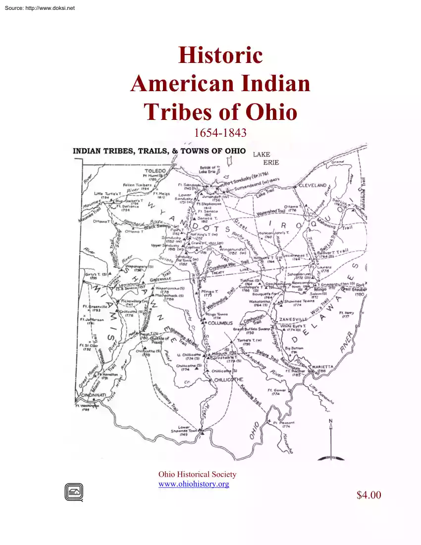
Ottawa, Passamaquoddy, Penobscot, Peoria, Pequot, Piankashaw, Prairie Potawatomi, Sauk-Fox, Seneca, Susquehanna, Swamp-Cree, Tuscarora, Winnebago, and Wyandot. Ohio was occupied by numerous American Indian tribes. In the northwest, the Wyandot were located along the banks of the Maumee and Sandusky rivers; the Shawnee, in the south were located on both sides of the Scioto; the Miami occupied the valleys of the two Miami rivers; the Mingo located in the southeast between the Muskingum and Ohio rivers, and the Delaware, Ottawa, and Chippewa people were scattered throughout. TRAILS AND SETTLEMENTS The original traces or paths through the dense forests of Ohio were created by animals -such as buffalo and deer- in search of food, water, and salt licks. These trails were far enough from streams to avoid swamps and lowlands and sometimes followed the ridges, and became known as “high-ways.” These paths were narrow and well worn in and difficult to travel. Because of this, early people and
explorers traveled single file when they used these traces to pursue game and to get flint. More efficient travel was on streams, rivers, and lakes by canoe, then, when they could go no further, travelers would portage across the land between waters. The most important trails ran north Ohio Historical Society www.ohiohistoryorg Historic American Indian Tribes of Ohio 3 Source: http://www.doksinet and south for they connected Lake Erie with the Ohio River. Settlements grew up along the abundant natural resources near these trails and streams and because of the ease of transportation. Sometime around 1583, the Spaniards introduced the horse as a means of transportation on the North American continent. Within about 100 years, the horse was ridden in the plains states to hunt buffalo. However, horses were grazers and required grasses to eat so they were not practical for the northeast as it was densely forested and lacked enough grazing areas. Grains could have been fed to the horses,
but that would have meant that the American Indians would have to have sacrificed their own food. It wasn’t until more lands were cleared and grasses grew that horses became adaptable to the Ohio country. The trails were used successively by the American Indians, explorers, the military, and settlers. Today the original Lake Trail lies under US Route 20; the Great Trail blazed the way from Pittsburgh to Freemont to Detroit; and the Warrior Trail made its way from Portsmouth through Upper Sandusky, and now is the bed of U.S Route 23 SHELTERS AND DWELLINGS The teepee was generally used as a temporary shelter in a hunting camp. This coneshaped tent had a framework of long poles placed in a circle, set upright they would lean together at the top. This frame was covered with mats or bark Mats were made of cattails, or “flags,” stitched together in sections of about five by fifteen feet. These lightweight mats were easy to transport when rolled up. The wigwam was a circular, or oval,
dome-shaped structure that housed one or two families. The butt-ends of the pole or sapling frame were imbedded in the earth; the tapered ends Ohio Historical Society www.ohiohistoryorg 4 Historic American Indian Tribes of Ohio Source: http://www.doksinet were bent down and tied in place with bark strips. Over this frame was fastened a covering of bark or mats, sometimes a combination of both. Mats were made of cattails, or common marsh “flags,” as they were called. In the center of the domed roof was a smoke hole with a section of bark on a long pole resting against the side of the wigwam that could be adjusted to keep the wind from blowing the campfire smoke back inside. Ohio Historical Society www.ohiohistoryorg Historic American Indian Tribes of Ohio 5 Source: http://www.doksinet The log house, another type of Woodland Indian dwelling, resembled a frontier log cabin. It had a pitched or A-shaped roof The structure was rectangular with side walls of small logs four feet
or more in height and fifteen feet long. Logs were not notched but were laid between pairs of posts driven into the ground at each end. These were tied together at the top with bark strips. End walls about twelve feet long were made of split logs set upright in the ground. Stout forked posts at either end supported the ridgepole From the side walls to the ridge pole, small poles were laid and tied in place to serve as rafters. The roof frame was covered with slabs of lynn bark, overlapped and tied in place. Cracks between the logs were stuffed with moss. Bear skins were hung over the openings at each end to serve as doors Living quarters were on the sides; a series of small fires were laid in the middle down the length of the cabin. An opening in the roof served as a chimney James Smith, a captive among the Ohio Wyandot and Mingo tribes from 1755 to 1759, described such a cabin built for a winter hunting camp to house eight hunters and thirteen women and children. He commented, “And
not withstanding the winters are hard here, our lodging was much better than what I had expected.” The longhouse design was generally associated with the Iroquois and sometimes with the Delaware and Shawnee tribes. The longhouse was a multi-family dwelling, from thirty to more than one-hundred feet in length, and about twenty-five feet wide, and twelve to fifteen feet high. The Iroquois used a rounded or Quonset-type roof, while the Delaware and Shawnee used a pitched or peaked roof. Poles and saplings bound together with tough bark strings formed the framework. This was covered with large sheets of elm or birch bark, overlapping and tied in place to make a weatherproof covering. 6 Ohio Historical Society www.ohiohistoryorg Historic American Indian Tribes of Ohio Source: http://www.doksinet Inside there would be a passageway down the center that contained fireplaces or pits for cooking and heating. There was a smoke hole in the roof over each fire pit The openings at each end of
the longhouse were usually covered with a large animal skin or hide. Inside, each family lived and slept on raised platforms. These platforms extended along the length of the longhouse on both sides. Placed a foot or two above the ground, these platforms were framed with poles and floored with slabs of bark. By the middle 1700s, the Delaware and Shawnee were using smaller dwellings. In 1751, Christopher Gist, an explorer for the Ohio Company, visited the lower Shawnee town at the mouth of the Scioto River. According to his journal, he recounted that there were one hundred forty houses in the town, and the bark-covered council house was ninety feet long. American Indian villages could consist of as many as several hundred dwellings or cabins, or as few as a half a dozen. The villages were generally located near a stream or large spring. Good land for gardens and cornfields and a plentiful supply of firewood were important in determining the location of a village. In prehistoric times,
and even after the Europeans arrived in North America, some American Indian tribes fortified their villages with palisades, or walls, as a protection against enemy attack – but by the mid-1700s, this practice had been discontinued in Ohio. In September 1772, the Reverend David McClure visited New Cornerstown located a few miles east of Coshocton on the Tuscarawas River in Ohio. It was a village of about sixty houses, some made of logs, and some of bark. Reverend McClure saw a number of well constructed hewed log houses with stone chimneys and cellar holes. He was told by the inhabitants that these were built for them during the French and Indian War by their English captives. Some village sites had been in use off and on for many years, perhaps for centuries, by both prehistoric people and the later historic Indians. The valley lands along the Scioto, Mad, Auglaize, Sandusky, and Maumee rivers and their tributaries were among the favorite village locations during the eighteenth
century. CLOTHING AND DRESS Before the encroachment of the Europeans upon the North American continent, the attire of the American Indian was simple and functional. Their clothing was made of animal skins However, the process of turning the hide of a deer or buffalo into garments was a long, hard job. Once the hunt of the animal was successful, using tools made of flint, stone, bone, or shells, the animal was carefully skinned then butchered for food. The women of the tribe took the hide back to camp, stretched it, and staked it on the ground fur side down. Using various handmade tools, the skin was scrapped free of matter. If the skin were to be used for warmth, the fur would have been left intact, if not, the hide would have been flipped over and the hair removed. Once all debris was removed, the skin was rubbed with a mixture of animal fat, brains, and liver then placed aside for several days to allow it to soften. The hide was then washed and worked over to smooth the leather.
Finally, it was tanned by mounting it on a frame over a low fire. This smoking process gave the leather its rich color. Men usually wore a breech cloth made from a rectangular piece of leather. It would be placed between the legs and brought up in front and back then held in place with a leather cord or belt fastened around the waist. A shirt would take two deer skins, each cut into three pieces The body of the animal formed the shirt and the front legs were used to make sleeves. Ohio Historical Society www.ohiohistoryorg Historic American Indian Tribes of Ohio 7 Source: http://www.doksinet Women would wear a large rectangular skin wrapped around their waist and held in place with a leather strap. A dress required two deer skins sewn together with sinew across the top and down the sides. Left over leather could be used to make moccasins. In the winter weather, leggings, capes, or jackets would be layered for warmth. All wearing apparel may have been beaded, painted, or fringed for
decoration. Once trade began with the Europeans, the dress of the American Indian changed to include woven fabrics of bright colors; this added prestige to their wardrobe. Eventually the dress of both the American Indian and the European adapted and borrowed the look of the other in appearance. ART AND CRAFTS The Woodland Indians were craftsmen and artists. Largely self-sufficient, they made whatever they needed from materials available in their environment. This independence began to decline when they became involved in the fur trade. Gradually, they became to depend upon European goods of all sorts and eventually their culture was almost destroyed. Early American Indian artists remain nameless. Much of their work has been lost, but enough has survived to show their creativity. These artists, like artists everywhere, possessed varying degrees of talent and skill. While their art is related to folk art, some American Indian work is exceedingly fine; with a combination of strength and
sensitivity that places it among the fine arts. American Indians were keen observers. They were skilled at reducing whatever they saw to its essence. Often they created beautiful abstract, simplified, stylized shapes and designs from the forms of men, animals, birds, trees, mountains, and all things in nature. However, some of their decorative designs were just that and nothing more, simple, pleasing patterns used to beautify an object. The earlier American Indian artists did not paint in the realistic manner of European artists. They made pictographic drawings and incised carvings on stone, wood, birch bark, buckskin, clay, shell, and similar materials. Certain colors and symbols were sacred or had a specific meaning to the American Indian artists. Undoubtedly, European and American artists who visited the frontier to paint Indians and their life influenced Indian pictorial art to some extent. Indian women did the weaving, tanning, and pottery and basket making. Women also made
footwear and clothing with quill and beadwork decorations. Some women were well known for their skills and the beauty of the designs. Like all craft persons and artists, some had outstanding ability; others were mediocre so they would borrow designs from other persons or other tribes. The creative efforts of the American Indians were part of a cultural pattern, not just an individual expression of art. Everything had a use: bark canoes and log dugouts, burl bowls, war clubs, prayer sticks, bone fetishes, scrimshawed power horns, bark boxes, and shell gorgets. Related to their art and crafts was their belief in spiritual forces that controlled their world. These super-natural beings were protectors who could become enemies if offended. Such spirits might resemble animals or birds, or have grotesque human forms. 8 Ohio Historical Society www.ohiohistoryorg Historic American Indian Tribes of Ohio Source: http://www.doksinet Ritual was important to the Indian artist. The masks of the
False Face Society of the Iroquois were an example. This religious and healing society is still in existence Once, the masks had to be carved from a living basswood tree to retain the mystical life-force of the tree in each mask. Carved masks also had to be stored properly, supplied with offerings of tobacco, and handled respectfully. One of the popular masks of the False Face Society represented Broken Nose, a powerful spirit-being who protected them from evil. RELIGIONS The religious beliefs of the American Indians were a part of their daily lives and actions in a way never entirely understood by the white man. Everything has a soul or spirit, even plants, small creatures, and objects: sometimes they wielded considerable power or influence with the Maneto. Their concept of Life Force or a Great Spirit, Maker of all things, the Manitou, Monedo, or Maneto, was generally translated by the white man to conform with the accepted idea of the Judeo-Christian God. James Smith, during his
captivity among the American Indians in Ohio, found that they differed a great deal in their religious beliefs. Members of the same group or tribe of Wyandot, Ottawa, or Mingo, varied in their religious traditions. By the time of the American Revolution, they had some knowledge of Protestant and Catholic teachings for several years before, the Moravian mission at Schoenbrunn had been established. According to Smith, the Wyandot believed there had been an American Indian female with magical powers who was a prophetess in the far distant past. She was responsible for the creations of the continent. Living on a small island with a few Indians, she prayed to the Great Being, the Life Force, that the island might be enlarged. Her prayers were answered when large numbers of muskrats and tortoises brought mud and other materials to enlarge the island into the continent. Therefore, they considered the land to be theirs; a gift from their great grandmother which the white people had no right to
take. The Shawnee believed that when the world began, one island was created for them and another for the white man. This was the work of the Maker of all things The Delaware believed in the survival of the spirit or soul of man after death. The spirit left the earth to go to another place, where it could be free from the ills and miseries of this world. The Algonquin language group, to which the Shawnee, Delaware, Ottawa, and Miami belonged, believed a supernatural being or guardian accompanied each person. This totem – usually a bird or animal, god or being – was the basis of the fundamental philosophy of the Algonquian people which was never truly understood by the white man. The Miami, originally a prairie people, believed the sun was the Master of life, the Supreme Maker of all things. Smith observed that the Ottawa believed in two great spirits or beings who are at war with each other. The good spirit, Maneto, was kindness and love; while Matchemaneto, was Ohio Historical
Society www.ohiohistoryorg 9 Historic American Indian Tribes of Ohio Source: http://www.doksinet evil. Between them, they governed the universe The Ottawa were divided in their beliefs concerning these two great beings and their powers. Some worshiped the good Maneto, and some served the evil Matchemaneto, perhaps through fear. Others sought to gain favor with both to avoid offending either one. This belief in good and evil god-like beings ruling the universe was held with some variation by other Ohio Indians. Numerous lesser deities or beings, both good and evil, were thought to oppose each other. The good spirits went about repairing the damages done by the evil ones. There was also a belief in witches and witchcraft. Sometimes this belief was the cause of tragedy and misery among the Ohio Indians as people were executed or lived under suspicion because of it. Moravian missionary, David Zeisberger, wrote of the American Indian belief that witches brought misfortune, sickness, or
death to the villages or to individuals. These long-established beliefs persisted well into the nineteenth century. James Smith wrote that during his years of captivity in Ohio, he never actually witnessed anything judged to be supernatural among the Wyandot, Mingo, and Ottawa. Even so, some individuals claimed to be powerful sorcerers and conjurors, and worshiped the Matchemaneto. These were generally the men who caused the missionaries trouble and sought to arouse the suspicions and superstitions of the non-Christian people among them. The American Indians were not alone in their beliefs in witches, superstitions, and strange spirits; throughout the world many people held similar ideas, even in so-called civilized countries with a long-standing Christian tradition. Similar beliefs were held in many areas in rural backwoods American in the eighteenth century. MEDICINE American Indians were afflicted by a number of diseases prevalent among Europeans. David Zeisberger and John
Heckewelder, Moravian missionaries in Ohio in the 1770s and 1780s, recorded some of the physical disorders. “Fairly common were consumption, whopping cough, pneumonia, rheumatism, arthritis, dropsy, asthma, malarial fevers, dysentery, and intestinal worms. They also suffered from tooth decay, sore eyes, blindness, boils, mental disorders, measles, smallpox, and venereal diseases. –Some of these may have been contracted from the Europeans. Additionally, because of the nature of their lives as hunters and warriors, they were exposed to many injuries – broken bones, wounds, and snake bites.” “Their medicines were made from a great variety of roots, bark, leaves, seeds, berries, flowers, and stalks. Some medicinal plants were used when fresh; others were dried and powdered, or prepared as liquids, salves, or poultices.” “The men and women who acted as doctors or healers were divided into two groups. The first were the conjurors or jugglers who sought cures through magic or
superstitious rites and who resorted to all kinds of trickery in their treatments. The second were the “good and honest practitioners,” as John Heckewelder described them, who treated wounds and diseases with reasonable skill and medicines. Heckewelder wrote: 10 Ohio Historical Society www.ohiohistoryorg Historic American Indian Tribes of Ohio Source: http://www.doksinet “I firmly believe that there is no wound, unless it is absolutely mortal, or beyond the skill or our own [white] practitioners which an Indian surgeon (I mean the best of them) will not succeed in healing,” Heckewelder related an instance of a Shawnee who suffered a nearly fatal gunshot wound in his chest, which was completely healed by a Shawnee doctor. AGRICULTURE, HUNTING, AND FISHING The Woodland Indian tribes of the Great Lakes area and throughout the eastern and southern part of the present United States were farmers. Corn, beans, squash, and pumpkin were widely grown in North America. Besides
multi-colored “Indian” corn, the American Indians developed varieties of eight-to-ten row corn. The variety of beans included kidney beans, navy beans, pea beans, pinto beans, great northern marrow beans, and yellow eye beans. The American Indian planted corn and beans in the same hills, and often pumpkins, squash, or melons in the space between. Year after year, the hills were enlarged with the hoe until they became small hillocks. Many other vegetables were grown by the Ohio Indians: turnips, cabbage, parsnips, sweet potatoes, yams, potatoes, onions, and leeks. Watermelon and muskmelon were introduced into North America in the 17th century and were being grown in the interior within a few years. In the spring, the American Indians made maple sugar in large quantities. It was a staple in their diet. They also harvested nuts, berries, wild plums, wild cherries, and paw paws In the great lakes region, wild rice was gathered. The nature and extent of American Indian agriculture is
revealed in the observations of George Will, a soldier in General Wayne’s campaign against them along the Auglaize and Maumee rivers in the summer of 1794: “Here are vegetables of every kind in abundance, and, we have marched four or five miles of cornfields down the Oglaize, and there is not less than one thousand acres of corn around the town.” Protein was supplemented in the diet by fishing with common tools like the bow and arrow, gigs, hooks, nets, traps, and weirs. In the fall and winter, the American Indian hunted and trapped beaver, muskrat, raccoon, deer, buffalo, and black bear. Game was hunted for its meat and hides. The most common hunting devices were the spear and the harpoon. The spear was hurled by hand and the arrow was shot with a bow. Knives, axes, clubs, and traps were also used During this time, the hunters and their families moved about, living in winter hunting camps. Ohio Historical Society www.ohiohistoryorg Historic American Indian Tribes of Ohio 11
Source: http://www.doksinet THE FUR TRADE The fur trade in North America began with the early contact between the American Indians and the Europeans. Within a few years, French, English, and Dutch fur traders were bartering with the American Indians over a large part of what in now the northeastern and central United Stated and Great Lakes areas. In Europe, there was a good market for furs, while in America there were seemingly limitless numbers of fur-bearing animals, especially beavers. Europeans offered the American Indians a line of goods which included iron axes, tomahawks, knives, eye-hoes, awls, fish hooks, trade cloth of various colors, woolen blankets, linen shirts, brass kettles, trade silver jewelry, assorted glass beads, and guns and powder. The American Indians were eager to have these things and they paid for them with furs. While the beaver pelt was always the foundation of the trade, otter, mink, fox, bear, and deer were also harvested. In time, the American Indians
became so dependent on trading, their own culture deteriorated. The imported goods of Europe replaced the things they had formerly made for themselves using the resources available in their environment. There were other evils in the trade. Competition led to conflicts between the English and the French. Although their chiefs often saw that each side was using them, they argued that they should let the white men fight their own wars, they became involved. While there were honest traders who dealt fairly with the American Indians, too many greedy, unscrupulous men in the trade cheated and exploited them. These men corrupted the Indians with alcohol and robbed them of their furs. Despite the opposition of conscientious traders on both sides, alcohol was an important and permanent part of the trade. It had a devastating effect on many tribes Numerous witnesses have been written of the violence and tragedy that the liquor trade brought to the American Indian villages. 12 Ohio Historical
Society www.ohiohistoryorg Historic American Indian Tribes of Ohio Source: http://www.doksinet On February 8, 1806, the average prices for furs and peltries by the trader at Fort Wayne, Indiana were: Raccoons Foxes, Cats, and Fishers Minks Musk Rats (grown ones) Otters Bears (grown ones) Beavers Buck Skins (always) Doe Skins 77 Drefsd, Does Skins, Bucks & Does 5 Indian Mats 112 Com. Moccasins 13 Fine Ditto = = = = = = = = = = = = = 37½ to 40 cents each 50 to 67 cents each 50 cents each 25 cents each 4 to 5 dills each 4 to 5 dills each 125 cents each 100 cents each 67 to 75 cents each 75 cents each 25 cents each 50 cents each Inventory of Merchandise [sic] peltry and other property on hand at the United States Trading House, Fort Wayne, 1810: 3 38 2 85 780 16 31 29 1 300 6 1 1 2 18 20 3 330 5 9 7½ 14 14¾ 6” 400 200 47 23 5¼ 1 116 7 2 25½ 27 15 3 2¾ 11 25 6 5 1 14 58 196 10 35 119 2 nests Copper kettles without Covers (7 in a nest) 100 ½ lb. Rifles casks Powder lb. BB
Patent Shot pair Ear Bobs Ca. pair Fluted Wrist Bands wt. 14 oz 2 Dwts Ca Head Bands with Eagles wt. 23 oz 8 Dwts Ditto Ditto 29 oz. 18 Swts doz. Broaches [sic] wt 3 oz 5 Dwts small Ditto 1” 12 Gorgets # doz. Larger Round Broaches Wt 5 oz 12 Dwt doz. Ear Wheels Wt 3 oz boxes Bar Lead Beaver Traps Ditto Traps Traps lbs. Pig Tail Tobacco Shot Bags yds. Yellow Flannel Red Ditto White Ditto Blue Cloth Stroud Cloth Small Crosses Crosses Nose Wheels Fish Lines with Hooks dz. Ivory Combs gross Straight Awls Bullet Moulds Power Horns Large Ditto lb. Powder lb. Vermilion com. Gun Locks Double Roller Ditto Bridled Ditto Best Ditto pair Two Point Blankets pair 3 Point Ditto pair 3½ Point Ditto pair American 3 Point Ditto Calico Shirts Pipe Tomahawks lb. Buck Shot Fowling Pieces Plain Tomahawks Axes Brood Axes = = = = = = = = = = = = = = = = = = = = = = = = = = = = = = = = = = = = = = = = = = = = = = = = = = 90 cents per Lb. $12.50 $14.50 cwt $12.59 P 100 pair $1.60 per ounce $18.36 Per Doz
$ 2.25 $ 3.00 $ 1.67 .15 $ 1.25 .40 .41 .41 .12/6 .96½ 6½ .20½ 3.00 .37½ .40 1.40 1.20 3.13 2.87 2.80 2.27 3.68 3.75 1.20 1.50 11.33 Ohio Historical Society www.ohiohistoryorg Historic American Indian Tribes of Ohio 13 Source: http://www.doksinet THE FIVE MAJOR TRIBES OF OHIO The Shawnee, 1600–1833, migrated from their homelands of South Carolina and Tennessee into eastern Pennsylvania by 1690. Then in 1720, forced further west by hostile tribes and encroaching Europeans, they began to move into the upper Ohio valley. By 1750, they were established in the Scioto valley in southern and central Ohio. It was they who offered the stiffest resistance to the advance of the Americans. Three Shawnee chiefs have left their names upon the records – Cornstock, Blue Jacket, and Tecumseh. Other well known Shawnee were Black Hoof, Black Fish, and Wolf. Black Hoof, 1731-1831, the Shawnee chief called Ca-tahe-cassa, fought for 40 years to hold lands north of the Ohio River. But he
reconciled to peaceful association with the EuroAmericans after he signed the Treaty of Greene Ville Black Hoof visited President Jefferson early in 1802 and made the following requests and complaints: “We live in a bad place for farming, the water is very bad in the summers; if you turn your head back you will hear the lamentations of our women and children, distressed for want of clothing and by hunger, we hope you will pity them and relieve them. It is our desire to live like good neighbors, as long as the grass grows and the water runs in the rivers.” “The second request we make is that you will stop your people from killing our game, at present they kill more than we do; they would be very angry if we were to kill a cow or a hog of theirs, the little game that remains is very dear to us.” “We hope every request will be granted and we beg your assistance in getting all necessary farming tools, and those for building houses, that we may go to work as quickly as possible,
and likewise to furnish us with some domestic animals.” Black Hoof, who at the time of his death was rumored to be 100 years old, died near Wapakoneta, Ohio. Tecumseh, 1768-1813, the Shawnee leader has been ranked with the greatest chiefs and hero-figures of American Indian history. He was a warrior famous for his courage, intelligence, and character. But with his skills as an orator and leader, he labored to unite American Indian tribes into a strong confederation to prevent further division of tribal lands and to resist the advance of white settlements. In 1811, Tecumseh warned of the fate the American Indians would suffer unless they united to resist the white man: “.but what need is there to speak of the past? It speaks for itself and asks, ‘Where is the Pequod? Where the Narragansetts, the Mohawks, Pacanokets, and many other once powerful tribes of our race?’” “They have vanished before the avarice and oppression of the white men, as snow before a summer sun. In the
vain hope of alone defending their ancient possessions they have fallen in the wars with the white men.” “Look abroad over their once beautiful country, and what see you now? Naught but the ravages of the pale face destroyers meet our eyes. So it will be with you Choctaws and Chickasaws!” “Soon your mighty forest trees under the shade of whose wide spreading branches you have played in infancy, sported in boyhood, and now rest your wearied limbs after the fatigue of Ohio Historical Society www.ohiohistoryorg 14 Historic American Indian Tribes of Ohio Source: http://www.doksinet the chase, will be cut down to fence in the land which the white intruders dare to call their own.” “Soon their broad roads will pass over the graves of your fathers, and the place of their rest will be blotted out forever. The annihilation of our race is at hand unless we unite in one common cause against the common danger, and thus escape the common fate.” “Your people, too, will soon be as
falling leaves and scattering clouds before their blighting breath. You, too, will be driven away from your native land and ancient domains as leaves are driven before the wintry storms.” The Miami, 1700–1818, migrated from Wisconsin and penetrated into western Ohio in the early 1700s, having already established villages in Illinois, Michigan, and Indiana. In 1730, the first English traders are known to have been trading gunpowder, hatchets, rum, blankets, and beads with the Miami for their valuable furs. Their principal village in Ohio was Pickawillany – near present Piqua – but their strongholds were dotted throughout the Maumee and Miami river valleys. Villages there were destroyed in the 1790–1794 campaigns of generals Josiah Harmar and Anthony Wayne. Although the Miami were notable warriors under the firm leadership of Little Turtle, they won some important victories of the invaders from the east. Another notable Miami was La Damoiselle. The Delaware, 1700–1829. The
Delaware, or Lenilenape, were refugees from the east coast in New Jersey and Delaware. They were defeated by the Iroquois and crowded out by English settlers. They occupied large areas of eastern Ohio, including the Muskingum and Tuscarawas river valleys. In alliance with the Shawnee, they stubbornly opposed the frontiersmen. Some famous Delaware are White Eyes, Shingas, Beaver, Newcomer, Killbuck, Buchongehelas, and Tishcohan. The Ottawa, 1740–1833, migrated from Ontario and the upper Great Lakes, mainly Michigan and Wisconsin, and settled in northwestern Ohio. Their best-known chief was Pontiac. Famous for the “Pontiac Rebellion,” in 1763, which was a carefully planned uprising of many tribes by which all English garrisons and settlements in the Northwest were to be surprised and destroyed on the same day. The English fort on Sandusky Bay fell, but Detroit and Fort Pitt did not. The campaign failed The Wyandot, 1740–1843, were a segment of the Huron, and were pushed out of
Ontario, Canada by the Iroquois. They first settled in northern Michigan, then migrated south into the Maumee and Sandusky valleys. One of their chiefs, Tarhe (The Crane), signed the Treaty of Greene Ville. Half King, Orontony (Nicholas), and Pomoacan were also noted Wyandot chiefs. Red Jacket, 1752-1830, the famous Seneca leader and orator called Sa-Go-Ye, or Wat-Ha, or Hee Keeps-Them-Awake, was for the most of his life a champion of Native American rights and their traditional culture and religion. Ohio Historical Society www.ohiohistoryorg Historic American Indian Tribes of Ohio 15 Source: http://www.doksinet The following quotes are from a speech Red Jacket made in reply to an offer by some white men to establish their religion on the reservation: “Brother! The Great Spirit has made us all. But he has made a great difference between his white and red children. He has given us a different complexion and different customs To you he has given the arts; to these he has not
opened our lives. We know these things to be true Since he has made so great a difference between us in other things, why may not we conclude that he has given us a different religion, according to our understanding? The Great Spirit does right. He knows what is best for his children We are satisfied” “Brother! We do not wish to destroy your religion, or take it from you. We only want you to enjoy our own.” “Brother! You say you have not come to get our land or our money, but to enlighten our minds. I will now tell you that I have been at your meetings and saw you collecting money from the meeting. I cannot tell what this money was intended for, but suppose it was for your minister; and if we should conform to your way of thinking, perhaps you may want some from us.” “Brother! We are told that you have been preaching to the white people in this place. These people are our neighbors. We are acquainted with them We will wait a little while, and see what effect your preaching
has upon them. If we find it does them good and makes them honest and less disposed to cheat Indians, we will then consider again what you have said.” The name Mingo was also applied to a group of Mohawks, Cayugas, and Caughnawagas who were Iroquois. For various reasons these people left the Iroquois Confederacy in New York and moved into Ohio. They intermarried with the Wyandot and other Ohio tribes Mingo Chief Logan, after his family was massacred, delivered a speech. It was recorded by Thomas Jefferson in his “Notes on Virginia.” It was later published in the Virginia Gazette With tears, Logan related his story: “I appeal to any white man to say, if ever he entered Logan’s cabin hungry and I gave him not meat; if ever he came cold or naked and I gave him not clothing. During the course of the last long and bloody war, Logan remained in his cabin an advocate for peace. Nay, such was my love for the whites, and those of my own country pointed at me as they passed by and
said, ‘Logan is the friend of white men.’ I had even thought to live with you but for the injuries of one man. Colonel Cresay, the last spring, in cold blood, and unprovoked, murdered all the relatives of Logan, not even sparing my women and children. There runs not even a drop of my blood in the veins of any human creature. This called on me for revenge. I fully glutted my revenge For my country I rejoice at the beams of peace. Yet, do not harbor the thought that mine is the joy of fear, Logan never felt fear. He will not turn on his heel to save his life. Who is there to mourn for Logan? Not one.” ADAPTING TO EACH OTHER’S WAYS James Smith, 1737–1812, for nearly five years, was a captive of the Caughnewaga in Ohio. Adopted as an American Indian, he lived their way of live from 1755 to 1759 Smith came to understand them and kept a journal of his experiences. In 1799, he published a narrative of his life, his adventures on the frontier, in Pontiac’s War, and was an officer
in the Revolution. Ohio Historical Society www.ohiohistoryorg 16 Historic American Indian Tribes of Ohio Source: http://www.doksinet James Smith died in 1812 near Paris, Kentucky. His book is one of the best accounts of an American Indian captivity. During his initiation into the tribe, he was told: “My son, you are now flesh of our flesh, and bone of our bone. By the ceremony which was performed on this day, every drop of white blood was washed out of your veins; you are taken into the Caughnewaga nation, and initiated into a warlike tribe; you are adopted into a great family, and now received with great seriousness and solemnity in the room and place of a great man. After what has passed this day, you are now one of us by an old strong law and custom – My son, you have now nothing to fear – we are now under the same obligations to love and to defend one another; therefore, you are to consider yourself as one of our people.” Mary Jemison, 1740-1833. Mary Jemison was
captured by the American Indians in Pennsylvania in 1757 or 1758. Her parents and their three younger children were killed at this time. Mary spent most of her life among the American Indians, who named her Dichewamis, “The Pretty One.” The early years of her captivity were spent in Ohio and she married there Mary, a tiny blonde about four and a half feet tall, was a pleasant woman and was respected by both the American Indians and the white people. In New York State in 1833, she died at the age of ninety leaving many descendants. The narrative of her life, which was reprinted many times, contains the following account of her marriage: “Not long after the Delaware came to live with us at Wishto, my sisters told me that I must go and live with one of them, whose name was She-nin-jee. Not daring to cross them, or disobey their command, with a great degree of reluctance, I went; and Sheninjee and I were married according to Indian custom.” “Sheninjee was a noble man; large in
stature, elegant in his appearance; generous in his conduct; courageous in war; a friend in peace, and a great lover of justice. He supported a degree of dignity far above his rank, and merited and received the confidence and friendship of all the tribes with whom he was acquainted. Yet Sheninjee was an Indian The idea of spending my days with him as first seemed perfectly irreconcilable to my feelings; but his good nature, generosity, tenderness, and friendship towards me, soon gained my affection; and strange as it may seem, I loved Him! -- To me, he was ever kind in sickness and always treated me with gentleness; in fact, he was an agreeable husband, and a comfortable companion. We lived happily together till the time of our final separation, which happened in two or three years after our marriage, as I shall presently relate” Sheninjee became ill and died after sending Mary and her small son to his American Indian sisters in the Genesee county of New York where he was to have
joined them. John Brickell, 1781–1844, was captured by the American Indians near Pittsburgh in 1791 when he was ten years old. He was adopted into the Delaware family of Whingy Pooshies, “The Big Cat,” and lived with the Indians in their Maumee River villages until his release in 1795. Brickell settled on the east bank of the Scioto in 1797 on the site of the future city of Columbus, Ohio. He was probably the first settler on that site “The Delaware are the best people to train up children I ever was with. They never whip, and scarce ever scold them. I was once struck one stroke, and but once while a member of the family, and then but just touched. They are remarkably quiet in the domestic circle A dozen may be in one cabin, of all age, and often scarcely noise enough to prevent the hearing of a pin fall on a hard place. Their leisure hours are, in a great measure, spent in training up their children to observe what they believe to be right. They often point out bad examples to
them and say, ‘See that bad man: he is older than you: if you do as he does, everybody will despise you by the time you are as old as he is.’ They often point to good examples as worthy of imitation, such as braves and honest men. I know I am influenced to good, even at this day, more from what I Ohio Historical Society www.ohiohistoryorg Historic American Indian Tribes of Ohio 17 Source: http://www.doksinet learned among them, than what I learned among people of my own color. Well might Jefferson say, ‘The principles of their society forbid all compulsion.’” REMOVAL OF THE AMERICAN INDIANS As early as 1779, four or five hundred Shawnee had moved to Missouri. Other independent groups of American Indians had also emigrated without waiting for an organized removal. Among them were some Kickapoo, Shawnee, and Delaware, whom the Spanish had permitted to settle in Missouri in the 1790s. General Anthony Wayne’s campaign of 1792 through 1794 against the American Indians ended
forty years of war and border raids in the Ohio valley. In August of 1795, General Wayne and the American Indians signed the Greene Ville Treaty thereby the American Indians gave up about two-thirds of the present area of Ohio. They continued to occupy the northwestern part of the state above the Greene Ville Treaty line. Surveyors, land speculators, settlers, and developers began moving into the newly-opened Ohio country. An increasing number of people sought their share of Ohio lands. Squatters began trespassing onto the Indian reservation. As early as July 1803, President Thomas Jefferson made the first direct and official proposal for the removal of the American Indians to the West. The argument in support of the removal proposal was that they would be free from white interferences in the West and would never have to face loss of their homes again. In January 1825, President James Monroe presented a definite removal policy in a message to Congress. In 1829, President Andrew Jackson
and many American political leaders were working hard for the removal of the eastern American Indians to the west of the Mississippi River. The Indian Removal Bill was passed May 28, 1830 It provided the authority President Andrew Jackson needed to force the American Indians to move west of the Mississippi River. Speckled Snake, an aged Creek, more than 100 years, old, could have been speaking for all of the American Indians about to be displaced from their home land. With resignation and bitterness, the old man said: “Brothers! I have listened to many talks from our great father. When he first came over the wide waters, he was but a little man – very little. His legs were cramped by sitting long in his big boat, and he begged for a little land to light his fire on. But, when the white man had warmed himself before the Indians’ fire and filled himself with their hominy, he became very large. With a step he bestrode the mountains, and his feet covered the plains and the valleys.
His hand grasped the eastern and the western sea, and his head rested on the moon. Then he became our Great Father. He loved his red children, and he said, ‘Get a little further, lest I tread on thee.’” 18 Ohio Historical Society www.ohiohistoryorg Historic American Indian Tribes of Ohio Source: http://www.doksinet “Brothers! I have listened to a great many talks from our great father. But they always began and ended with this –‘Get a little further, you are too near.’” Between 1818 and 1838, the American Indians of Ohio, Indiana, and Illinois gave up most of their land except for small reserves. The Wyandot alone relinquished title to four and a half million acres. The Miami ceded 6,700,000 acres in Indiana, and 297,000 acres in Ohio By this time, the American Indians generally were reduced in numbers, and were corrupted morally and physically by whiskey. They were impoverished and badly in debt to the traders. Agent Samuel Milroy reported that among the Miamis,
450 men and 36 women had died in drunken knife brawls from 1821 to 1839. The Ohio Delaware and some Seneca were anxious to go West to escape from conflicts with the white population. Those who left in 1820 traveled overland and lost many of their horses to horse thieves. Bad weather, hunger, sickness, and a lack of supplies caused much suffering during the journey. The last Delaware – about 100 in number – and the Seneca left Ohio in 1831. The remnant of the Delaware lands was sold to the War Department for $3,000 and later resold for $10,000. The last of the Shawnee and Ottawa left Ohio for Kansas in 1832 In 1843, the Wyandot were the last American Indians to be removed from Ohio. They numbered 674 persons. When they left, they ceded over 163,000 acres of land in two reserves. The American Indians were transported westward by canal, steamboat, or other river boats, generally from Cincinnati. The steamboats were often overcrowded. After reaching Missouri, these displaced people had
to continue overland to their destination. Others made their entire journey west by wagon, on horseback, or afoot. The removals were too often poorly planned and badly executed by contractors with no previous experience. Many of the American Indians were bitterly opposed to moving west. Some of the Miami had to be tied up for transportation by canal boat to Cincinnati. Several hundred of them managed to evade capture and roamed about Indiana for years, living as best they could off the land. Too often the American Indian departures were delayed until late in the year. The cold, wet weather and inadequate clothing, shelter, and food supplies resulted in hardship and misery for the unfortunate emigrants. They suffered from measles, cholera, fevers, and hunger Many old people, young children, and the sick or infirmed died on the way. Whiskey peddlers and horse thieves followed almost all the removal groups like birds of prey. Dishonest, greedy traders presented exorbitant and fraudulent
claims to the government for goods supposedly supplied to the American Indians. Many said claims were eventually paid by the federal government from tribal annuity monies intended for the American Indians. This was a tragic last chapter to the history of the American Indians in Ohio. Ohio Historical Society www.ohiohistoryorg Historic American Indian Tribes of Ohio 19 Source: http://www.doksinet OHIO HISTORICAL SOCIETY INDIAN SITES Big Bottom. Southeast of Stockport, Ohio Fallen Timbers. Near Maumee, Ohio Flint Ridge. County Route 668, 3 miles north of Brownsville, Ohio Fort Ancient. State Route 350, 7 miles southeast of Lebanon, Ohio Fort Hill. Township Route 256, 3 miles south of Cythiana, Ohio Fort Jefferson. Fort Jefferson, Ohio Fort Meigs. State Route 65, Perrysburg, Ohio Fort Recovery. State Routes 119 and 49, Mercer County, Ohio Leo Petroglyph. Near Jackson, Ohio Logan Elm. State Route 361 south of Circleville, Ohio Miamisburg Mound. Miamisburg, Ohio Newark Earthworks.
State Route 79, Newark, Ohio Piqua Historical Area. N Hardin Road, off State Route 66 north of Piqua, Ohio Seip Mound. Near Bainbridge, Ohio Serpent Mound. State Route 73, 4 miles NW of Locust Grove, Ohio Shrum Mound. Columbus, Ohio Story Mound. Chillicothe, Ohio OHIO HISTORICAL SITE MARKERS Some Snapshots of American Indian Events in Ohio Ashland County: Greentown Delaware Village. A migration of Indians throughout Ohio began due to unstable conditions created by the American Revolution. The massacre of Christian Indians at the Moravian mission of Gnadenhutten in 1782 and Colonel Crawford’s expedition against Wyandot and Delaware towns along the Sandusky fueled insecurities. Delaware, including a small group of Mingo Indians, abandoned the village of Helltown, five miles southwest of this site, and settled Greentown as early as 1783. Greentown, situated on an elevation on the Black Fork beyond the clearing behind this site, was presumably named for British loyalist, Thomas Green.
John Chapman (Johnny Appleseed) had an amicable relationship with the Delaware, owned land throughout the Black Fork Valley, and was known to visit Greentown on his travels throughout Ohio. Other visitors to the village included the Shawnee Prophet; Munsee Delaware leader, Captain Pipe; and local preacher, James Copus. Observers noted that there were more than one hundred and fifty dwellings at Greentown by 1812. Although considered peaceful, the intentions of the Greentown Indians were questioned during the War of 1812. Following General William Hull’s surrender to the British at Detroit on August 16, 1812, residents were removed from Greentown for fear that they would aid “unfriendly” Indians. The removal is dated sometime between August 27 and September 3, 1812. Greentown residents were uncertain about what would occur after removal and were hesitant to obey the orders. Chief Armstrong was assured, through the urging of James Copus, the Greentown’s property would be
inventoried and protected until peace ensued. However, a faction of militiamen who “assisted” in the removal stayed behind and set fire to the village. Consequently, the village remained essentially abandoned after the War of 1812. Frontier Violence during the War of 1812. Tensions between Native Americans and EuroAmerican settlers remained high on the Ohio frontier during the War of 1812 Grievances mounted rapidly following the forced removal of the Greentown Delawares to Piqua in the late Ohio Historical Society www.ohiohistoryorg 20 Historic American Indian Tribes of Ohio Source: http://www.doksinet summer of 1812. On September 10, British-allied Indians attacked and killed the Frederick Zimmer family and neighbor Martin Ruffner one mile north of here. Five days later, on September 15, Reverend James Copus and three militiamen – George Shipley, John Tedrick, and Robert Warnock – were killed while defending Copus’ family from a raiding party one mile south of this site.
Although several Indians were reported killed and wounded during the Zimmer and Copus incidents, no accurate count of Native American casualties survives. In 1882, a reported 6,000 spectators converged in this area to participate in dedicating two monuments over the graves of the fallen settlers and soldiers. Tradition holds that Johnny Appleseed raced throughout the region warning others of impending attack following these incidents. His name was included on the 1882 Copus memorial, the earliest known monument erected to his memory and legend. Carroll County: The Ohio Country in the Revolution. The ancient trail that passed near this spot was the major overland route entering the Ohio Country from the east through the 1700s. Also known as the Tuscarawas Path, the Great Trail was used by Native Americans, European explorers, fur traders, missionaries, military expeditions, land agents-and–settlers after Ohio became a state. In January 1761, during the French and Indian War, Major
Robert Rogers and thirty-eight rangers passed en route to Fort Pitt after taking Fort Detroit from the French. In 1764, during “Pontiac’s Conspiracy,” Colonel Henry Bouquet crossed here with an army of 1,500 men on his way to Goshachgunk (Coshocton), where he treated the Delaware and freed captives. During the American Revolution, the Continental Army under General Lachlan McIntosh camped here for two days in November 1778. The Ohio Country in the Revolution. The western wilderness that later became the state of Ohio played a major role in American, British, and Native American strategy during the American Revolution. In 1778, General George Washington ordered General Lachlan McIntosh to establish a new fort in Ohio to provide a base for a spring campaign on Fort Detroit, held by the British and allied tribes. That fall McIntosh set out from Fort Pitt with over 1,200 troops On the nights of November 13 and 14, 1778, McIntosh’s expedition camped at this site. They subsequently
joined forces with friendly Delawares and proceeded west to the Tuscarawas River, where they fulfilled their mission by establishing Fort Laurens. Located at present-day Bolivar, it was the only Continental Army fort built in Ohio during the Revolution. Champaign County: In Memory of Simon Kenton. Simon Kenton who is buried here During the Revolutionary War he frequently served as scout under George Rogers Clark and later praised Clark for his role in saving the Kentucky settlements. Kenton’s Indian captivity of 1778-9 acquainted him with the Mad River country where he subsequently provided leadership in its development. Though a legendary frontier scout and rifleman, Kenton was never biased against the Indians. Clinton County: Deserted Camp. Near this site in October 1786, General Benjamin Logan with an army of 700 Kentucky volunteers camped on their way to destroy seven Indian towns in the Mad River Valley. During the night a renegade deserted the camp to warn the Indians The army
burned 200 cabins and 15,000 bushels of corn before returning. Later this site became an important survey point. Ohio Historical Society www.ohiohistoryorg Historic American Indian Tribes of Ohio 21 Source: http://www.doksinet Coshocton County: Bouquet’s Expedition. Lt Col Bouquet with 1500 British regulars and American militia penetrated the Ohio wilderness to crush Chief Pontiac’s Indian conspiracy. Here at the forks of the Muskingum River during October and November, Bouquet subdued the Delawares, Senecas, and Shawnee without firing a shot, secured the freedom of every colonial captive, and obtained promises of peacea feat unequaled in colonial American history. Koquechagachton – Chief White Eyes. In the early 1770s, Chief White Eyes (Koquechagachton) of the Delaware tribe founded White Eyes Town approximately two miles southeast of this marker on a plain near present day West Lafayette. A friend of the Moravian leader David Zeisberger, White Eyes was an ardent supporter
of Moravian missionary efforts and kept the Delawares neutral during the American Revolutionary War. White Eyes’ dream was to bring his people under the influence of Christianity. He also hoped to establish a fourteenth state for the Indian nations, which would join the other thirteen. White Eyes died at the height of his career in November 1778 near Pittsburgh. The cause of his death remains open to question Crawford County: Village of Chatfield. For centuries this area was used by Indian tribes as a hunting ground Vast swamp forests of elm, ash, beech, pin oak, and maples lay on all sides. To the east, a large cranberry bog was covered by water most of the year. Indian hunting camps on the headwaters of Sycamore Creek were the scene of plentiful harvests both of game and cranberries. These wetlands produced abundant game after most sections of country were settled and farmed. Today, extensive drainage has changed the area into productive farmland. Seccaium. On the banks of the
Olentangy River, at the bend where the stream turns southwest is the legendary site of Seccaium. This 17th century village was located on the portage to the Sandusky River, and was recognized by the Indians as a neutral ground for tribal councils where claims to hunting territories could be peacefully settled and goods could be traded. In the early 20th century, this site was an amusement part on the interurban electric railway. Crawford’s Expedition, 1782. Col William Crawford and Dr John Knight, separated from the American troops following the Battle of Upper Sandusky, June 4-5, were captured by Indians on June 7 at a site about five miles southeast of this marker. Taken first to Chief Wingenund’s camp north of Crestline, they were then taken, on a trail passing near this marker, to a bluff near Tymochtee Creek northwest of Upper Sandusky. Crawford was tortured and burned at the stake on June 11. Knight later escaped For years afterward, Crawford’s fate inflamed the frontier
sentiment against the Indians. Crawford’s Expedition. Col William Crawford’s army of 480 Pennsylvania volunteers passed near this site on June 3 to attack the Indians near Upper Sandusky. On June 4-5 they encountered a combined force of Shawnees, Delawares, Wyandots, and, unexpectedly, Butler’s Rangers, a British unit from Detroit. The expedition was a disaster; about 300 American escaped. On June 6, about six miles west of this marker, the opposing forces met again at the “Battle of Olentangy.” With minor losses, the Americans continued their retreat, reaching the Ohio River on June 13. Crawford was captured, and burned at the stake on June 11 Cuyahoga County: Pilgrim’s Rest. Returning to Ohio from Detroit following the massacre of Christian Indians at Gnadenhutten in 1782, Moravian missionaries David Zeisberger and John Hackewelder settled Ohio Historical Society www.ohiohistoryorg 22 Historic American Indian Tribes of Ohio Source: http://www.doksinet their Indian
congregation at this site because it was still too dangerous to return to the Tuscarawas valley. The village was named Pilgerruh, or “Pilgrim’s Rest” Hostile Indians forced this mission to move to present Erie County. Darke County: Tecumseh. One of the most influential Native Americans of the 19th century, Tecumseh was born in 1768 in the Pickaway settlements on the Mad River and raids by older siblings at Old Town. A prominent Shawnee war leader who vigorously opposed American expansion, he fought at the Battle of Fallen Timbers but refused to attend the subsequent signing of the Treaty of Greene Ville in 1795. Angered by purchases of Native American land in Indiana by the United States, Tecumseh promoted a pan-Indian confederacy to resist the encroachment of white settlers, traveling thousands of miles throughout the western and southern frontiers in an effort to gain supporters for the alliance. Tecumseh sided with the British during the War of 1812 and was killed at the
Battle of the Thames on October 5, 1813. His death ended hope for a united Indian coalition. Shawnee Prophet’s Town. Tecumseh and his younger brother Tenskwatawa (open Door or the Shawnee Prophet) established a village here in 1805 as a mission for Native American unity. Upon receiving a vision from the Great Spirit or Master of Life, Tenskwatawa vowed to renounce alcohol and preached to return to traditional Indian practices, native foods, implements, dress, and ceremonies of their ancestors. Tensions grew as settlers feared the growing contingent living south of the Greene Ville Treaty line. Pressured by William Henry Harrison, the Prophet moved his followers to the Indiana Prophetstown in 1808, which was destroyed in the ill-fated Battle of Tippecanoe in 1811. During the Shawnee removal west in 1826, the Prophet asked the U.S Army for permission to spend a few days here to honor their ancestors The Prophet died in November 1836 and is buried somewhere under modern Kansas City.
Fort Jefferson. During the Indian Wars of 1790-1795, the United States built a chain of forts in the contested area of what is today western Ohio. These forts were built as a result of various tribes of the region attacking the encroaching American population as they moved north of the Ohio River. In October 1791, General Arthur St Clair, governor of the Northwest Territory, set out on a mission to punish the tribes and on October 12, ordered his forces to build Fort Jefferson, the fourth link in that chain of forts stretching north from Fort Washington (Cincinnati) to Fort Deposit (Waterville). Each fort was generally a hard day’s march of each other, and the site was chosen because of nearness to a supply of fresh water. The fort was named in honor of Secretary of State Thomas Jefferson. St. Clair’s Defeat General Arthur St Clair, governor of the Northwest Territory, left Fort Jefferson on October 24, 1791, on a mission to subdue Indian tribes that had attacked white settlers
coming north of the Ohio River. St Clair and his forces progressed only about 28 miles before halting at the east branch of the Wabash River. On November 4, forces under Chief Little Turtle inflicted the worst defeat every by the Indians upon the United States army. Over 600 soldiers were killed and 300 wounded. During the next 24 hours, survivors made their way back to Fort Jefferson. Within two years, General “Mad” Anthony Wayne assembled the Legion of the United States for another campaign against the Indians. In October 1793, Wayne used Fort Jefferson as a supply base during the campaign that resulted in the American victory of Fallen Timers in August 1794. The subsequent August 1795 Treaty of Greene Ville assured peace in Ohio for the next decade. Ohio Historical Society www.ohiohistoryorg Historic American Indian Tribes of Ohio 23 Source: http://www.doksinet Treaty of Greene Ville, 1795. Following General Anthony Wayne’s victory at Fallen Timbers, members of the western
tribes assembled at Fort Greene Ville to settle on terms of peace. Representatives of the Wyandot, Delaware, Shawnee, Ottawa, Chippewa, Ottawa Pattawatimi, Miami, Eel River, Wea, Plankeshaw, Kickapoo, and Kaskaskia sighed the treaty on August 3, and agreed to cede claims to lands east of the Cuyahoga River to Fort Laurens in Tuscarawas County and south of a line running west to Fort Recovery. In return, the United States offered payment and annuities in the form of goods and ceded claim to most land north and west of the treaty line. This treaty marked the end of the Indian Wars in the Ohio Country, forsaking boundary violations by both parties, and established the official western border of the United States, opening much of Ohio for settlement. Erie County: Huron’s First Inhabitants. Huron and Erie Counties are rich in Native American history During the construction of the nearby Ohio Route 2 bypass, archaeologists in 1976-77 uncovered three Native villages and burial sites. The
Anderson site, overlooking the Old Woman Creek estuary, contains artifacts dating to the fifteenth century A.D The site was once a permanent village, with remains of bowls, fire pits, and even traces of food found among its artifacts. The Jenkins site, also near the estuary, was a winter camp for Indians. Excavators there found several pieces of pottery carbon-dated to 1470 A.D The final dig, the Enderle sitelocated west of the Huron Riverwas strictly a burial site. The discovery of European objects in its graves suggests its creation by a more recent people, such as the Delaware of Wyandot Indians. In 1805, Native Americans in the Firelands signed a land cession treaty at Fort Industry (modern Toledo), and in succeeding years were compelled to leave the region. Fort Sandusky. Erected by the British near this junction in 1761; destroyed by the British during Pontiac’s Conspiracy in 1763. The fort was strategically located near Indian towns and trading posts on the Great Indian Trail
between Detroit and Pittsburgh. Gallia County: The Dunmore War 1774. The Shawnee and Delaware Indians grew restless as numbers of Virginians encroached on their lands by settling along the Ohio River. On October 10, 1774, Lord Dunmore, of the Virginia Colony, ordered Colonel Andrew Lewis and his 1100 Virginia militiamen to attack the Shawnee Indians near Chillicothe, Ohio. While Lewis’ army camped across the Ohio River at Point Pleasant, [West] Virginia, Shawnee Chief Cornstalk, with 1000 warriors, crossed the river upstream for a surprise attack on the Virginia militia. After a five hour battle, the Shawnee retreated west across the Ohio. Some refer to this as the last battle fought by the Colonists while subject to British rule, and really, the first battle of the American Revolution. On November 5, 1774, Lord Dunmore at Camp Charlotte on the Pickaway Plains, Dunmore’s officers met at Fort Gower, Hockingport, Ohio (48 miles upstream) and passed this resolution of “liberty.”
Greene County: Birthplace of Tecumseh. The great Native American Shawnee leader, Tecumseh, was born on the bank of a large spring at this site in 1768, at the very instant that the great meteor seared across the skies. The birth occurred while his parents, Shawnee war chief, Pucksinwah, and his wife, Methotasa, were en route from their village of Kispoko Town, on the Scioto River, to a major tribal council at the Shawnee tribal capital village of Chalahgawth (Chillicothe –now Oldtown), which was located “two arrow flights” northwest of this site. Through prohibited by 24 Ohio Historical Society www.ohiohistoryorg Historic American Indian Tribes of Ohio Source: http://www.doksinet tribal tradition from becoming chief of the Shawnees, Tecumseh rose to become one of the greatest warriors, orators, and military strategists of any tribe in America. To oppose the grave threat of rapidly encroaching white settlement on Native American lands, Tecumseh successfully molded and became
the leader of a confederation of tribes numbering some 50,000 warriors. This opposition might well have succeeded had it not been for his jealous younger brother, Tenskwatawa, the Prophet, whose rash acts precipitated the Battle of Tippecanoe and undermined all of Tecumseh’s efforts. Forced by circumstance to ally himself and his remaining followers with the British in the War of 1812, Tecumseh was killed at the Battle of the Thames near present Chatham, Canada on October 5, 1813. Hardin County: Old Sandusky and Shawnee Ford. County Road 265 follows and old Indian trail which connected the Wyandot villages at Upper Sandusky with the Shawnee Mac-O-Chee towns to the southwest. Many wigwams were pitched near this Scioto River ford during the 18th and early 19th centuries. Soldiers (during the War of 1812), settlers, and stagecoach passengers later followed this route. Chief Roundhead’s Village. Upon this site, in the late 18th and early 19th centuries, stood Chief Roundhead’s
Wyandot Indian village. This flourishing agricultural community later gave way to white settlement and Hardin County’s first town was laid out here in 1832. Roundhead, or Stiahta, was celebrated for his capture of American General James Winchester during the War of 1812. Roundhead is believed to be buried in this vicinity Henry County: Prairie des Mascoutins. In 1742, a tribe of Kickapoo requested permission from Montreal’s Governor to move to a Mascoutin village on both sides of the river here. French “Coureurs de Bois” traders named the wide floodplain “La Prairie des Mascoutins” (The Meadow of the Mascoutin). In 1764, Captain Thomas Morris explored this newly acquired British territory, and met the prophetic dreamer Chief Katapelleecy here. General Anthony Wayne’s troops victoriously returned from the Battle of Fallen Timbers in 1794 and burned “Prairie de Masque.” The Treaty of Detroit in 1807 created a hunting reservation to the east, allowing settlers to acquire
the surrounding lands. Ethnic tensions climaxed in 1812 when an American Captain Logan was mortally wounded near here. The Indian Removal Act of 1830 caused the remaining tribes to move west. Hocking County: Salt and Hunting Trails. Modern roads often have their precedents in much older thoroughfares. Two ancient paths once converged near this point As late as the 1700s, the Salt Trail guided Native Americans from the upper Scioto Valley plains past Cantwell Cliffs, Cedar Falls, and Ash Cave to the salt springs to present-day Jackson County to obtain this precious commodity. The alignment of this path parallels State Route 56 from South Bloomingville and then turns southward along Narrows Road through the Salt Creek valley. An important Shawnee hunting trail extended from the Chillicothe area to the wooded hills in this region, which abounded in elk, buffalo, black bear, deer, and wild turkey. Route 56 from Ash Cave to Laurelville closely follows this trail. Jackson County: Trails.
Plunging herds of buffalo seeking salt licks and grazing lands wore trails through the Ohio Country when it was an Indian no-man’s land. Later, Indians found the same trails suitable Ohio Historical Society www.ohiohistoryorg 25 Historic American Indian Tribes of Ohio Source: http://www.doksinet for their needs. The Tawny paths were highways as well as highest ways Indians found ridges and summits superior to valleys for trails because they were drier, windswept of snow, never clogged by flood debris and safer. The Kanawha Trail. Here Shawnee warriors, intent on raiding Virginia frontier settlements, passed on the Kanawha Trail. Fur traders used this route for their pelt-laden pack trains Colonel Andrew Lewis led his mauled but victorious militia over the traces in 1774. The trail extended north from the Kanawha River valley, across the Gallipolis flats through the Circleville and the famous Scioto Trail. Lorain County: Founding of Lorain, Ohio. At the mouth of the Black River in
April, 1787, Moravian missionary David Zeisberger attempted a settlement of Indians but was ordered further west by unfriendly Delaware Indians. On July 16, 1834, a plat of this site was filed by Conrad Reid, Daniel Baldwin, Quartus Gillmore, and Barna Meeker. The town, Black River, was incorporated as Lorain fifty years later. Madison County: Jonathan Alder, First White Settler in Madison County (17731849). Seven-year-old Jonathan Alder was captured by a Native American war party in Virginia in 1782 and taken to a Mingo village north of the Mad River in Ohio where he was adopted by an Indian family. He remained with the Indians until after the 1795 Treaty of Greene Ville ended the Indian Wars in the Ohio Country. As white settlers entered the region, Alder frequently served as an interpreter In 1805, he journeyed to Virginia and was reunited with his original family. He returned to Ohio with his new wife, Mary Blont, and built a cabin on Big Darby Creek. His cabin is now at the
Madison County Historical Society Museum in London. Alder is buried in Foster Chapel Cemetery. Marion County: Harrison Military Road, War of 1812. The first road through Marion County followed the Scioto Trail of the Native Americans. This 120-foot wide strip through Wyandot territory led from Lower Sandusky (Fremont) to the Greene Ville Treaty Line. A confederation of Ohio tribes ceded it to the United States at the Treaty of Brownsville, Michigan, in 1808. During the War of 1812, the troops of General William Henry Harrison’s Army of the Northwest traveled this road en route to Fort Meigs and the British fort at Detroit, using it to transport supplies to the army and to the chain of forts and blockhouses that protected the road. After the American victory, this area was opened for settlement by the 1817 Treaty of the Maumee Rapids, and soldiers who discovered the area while traveling the Military Road were among the first settlers. On February 4, 1822, the Ohio Legislature
established a state road from Norton to Sandusky along this route. It has also been known as the War Road, Norton Road, Marion-Delaware Pike, U.S 23, and now, State Route 423 Near here, along the Olentangy (Whetstone) River, was Fort Morrow, one of a series of forts used to house troops and the earliest settlers including the Brundiges, Drakes, and Wyatts Cemetery nearby the abandoned fort is the oldest burying place in Marion County. Buried there are many of the county’s earliest settlers and thirteen unknown soldiers of the War of 1812. Home of the Oorang Indians, NFL’s Most Colorful Franchise. The Oorang Indian football team was founded by LaRue native Walter Lingo, owner of the Oorang Airedale Dog Kennels. The team, comprised of Native American Indians, played in the National Football League (NFL) Ohio Historical Society www.ohiohistoryorg 26 Historic American Indian Tribes of Ohio Source: http://www.doksinet in 1922-23. The star player and coach was Jim Thorpe (1887-1953),
a Sac and Fox Indian Thorpe gained international fame as a two-time gold medal winner (decathlon and pentathlon) in the 1912 Olympics and was acclaimed as the “World’s Greatest Athlete.” The team gave LaRue the distinction of being the smallest community ever to have an NFL franchise. Mercer County: St. Clair’s Defeat, 1791 Native Americans inhabited and used much of the land in the Ohio valley as hunting grounds. As American settlers pushed west, conflicts resulted and attempts at peaceful settlement failed. Under political pressure, President George Washington resolved to subdue Indian resistance to American expansion in the Ohio country and appointed General Arthur St. Clair to lead the expedition St Clair’s troops camped on the Wabash River (just west of the Ohio-Indiana state line) after an exhausting two-month trek. The ill-prepared soldiers were no match for the forces of Miami, Shawnee, and Delaware Indians who attacked them at dawn of November 1791. By the day’s
end, warriors led by Little Turtle and Blue Jacket had killed or wounded nearly three-quarters of the American forcethe worst-ever defeat of the U.S Army by Native Americans in a single battle. Wayne’s Victory. Following St Clair’s defeat, President Washington appointed General Anthony Wayne commander of the U.S Army Well organized and disciplined, Wayne’s army left Fort Washington and made its headquarters and Fort Greene Ville. In December 1793, Fort Recovery was built at the site of St Clair’s defeat. On June 30, 1794, combined Native American forces made a frontal attack on the fort. The two-day battle ensued, resulting in the Native American confederation giving up their assault on Fort Recovery. This US Army victory, as well as the later one at the Battle of Fallen Timbers, led to the signing of the Treaty of Greene Ville in 1795. The treaty opened the Ohio Country for peaceful settlement, leading to Ohio statehood in 1803. Morgan County: Big Bottom Massacre. Following
the American Revolution, the new Federal government, in need of operating funds, sold millions of acres of western lands to land companies. One such company, the Ohio Company of Associates, brought settlement to Marietta in 1788. Two years later, despite warnings of Native American hostility, an association of 36 Company members moved north from Marietta to settle “Big Bottom,” a large area of level land on the east side of the Muskingum River. The settlers were acquainted with Native American warfare, but even so, built an unprotected outpost. They did not complete the blockhouse, put pickets around it, or post a sentry. On January 2, 1791, a war party of 25 Delaware and Wyandot Indians from the north attacked the unsuspecting settlers, killing nine men, one woman, and two children. War raged throughout the Ohio Country until August 1794 when the tribes were defeated at the Battle of Fallen Timbers. Ottawa County: First Battle Site. The first War of 1812 battle on Ohio soil was
fought here when about 60 exhausted citizen soldiers were ambushed by about 130 Indians on September 29. Twenty men held the Indians at bay from a cabin while the main body escaped by boat to Cedar Point. Two days later the defenders were rescued. Forty Indians including several chiefs and 8 Americans were killed in the skirmish, neither a victory not a defeat for either side. Ohio Historical Society www.ohiohistoryorg Historic American Indian Tribes of Ohio 27 Source: http://www.doksinet Pickaway County: Treaty of Camp Charlotte. In an effort to maintain peace with Native Americans, the British imposed the Proclamation Line of 1763, which prohibited colonial settlement west of the Appalachian Mountains. Some settlers did not recognize British authority and continued to move westward. Virginia Governor Lord Dunmore, realizing that peace with Native Americans was improbable, amassed troops and headed west, camping at the Hocking River to meet with a unit commanded by Andrew Lewis.
En route, Lewis’ troops were attacked on October 10, 1774 at present day Point Pleasant, West Virginia, by a force of Delaware and Shawnee led by Comstock. After intense battle, the Native Americans retreated north of the Ohio River to villages of the Pickaway Plains. At this point, Dunmore headed to the Shawnee villages to negotiate peace and set up camp at this site. The resulting Treaty of Camp Charlotte ended “Dunmore’s War” and stipulated that the Indians give up rights to land south of the Ohio River and allow boats to travel on the river undisturbed. The Treaty of Camp Charlotte established the Ohio River as Virginia’s boundary line, aiding in the settlement of Kentucky. Preble County: Sit of Fort St. Clair Regular and militia troops under General James Wilkinson built this supply post and defensive fortification in March 1792 in preparation for Gen. “Mad Anthony” Wayne’s campaign against the Indians of the Northwest Territory, following disastrous expeditions in
1790 and 1791. Built near a “fine spring gushing out of the bank,” the 120-foot square palisade fort had a four-sided bastion at each corner. Future US president William Henry Harrison served in the detachment that built the fort. On November 6, 1792, Miami Chief Little Turtle and approximately 200 warriors attacked a force of Kentucky militia under Maj. John Adair camped outside the fort. Six Kentuckians and an unknown number of Indians died in the skirmish. The fallen soldiers were buried fifty paces west of the fort, beneath the “Whispering Oak.” Putnam County: Native Americans in Ottawa. The Ottawa, or “Tawa” Indians had inhabited the Maumee Valley since the middle of the 1700s. By the 1790s, Ottawa settlements included villages along the Blanchard River at the present-day Village of Ottawa. During the War of 1812, Colonel James Findlay destroyed these villages because the Ottawa aided British forces. In 1817, the United States government established a reserve for the
Ottawa in exchange for their lands in Northwest Ohio. The reserve encompassed a five-mile square area; center was the intersection of the Blanchard River and an Indian trace near what in now old State Route 65. The reserve included the Ottawa villages of Lower Tawas, on Tawa Run, and Upper Tawas, two miles east of the Blanchard River in the vicinity of present-day County Road 8. Near each of these villages were Ottawa burial grounds, which were eventually unearthed by white settlers and residents of the village. The Ottawa ceded their reserve to the United States in 1831 and were removed to a reservation in what would become Kansas. The land was auctioned off to white settlers in 1833 and the Village of Ottawa was established in 1834. Ross County: Site of Ohio’s First Statehouse. Ross County’s first courthouse was Ohio’s first statehouse The courthouse was erected on the Public Square in 1801. Thomas Worthington, one of the buildings superintendents, laid out the foundation.
Chillicothe was the last capital of the Northwest Territory, and the final session of the territorial legislature met in the courthouse in 1801. Ohio’s first constitution was written here in 1802 On March 1, 1803, Ohio’s first General Assembly convened in the building, making it the statehouse. During a time of strained Ohio Historical Society www.ohiohistoryorg 28 Historic American Indian Tribes of Ohio Source: http://www.doksinet relations between Native Americans and settlers in Ohio, the great Shawnee leader Tecumseh delivered a speech here in 1807 to reassure citizens that the Indians would remain peaceful. The courthouse served as the statehouse from 1803 to 1810 and from 1812 to 1816. The building was razed in 1852 to make way for the present courthouse. Sandusky County: Seneca Indian Reservation at Green Springs. In 1817 the United States government signed a treaty with a number of Native American tribes in northern Ohio, including the Seneca Indians. The Fort Meigs or
Maumee Rapids Treaty bound the Seneca tribe to cede all claims to land north of the Greene Ville Treaty line, and in return they received a 40,000 acre reservation at Lower Sandusky (Fremont) and a $500 annuity to paid each year in perpetuity. The reservation’s boundary began 1.5 miles north of here and extended 65 miles to the south The width of the reservation was 8 miles with the western boundary at the Sandusky River. Beginning in 1830, with a policy of Indian removal developed by the administration of Andrew Jackson, tribes east of the Mississippi River were pressured to move to reservations in the West. The Seneca Indians moved to northeast Oklahoma in 1831. Summit County: Silver Lake. Silver Lake was previously known as Wetmore’s Pond, named for Judge William Wetmore, an agent for the Connecticut Land Company. In 1808, Wetmore built a cabin overlooking the spring-fed lake, which was then a part of Portage County. Local lore records his friendship and conscientious dealings
with the Native Americans, likely Seneca, who inhabited a populous village between the lake and the Cuyahoga River. The tribe left the area to join the British during the War of 1812 but later sided with the United States. Tuscarawas County: The Bouquet ExpeditionCamp 14. Desperately trying to protect their homeland, the Delaware Indian Nation, who lived here in the Tuscarawas Valley, joined the French against the English during the French and Indian War, 1754-1763. After the French defeat, the Delawares, dissatisfied with the treaty terms, joined an Indian Confederacy to attack the English in early 1763. Known as Pontiac’s Rebellion, the uprising was lead by Ottawa chief Pontiac In response, the English commander, General Jeffrey Amherst, ordered Colonel Henry Bouquet to mount a 1,500-man expedition to subdue the Confederacy in Ohio. The Army arrived at this location on October 13, 1764. The camp, known as Camp 14, was located in this valley between the two small streams on the side
of the hill. Proceeding on the Delaware town of modern-day Coshocton, Bouquet negotiated a surrender with the Delaware, Shawnee, and Wyandot who then relinquished over two hundred white prisoners. The Salem Mission. Here, on April 6, 1780, during the American Revolutionary War, a contingent of Delaware Christian Indians, led by John Heckwelder, an assistant to Moravian missionary David Zeisberger, founded the last of five missions to occupy the Tuscarawas Valley between May 3, 1772 and September 8, 1781. The mission was located immediately adjacent to the west bank of the Tuscarawas River. Eighteen months later, British led Indian soldiers forcibly removed to the Upper Sandusky region all 400 of the Indian converts then living in the Tuscarawas Valley at the New Schoenbrunn, Gnadenhutten, and Salem missions. Seventeen years later, Zeisberger returned to the Tuscarawas Valley and founded his last mission at Goshen on October 4, 1798. Ohio Historical Society www.ohiohistoryorg Historic
American Indian Tribes of Ohio 29 Source: http://www.doksinet Treaty of Greene Ville. With the signing of the Treaty of Paris in 1783, England lost the American Revolution and ceded to its former colonies land from the Atlantic Ocean to the Mississippi River. By this time, pioneer settlers had reached the eastern bank of the Ohio River, but the Ohio County, located west and north of the river was still considered Indian Territory. The Indian tribes desperately defended their hold on the land. On August 20, 1794, the United States forces led by Major General Anthony Wayne defeated an Indian alliance at the Battle of Fallen Timbers fought near modern-day Toledo. One year later, on August 3, 1795, the largest assemblage of northwestern Indian representatives at a peace settlement signed the Treaty of Greene Ville, which effectively ceded all land south of the Greene Ville Treaty line to the Americans. The Fort Laurens site was a reference point in the Treaty line The Ohio Country was
then rapidly settled, and in 1808, Tuscarawas County was organized. Bouquet’s Trail, 1764. Unsatisfied by the terms of the treaty that ended the French and Indian war, Ottawa chief Pontiac led a confederacy of Native American tribes in attacks against British frontier forts during 1763, a campaign known as “Pontiac’s Conspiracy.” In October 1764, Colonel Henry Bouquet led a 1500-man army into the Ohio country from Fort Pitt (present-day Pittsburgh) as a demonstration of British force and to free captives held by several tribes. Informed of possible attack, Bouquet diverted his army overland from his Tuscarawas River valley route and here deployed his forces into three lines: a group of scouts on each ridge and main force along present Route 93. Evidence of artillery emplacements and infantry breastworks remained visible for many years. The New Schoenbrunn Mission. Here, on April 10, 1779 during the Revolutionary War, David Zeisberger founded on the five Delaware Christian
missions to occupy the Tuscarawas Valley between May 3, 172 and September 8, 1781. Living at the Lichtenau mission near the Delaware capital of Goschachgunk (present Coshocton, Ohio), Zeisberger feared that the Delaware nation was about to break their neutrality and join the British led Indians. Accordingly, he decided to disperse his Christian congregation and move his converts thirty-five miles up river to a place of safety in this large alluring plain adjacent to the Tuscarawas River. Gnadenhutten. The Moravian Church in America began missionary work among the Delaware and Mohican tribes of North America in the mid-eighteenth century. David Zeisberger, one of the best-known Moravian missionaries, came to the Ohio country with Delaware converts from a mission in western Pennsylvania and founded Schoenbrunn in the Tuscarawas Valley on May 3, 1772. Josua, a Mohican convert and missionary leader, led Mohican and Munsee Christians downriver and settled Gnadenhutten (“Tents of Grace”)
on October 9, 1772. Zeisberger served as lead missionary at both villages. By 1775, there was an estimated 200 inhabitants in the village. The British, along with Wyandot and Delaware allies, suspected the Christian Indians of aiding the Americans. To ensure allegiance to the British, the inhabitants of Gnadenhutten were forcibly removed in 1781 and taken to Captives’ Town on the Sandusky River. Gnadenhutten Historical Park. The Gnadenhutten Indians were facing starvation on the Sandusky. A group was permitted to return to Gnadenhutten early in 1782 to harvest crops that were left when the village was abandoned. While gathering their harvest, the Gnadenhutten Indians were mistaken for Indian raiders who had struck in western Pennsylvania a few weeks earlier. They were captured without incident and sentenced to death by a group of Pennsylvania militia seeking revenge. The Christian Indians, men in one cabin and women and children in another, prayed and sang all night before their
executions. On March 8, 1782, an estimated 90 men, women, and children were brutally killed. Only two young boys were known to have Ohio Historical Society www.ohiohistoryorg 30 Historic American Indian Tribes of Ohio Source: http://www.doksinet escaped. The massacre did not ease hostilities in western Pennsylvania, but fueled more attacks by Wyandot, Delaware, and Shawnee Indians. Van Wert County: Anthony Wayne’s March Across Van Wert County. To the right is the route taken by the US Legion under Major General Anthony Wayne as is marched across what would become Van Wert County. The army of 2,800 men camped west of this marker near the present cemetery on the night of August 4, 1794. Wayne’s orders were to subdue Native American tribes and his destination was a major village at the junction of the Auglaize and Maumee Rivers (now Defiance). Finding it abandoned, Wayne marched down the Maumee River and was attacked by a force of Indians on August 20. Wayne’s victory at the
Battle of Fallen Timbers ended the Indian Wars of the 1790s. The Treaty of Greene Ville, signed by Wayne and representatives of twelve tribes, opened much of Ohio to American settlement. Wyandot County: Departure of the Wyandot Indians. The 1817 Treaty of Fort Meigs opened much of northwest Ohio to white settlement. In return, the US Government granted the Wyandot Nation permanent use of the Grand Reserve at present-day Upper Sandusky. There, farming continued, a school was built, and in 1824, this Mission Church was constructed by Indians and Methodist missionaries. However, the Indian Removal Act of 1830 called for reaction of all eastern Native Americans to areas beyond the Mississippi River. By 1840, all Ohio Indians had been removed except for the Wyandot, who refused to leave, preferring instead to stay upon their beloved Sandusky (now known as Killdeer) Plains. Facing considerable pressure from Federal authorities, the Wyandot Nation in 1842, agreed to relinquish the Grand
Reserve and move west. From this site on July 12, 1843, 664 individuals began their week-long journey to awaiting steamboats at Cincinnati. The Wyandot were the last organized Native American people to leave Ohio, settling in modern-day Kansas and Oklahoma. The 1782 Sandusky Campaign. At the twilight of the American Revolutionary War, British forces hired American Indians to conduct attacks on pioneers living along the Ohio and Pennsylvania border. In response the 13th Virginia Regiment, and over 400-man mounted unit formed by General William Irvine, was led by Colonel William Crawford to destroy the Sandusky towns of the Wyandots and Delawares. This volunteer army departed Mingo Bottom on Mary 25, 1782, and headed west into the Ohio country. On June 4, they met an Indian force at an area called “Battle Island,: located between Carey and Upper Sandusky. The Americans held the field, but withdrew when the British reinforced the Indians with Butler’s Rangers and Shawnee Indians.
Crawford was ultimately captured, tortured, and killed by Delaware Indians Ohio Historical Society www.ohiohistoryorg Historic American Indian Tribes of Ohio 31 Source: http://www.doksinet TIMELINE OF THE AMERICAN INDIAN 1669 Joliet known to have been on Lake Erie. 1670 La Salle believed to have explored the Ohio River. 1685 Traders, licensed by New York Governor Dongan, dealt with western tribes, collecting furs along the north shore of Lake Erie, at Mackinac and possibly in the Scioto Valley. 1689 "King Williams War" between France and England extended from Europe to the North American colonies. 1697 September 20. Peace of Ryswick: The French hold on the Ohio country was strengthened 1713 April 11. Treaty of Utrecht, concluding "Queen Annes War:" England gained strong claims to the Great Lakes region. 1740 The Hudson Bay Company began to establish commercial relations with 0hio Indians. 1744 Renewed war between France and England. 1747 November. Ten Ohio
Indians went to Philadelphia to discuss trade and territory 1749 Spring. At Lancaster, Pennsylvania, officials of that colony and Virginia treated with the Iroquois and the Ohio tribes, making English influence paramount in the west. Celeron de Blainville sought to take formal possession of the Ohio valley for France and win Indians to the French side. He reached the mouth of the Great Miami, August 28, thence up-river to Pickawillany, overland to the Maumee, to Lake Erie and back to the St. Lawrence. 1750 Christopher Gist, scout and agent for the Ohio Land Company, visited American Indian towns in Ohio. 1752 French-Indian force successfully attacked Pickawillany, stronghold of the Miami near Piqua. 1753 Virginias Governor Dinwiddie, in the interest of the Ohio Land Company, sent George Washington west to warn off the French, but he was ignored. 1755 July 9. General Edward Braddock was defeated near Fort Duquesne; the French were now in control of Ohio Country and Ohio Indians. 1758
November 25. General John Forbes recovered Fort Duquesne (Pittsburgh), renaming it Fort Pitt. Moravian missionary Christian Frederick Post persuaded the Delaware and some other tribesmen to remain neutral in the French-English colonial struggle. 32 Ohio Historical Society www.ohiohistoryorg Historic American Indian Tribes of Ohio Source: http://www.doksinet 1763 February 10. Peace of Paris: Canada and the eastern half of the Mississippi valley became English territory. Ohio tribes banded together under Pontiac to drive out all invaders. Simultaneous attacks overthrew nine forts (including Sandusky) but Detroit and Fort Pitt held out, and the conspiracy failed. 1764 Colonel Henry Bouquet, penetrated deep into Ohio territory (near Coshocton), secured the release of white captives and arranged a peace council. 1772 Schoenbrunn, a Moravian mission village for Delaware converts, established near New Philadelphia. 1774 Indians, inflamed by the treachery and brutality of some of the
intruders, again went on the war path. Lord Dunmore, Governor of Virginia, mobilized to subdue them A bitter day-long battle at Point Pleasant (on the Ohio River opposite Gallipolis) was waged between militiamen from western Virginia and Kentucky under Colonel Andrew Lewis and an army, mostly of Shawnee, under Cornstalk. Lewis won a hard victory Governor Dunmore held a parley in Pickaway County, where Cornstalk sued for peace and agree that Indians would stay north of the Ohio River. A group of Mingo, whose chief was Logan, refusing to take part in the talks, was pursued, and the Mingo villages, on the present site of Columbus, were destroyed. 1775 Opening of the Revolutionary War. September. Gathering of the tribes at Fort Pitt to insure friendship and neutrality in the war with England. 1777 Cornstalk and his son were murdered by frontiersmen causing new uprisings and bloody raids by both Indians and settlers. Schoenbrunn abandoned. Fort Laurens, first U S Army fort in Ohio,
established 1778 Ohio, a network of trails leading from Detroit and the Illinois settlements, (British) to Fort Pitt and Kentucky, was the scene of many skirmishes, and the famous exploits of George Rogers Clark, Daniel Boone, Simon Kenton and William Crawford. Their opponents included Sir Henry ("Hair-Buyer") Hamilton and the renegades, Simon Girty, Alexander McKee and Matthew Elliott. Fort Laurens was constantly under Indian attack and was evacuated in August, 1779. Kentuckians attacked a Shawnee village near Xenia, forestalling a major raid to the south. 1780 George Rogers Clark, with a thousand backwoodsmen, pushed up the Little Miami and pursued fleeing Shawnee to fight a successful engagement near Springfield (Battle of Piqua). The State of New York gave up its claims to the western region, as other seaboard states were to do later. Ohio Historical Society www.ohiohistoryorg Historic American Indian Tribes of Ohio 33 Source: http://www.doksinet 1781 American forces
from Fort Pitt broke the power of the Delaware in a battle at Goschochgung (Coshocton). October 19. Surrender of Lord Cornwallis to Washington at Yorktown 1782 March. Peaceful Delaware, converted to Christianity by the Moravian brethren, massacred at Gnadenhutten and Salem. June 4-5. Action by Americans against the Wyandot center near Upper Sandusky became a disorderly retreat in which Colonel William Crawford was captured and burned at the stake. August 19. A force of Kentuckians, ambushed by Indians and Detroit Rangers at the Blue Licks on the Licking River was annihilated. September. Fort Henry (Belmont County) was unsuccessfully besieged for three days by British and Indians - the last British offensive in the war. November. George Rogers Clark led an expedition up the Miami Valley to the British trading post at Loramies Store, burning Shawnee towns and supplies. 1783 September 3. Treaty of peace between the United States and England signed at Paris Terms gave the northwestern
region to the United States. 10 tribes, however, were subsidized by the British, who wished to retain the fur trade. 1784 Congress negotiated with the Iroquois to cede their claims to land north of the Ohio River. 1785 January. Congress treated with Wyandot, Chippewa, Delaware and Ottawa for territorial rights, making the northwestern quarter of the present state into an Indian reservation. The Shawnee did not sign. 1787 September 17. The United States Constitution adopted in Convention Congress enacted the Ordinance of 1787, creating the government of the Northwest Territory. 1788 April 7. First settlers arrived at the site of Marietta General Arthur St Clair followed on July 9 as governor of the Northwest Territory. 1790 Indians resisted new settlements. General Josiah Harmar made an expedition north through western Ohio to Fort Wayne, but was repulsed and the depredations continued. 1791 General St. Clair started a chain of forts north from Cincinnati Little Turtle and Blue Jacket
led a surprise attack on his army, November 4, and routed them with heavy loss in Mercer County. 1793 New campaign launched under General Anthony Wayne, who erected a number of strong forts in western Ohio. 34 Ohio Historical Society www.ohiohistoryorg Historic American Indian Tribes of Ohio Source: http://www.doksinet June 30. Battle at Fort Recovery raged for two days It saw the Indians morale broken August 20. Battle of Fallen Timbers, above the present-city of Maumee, resulted in an impressive victory by the Americans over Blue Jackets 2000 braves. 1795 August. Treaty of Greene Ville: signed by over ninety representatives of the Indian tribes, it was an agreement to cease hostilities, restore prisoners, and honor a boundary line (see map) south of which new settlements might be established. 1805 July 4. Treaty of Fort Industry (Toledo): Indians gave up their claim to the Western Reserve west of Cleveland. 1811 November 7. William Henry Harrison defeated Indians at the Battle of
Tippecanoe in Indiana. 1812 Spring. General William Hull and his army marched from Cincinnati through western Ohio to Detroit where the Americans ignominiously surrendered to the British. September 29. First War of 1812 battle on Ohio soil fought on Marblehead Peninsula between Ohio militia and Indians. 1813 April to May and July. Sieges of Fort Meigs at Perrysburg by British and Indians failed to dislodge the Americans under General Harrison. August 2. George Croghan successfully defended Fort Stephenson (Fremont) from a force of 1200 British and Indians. September 10. Commodore Oliver H Perry defeated the British fleet at the Battle of Lake Erie. October 5. Harrison became the victor of the Battle of the Thames in Canada where Tecumseh was killed. 1814 December 24. Treaty of Ghent: ended War of 1812 and secured the Ohio country for the United States forever. 1818 Treaty of St. Marys: the last treaty which deprived Ohio tribes of their land except for small reservations. 1829 The
Delaware ceded the remainder of their lands south of the Wyandot reservation in Wyandot County and moved west. 1831 Only 2000 Indians remained in Ohio. August. The Shawnee at Wapakoneta, and the Seneca on the Sandusky River relinquished their reservations by treaty and moved west. 1842 The Wyandot reservation at Upper Sandusky was abandoned marking the end of organized tribal life in Ohio. Ohio Historical Society www.ohiohistoryorg 35 Historic American Indian Tribes of Ohio Source: http://www.doksinet GLOSSARY afoot. On foot, by walking agriculture. The raising of crops and animals Farming American Revolution. 1775 –1783 A war fought between England and the American colonies. awl. A pointed tool for making small holes axe. A tool that has a metal blade attached to a handle, used for cutting wood barter. A form of trade in which goods or services are exchanged instead of money beaver. A semi-aquatic mammal whose fur was highly valued brave. An American Indian male or husband
calumet. Ceremonial smoking pipe used on special occasions campaign. A series of military actions carried out to bring about a result campfire. An outdoor fire that is used for cooking or warming canoe. A light, narrow boat, that is pointed on each end, and moved with a paddle cattail. A tall plant that has long furry, brown tips and grows in marshes cede. To give up, surrender, hand over chief. Highest rank of authority, the most important person conjuror. A person who performs tricks deity. A god or goddess disease. Sickness or illness dugout. A canoe or boat that is made by hollowing out a large log dwelling. A place where a person lives elk. A large hoofed animal that occupied Ohio in earlier times European. A person who is born in Europe flint. A type of rock made of quartz used to make various tools flint-lock. A muzzle-loading black powder gun French and Indian War. 1754 – 1763 A war fought in America fought between France and England. gorget. A piece of armor to cover the
throat; also used for ornament historic. Events that occurred since the advent of writing hunter. A person who hunts for food impoverished. To be very poor Indian Removal Act. 1830 A policy to remove the Indians to a place west of the Mississippi Indian, American. A member of one of the tribes of North or South America Indian, Historic. Indians who live during the era of written history Indian, Prehistoric. Indians who lived prior to the written history era Indian Removal Act. An 1830 federal law that provided for the removal of American Indians to west of the Mississippi River. Life Force. A deity log house. A house made of logs longhouse. A rectangular bark covered building with a ridgepole supporting the roof Magical Great Being. A deity marsh. Low, wet land migrate. To move from one place to another missionary. A person who is sent by his religion to teach others Moravian. Having to do with a protestant church founded by John Huss muskrat. A small semi-aquatic animal that was
hunted for its meat and fur pawpaw. A fruit that grows on a tree Ohio Historical Society www.ohiohistoryorg 36 Historic American Indian Tribes of Ohio Source: http://www.doksinet peace. Freedom from fighting pictographic. A picture uses as a sign or a symbol prehistoric. Times and events that happened before the advent of writing quill. A large, stiff feather raid. A sudden, surprise attack rebellion. An armed fight against some authority relinquish. To give up or let go reservation. Specific land set aside for American Indians to reside on ridgepole. The horizontal timber along the top of a roof sacred. To have do with a religion sapling. A young tree scrimshaw. To decorate whale, ivory, bone, or shell with intricate carvings settler. A person who settles on new land or in a country shelter. Something that covers or protects sorcerer. A person who practices magic using evil spirits speculator. A persons who buys then sells hoping to make a profit supernatural. Something beyond the
natural world surveyor. A person whose work is measuring land tepee. A cone-shaped tent that is made of animal skins stretched over poles timeline. Put events in a chronological order tomahawk. A small axe that was used as a weapon or a tool totem. A pole that is carved into symbols such as animals, plants, or objects trade. To give in exchange for something else trail. A beaten path, usually in the wilderness treaty. A formal agreement to end war and make peace Treaty of Greene Ville. 1795 treaty signed between the American Indians and the federal government. unscrupulous. Not careful about right or wrong, without principles uprising. A revolt against an authority wampum. Ceremonial and trade items War of 1812. 1812 – 1814 War between England and the United States warrior. A person who is experienced in fighting battles wigwam. A hut made of poles covered with bark, leaves, or hides Ohio Historical Society www.ohiohistoryorg Historic American Indian Tribes of Ohio 37 Source:
http://www.doksinet 38 Ohio Historical Society www.ohiohistoryorg Historic American Indian Tribes of Ohio
the Fort Ancient people. The Shawnees were wanderers, who lived in many places in the south. They became associated closely with the Delaware in Ohio and Pennsylvania. Able fighters, the Shawnees stubbornly resisted white pressures until the Treaty of Greene Ville in 1795. At the time of the arrival of the European explorers on the shores of the North American continent, the American Indians were living in a network of highly developed cultures. Each group lived in similar housing, wore similar clothing, ate similar food, and enjoyed similar tribal life. In the geographical northeastern part of North America, the principal American Indian tribes were: Abittibi, Abenaki, Algonquin, Beothuk, Cayuga, Chippewa, Delaware, Eastern Cree, Erie, Forest Potawatomi, Huron, Iroquois, Illinois, Kickapoo, Mohicans, Maliseet, Massachusetts, Menominee, Miami, Micmac, Mississauga, Mohawk, Montagnais, Munsee, Muskekowug, Nanticoke, Narragansett, Naskapi, Neutral, Nipissing, Ojibwa, Oneida, Onondaga,
Ottawa, Passamaquoddy, Penobscot, Peoria, Pequot, Piankashaw, Prairie Potawatomi, Sauk-Fox, Seneca, Susquehanna, Swamp-Cree, Tuscarora, Winnebago, and Wyandot. Ohio was occupied by numerous American Indian tribes. In the northwest, the Wyandot were located along the banks of the Maumee and Sandusky rivers; the Shawnee, in the south were located on both sides of the Scioto; the Miami occupied the valleys of the two Miami rivers; the Mingo located in the southeast between the Muskingum and Ohio rivers, and the Delaware, Ottawa, and Chippewa people were scattered throughout. TRAILS AND SETTLEMENTS The original traces or paths through the dense forests of Ohio were created by animals -such as buffalo and deer- in search of food, water, and salt licks. These trails were far enough from streams to avoid swamps and lowlands and sometimes followed the ridges, and became known as “high-ways.” These paths were narrow and well worn in and difficult to travel. Because of this, early people and
explorers traveled single file when they used these traces to pursue game and to get flint. More efficient travel was on streams, rivers, and lakes by canoe, then, when they could go no further, travelers would portage across the land between waters. The most important trails ran north Ohio Historical Society www.ohiohistoryorg Historic American Indian Tribes of Ohio 3 Source: http://www.doksinet and south for they connected Lake Erie with the Ohio River. Settlements grew up along the abundant natural resources near these trails and streams and because of the ease of transportation. Sometime around 1583, the Spaniards introduced the horse as a means of transportation on the North American continent. Within about 100 years, the horse was ridden in the plains states to hunt buffalo. However, horses were grazers and required grasses to eat so they were not practical for the northeast as it was densely forested and lacked enough grazing areas. Grains could have been fed to the horses,
but that would have meant that the American Indians would have to have sacrificed their own food. It wasn’t until more lands were cleared and grasses grew that horses became adaptable to the Ohio country. The trails were used successively by the American Indians, explorers, the military, and settlers. Today the original Lake Trail lies under US Route 20; the Great Trail blazed the way from Pittsburgh to Freemont to Detroit; and the Warrior Trail made its way from Portsmouth through Upper Sandusky, and now is the bed of U.S Route 23 SHELTERS AND DWELLINGS The teepee was generally used as a temporary shelter in a hunting camp. This coneshaped tent had a framework of long poles placed in a circle, set upright they would lean together at the top. This frame was covered with mats or bark Mats were made of cattails, or “flags,” stitched together in sections of about five by fifteen feet. These lightweight mats were easy to transport when rolled up. The wigwam was a circular, or oval,
dome-shaped structure that housed one or two families. The butt-ends of the pole or sapling frame were imbedded in the earth; the tapered ends Ohio Historical Society www.ohiohistoryorg 4 Historic American Indian Tribes of Ohio Source: http://www.doksinet were bent down and tied in place with bark strips. Over this frame was fastened a covering of bark or mats, sometimes a combination of both. Mats were made of cattails, or common marsh “flags,” as they were called. In the center of the domed roof was a smoke hole with a section of bark on a long pole resting against the side of the wigwam that could be adjusted to keep the wind from blowing the campfire smoke back inside. Ohio Historical Society www.ohiohistoryorg Historic American Indian Tribes of Ohio 5 Source: http://www.doksinet The log house, another type of Woodland Indian dwelling, resembled a frontier log cabin. It had a pitched or A-shaped roof The structure was rectangular with side walls of small logs four feet
or more in height and fifteen feet long. Logs were not notched but were laid between pairs of posts driven into the ground at each end. These were tied together at the top with bark strips. End walls about twelve feet long were made of split logs set upright in the ground. Stout forked posts at either end supported the ridgepole From the side walls to the ridge pole, small poles were laid and tied in place to serve as rafters. The roof frame was covered with slabs of lynn bark, overlapped and tied in place. Cracks between the logs were stuffed with moss. Bear skins were hung over the openings at each end to serve as doors Living quarters were on the sides; a series of small fires were laid in the middle down the length of the cabin. An opening in the roof served as a chimney James Smith, a captive among the Ohio Wyandot and Mingo tribes from 1755 to 1759, described such a cabin built for a winter hunting camp to house eight hunters and thirteen women and children. He commented, “And
not withstanding the winters are hard here, our lodging was much better than what I had expected.” The longhouse design was generally associated with the Iroquois and sometimes with the Delaware and Shawnee tribes. The longhouse was a multi-family dwelling, from thirty to more than one-hundred feet in length, and about twenty-five feet wide, and twelve to fifteen feet high. The Iroquois used a rounded or Quonset-type roof, while the Delaware and Shawnee used a pitched or peaked roof. Poles and saplings bound together with tough bark strings formed the framework. This was covered with large sheets of elm or birch bark, overlapping and tied in place to make a weatherproof covering. 6 Ohio Historical Society www.ohiohistoryorg Historic American Indian Tribes of Ohio Source: http://www.doksinet Inside there would be a passageway down the center that contained fireplaces or pits for cooking and heating. There was a smoke hole in the roof over each fire pit The openings at each end of
the longhouse were usually covered with a large animal skin or hide. Inside, each family lived and slept on raised platforms. These platforms extended along the length of the longhouse on both sides. Placed a foot or two above the ground, these platforms were framed with poles and floored with slabs of bark. By the middle 1700s, the Delaware and Shawnee were using smaller dwellings. In 1751, Christopher Gist, an explorer for the Ohio Company, visited the lower Shawnee town at the mouth of the Scioto River. According to his journal, he recounted that there were one hundred forty houses in the town, and the bark-covered council house was ninety feet long. American Indian villages could consist of as many as several hundred dwellings or cabins, or as few as a half a dozen. The villages were generally located near a stream or large spring. Good land for gardens and cornfields and a plentiful supply of firewood were important in determining the location of a village. In prehistoric times,
and even after the Europeans arrived in North America, some American Indian tribes fortified their villages with palisades, or walls, as a protection against enemy attack – but by the mid-1700s, this practice had been discontinued in Ohio. In September 1772, the Reverend David McClure visited New Cornerstown located a few miles east of Coshocton on the Tuscarawas River in Ohio. It was a village of about sixty houses, some made of logs, and some of bark. Reverend McClure saw a number of well constructed hewed log houses with stone chimneys and cellar holes. He was told by the inhabitants that these were built for them during the French and Indian War by their English captives. Some village sites had been in use off and on for many years, perhaps for centuries, by both prehistoric people and the later historic Indians. The valley lands along the Scioto, Mad, Auglaize, Sandusky, and Maumee rivers and their tributaries were among the favorite village locations during the eighteenth
century. CLOTHING AND DRESS Before the encroachment of the Europeans upon the North American continent, the attire of the American Indian was simple and functional. Their clothing was made of animal skins However, the process of turning the hide of a deer or buffalo into garments was a long, hard job. Once the hunt of the animal was successful, using tools made of flint, stone, bone, or shells, the animal was carefully skinned then butchered for food. The women of the tribe took the hide back to camp, stretched it, and staked it on the ground fur side down. Using various handmade tools, the skin was scrapped free of matter. If the skin were to be used for warmth, the fur would have been left intact, if not, the hide would have been flipped over and the hair removed. Once all debris was removed, the skin was rubbed with a mixture of animal fat, brains, and liver then placed aside for several days to allow it to soften. The hide was then washed and worked over to smooth the leather.
Finally, it was tanned by mounting it on a frame over a low fire. This smoking process gave the leather its rich color. Men usually wore a breech cloth made from a rectangular piece of leather. It would be placed between the legs and brought up in front and back then held in place with a leather cord or belt fastened around the waist. A shirt would take two deer skins, each cut into three pieces The body of the animal formed the shirt and the front legs were used to make sleeves. Ohio Historical Society www.ohiohistoryorg Historic American Indian Tribes of Ohio 7 Source: http://www.doksinet Women would wear a large rectangular skin wrapped around their waist and held in place with a leather strap. A dress required two deer skins sewn together with sinew across the top and down the sides. Left over leather could be used to make moccasins. In the winter weather, leggings, capes, or jackets would be layered for warmth. All wearing apparel may have been beaded, painted, or fringed for
decoration. Once trade began with the Europeans, the dress of the American Indian changed to include woven fabrics of bright colors; this added prestige to their wardrobe. Eventually the dress of both the American Indian and the European adapted and borrowed the look of the other in appearance. ART AND CRAFTS The Woodland Indians were craftsmen and artists. Largely self-sufficient, they made whatever they needed from materials available in their environment. This independence began to decline when they became involved in the fur trade. Gradually, they became to depend upon European goods of all sorts and eventually their culture was almost destroyed. Early American Indian artists remain nameless. Much of their work has been lost, but enough has survived to show their creativity. These artists, like artists everywhere, possessed varying degrees of talent and skill. While their art is related to folk art, some American Indian work is exceedingly fine; with a combination of strength and
sensitivity that places it among the fine arts. American Indians were keen observers. They were skilled at reducing whatever they saw to its essence. Often they created beautiful abstract, simplified, stylized shapes and designs from the forms of men, animals, birds, trees, mountains, and all things in nature. However, some of their decorative designs were just that and nothing more, simple, pleasing patterns used to beautify an object. The earlier American Indian artists did not paint in the realistic manner of European artists. They made pictographic drawings and incised carvings on stone, wood, birch bark, buckskin, clay, shell, and similar materials. Certain colors and symbols were sacred or had a specific meaning to the American Indian artists. Undoubtedly, European and American artists who visited the frontier to paint Indians and their life influenced Indian pictorial art to some extent. Indian women did the weaving, tanning, and pottery and basket making. Women also made
footwear and clothing with quill and beadwork decorations. Some women were well known for their skills and the beauty of the designs. Like all craft persons and artists, some had outstanding ability; others were mediocre so they would borrow designs from other persons or other tribes. The creative efforts of the American Indians were part of a cultural pattern, not just an individual expression of art. Everything had a use: bark canoes and log dugouts, burl bowls, war clubs, prayer sticks, bone fetishes, scrimshawed power horns, bark boxes, and shell gorgets. Related to their art and crafts was their belief in spiritual forces that controlled their world. These super-natural beings were protectors who could become enemies if offended. Such spirits might resemble animals or birds, or have grotesque human forms. 8 Ohio Historical Society www.ohiohistoryorg Historic American Indian Tribes of Ohio Source: http://www.doksinet Ritual was important to the Indian artist. The masks of the
False Face Society of the Iroquois were an example. This religious and healing society is still in existence Once, the masks had to be carved from a living basswood tree to retain the mystical life-force of the tree in each mask. Carved masks also had to be stored properly, supplied with offerings of tobacco, and handled respectfully. One of the popular masks of the False Face Society represented Broken Nose, a powerful spirit-being who protected them from evil. RELIGIONS The religious beliefs of the American Indians were a part of their daily lives and actions in a way never entirely understood by the white man. Everything has a soul or spirit, even plants, small creatures, and objects: sometimes they wielded considerable power or influence with the Maneto. Their concept of Life Force or a Great Spirit, Maker of all things, the Manitou, Monedo, or Maneto, was generally translated by the white man to conform with the accepted idea of the Judeo-Christian God. James Smith, during his
captivity among the American Indians in Ohio, found that they differed a great deal in their religious beliefs. Members of the same group or tribe of Wyandot, Ottawa, or Mingo, varied in their religious traditions. By the time of the American Revolution, they had some knowledge of Protestant and Catholic teachings for several years before, the Moravian mission at Schoenbrunn had been established. According to Smith, the Wyandot believed there had been an American Indian female with magical powers who was a prophetess in the far distant past. She was responsible for the creations of the continent. Living on a small island with a few Indians, she prayed to the Great Being, the Life Force, that the island might be enlarged. Her prayers were answered when large numbers of muskrats and tortoises brought mud and other materials to enlarge the island into the continent. Therefore, they considered the land to be theirs; a gift from their great grandmother which the white people had no right to
take. The Shawnee believed that when the world began, one island was created for them and another for the white man. This was the work of the Maker of all things The Delaware believed in the survival of the spirit or soul of man after death. The spirit left the earth to go to another place, where it could be free from the ills and miseries of this world. The Algonquin language group, to which the Shawnee, Delaware, Ottawa, and Miami belonged, believed a supernatural being or guardian accompanied each person. This totem – usually a bird or animal, god or being – was the basis of the fundamental philosophy of the Algonquian people which was never truly understood by the white man. The Miami, originally a prairie people, believed the sun was the Master of life, the Supreme Maker of all things. Smith observed that the Ottawa believed in two great spirits or beings who are at war with each other. The good spirit, Maneto, was kindness and love; while Matchemaneto, was Ohio Historical
Society www.ohiohistoryorg 9 Historic American Indian Tribes of Ohio Source: http://www.doksinet evil. Between them, they governed the universe The Ottawa were divided in their beliefs concerning these two great beings and their powers. Some worshiped the good Maneto, and some served the evil Matchemaneto, perhaps through fear. Others sought to gain favor with both to avoid offending either one. This belief in good and evil god-like beings ruling the universe was held with some variation by other Ohio Indians. Numerous lesser deities or beings, both good and evil, were thought to oppose each other. The good spirits went about repairing the damages done by the evil ones. There was also a belief in witches and witchcraft. Sometimes this belief was the cause of tragedy and misery among the Ohio Indians as people were executed or lived under suspicion because of it. Moravian missionary, David Zeisberger, wrote of the American Indian belief that witches brought misfortune, sickness, or
death to the villages or to individuals. These long-established beliefs persisted well into the nineteenth century. James Smith wrote that during his years of captivity in Ohio, he never actually witnessed anything judged to be supernatural among the Wyandot, Mingo, and Ottawa. Even so, some individuals claimed to be powerful sorcerers and conjurors, and worshiped the Matchemaneto. These were generally the men who caused the missionaries trouble and sought to arouse the suspicions and superstitions of the non-Christian people among them. The American Indians were not alone in their beliefs in witches, superstitions, and strange spirits; throughout the world many people held similar ideas, even in so-called civilized countries with a long-standing Christian tradition. Similar beliefs were held in many areas in rural backwoods American in the eighteenth century. MEDICINE American Indians were afflicted by a number of diseases prevalent among Europeans. David Zeisberger and John
Heckewelder, Moravian missionaries in Ohio in the 1770s and 1780s, recorded some of the physical disorders. “Fairly common were consumption, whopping cough, pneumonia, rheumatism, arthritis, dropsy, asthma, malarial fevers, dysentery, and intestinal worms. They also suffered from tooth decay, sore eyes, blindness, boils, mental disorders, measles, smallpox, and venereal diseases. –Some of these may have been contracted from the Europeans. Additionally, because of the nature of their lives as hunters and warriors, they were exposed to many injuries – broken bones, wounds, and snake bites.” “Their medicines were made from a great variety of roots, bark, leaves, seeds, berries, flowers, and stalks. Some medicinal plants were used when fresh; others were dried and powdered, or prepared as liquids, salves, or poultices.” “The men and women who acted as doctors or healers were divided into two groups. The first were the conjurors or jugglers who sought cures through magic or
superstitious rites and who resorted to all kinds of trickery in their treatments. The second were the “good and honest practitioners,” as John Heckewelder described them, who treated wounds and diseases with reasonable skill and medicines. Heckewelder wrote: 10 Ohio Historical Society www.ohiohistoryorg Historic American Indian Tribes of Ohio Source: http://www.doksinet “I firmly believe that there is no wound, unless it is absolutely mortal, or beyond the skill or our own [white] practitioners which an Indian surgeon (I mean the best of them) will not succeed in healing,” Heckewelder related an instance of a Shawnee who suffered a nearly fatal gunshot wound in his chest, which was completely healed by a Shawnee doctor. AGRICULTURE, HUNTING, AND FISHING The Woodland Indian tribes of the Great Lakes area and throughout the eastern and southern part of the present United States were farmers. Corn, beans, squash, and pumpkin were widely grown in North America. Besides
multi-colored “Indian” corn, the American Indians developed varieties of eight-to-ten row corn. The variety of beans included kidney beans, navy beans, pea beans, pinto beans, great northern marrow beans, and yellow eye beans. The American Indian planted corn and beans in the same hills, and often pumpkins, squash, or melons in the space between. Year after year, the hills were enlarged with the hoe until they became small hillocks. Many other vegetables were grown by the Ohio Indians: turnips, cabbage, parsnips, sweet potatoes, yams, potatoes, onions, and leeks. Watermelon and muskmelon were introduced into North America in the 17th century and were being grown in the interior within a few years. In the spring, the American Indians made maple sugar in large quantities. It was a staple in their diet. They also harvested nuts, berries, wild plums, wild cherries, and paw paws In the great lakes region, wild rice was gathered. The nature and extent of American Indian agriculture is
revealed in the observations of George Will, a soldier in General Wayne’s campaign against them along the Auglaize and Maumee rivers in the summer of 1794: “Here are vegetables of every kind in abundance, and, we have marched four or five miles of cornfields down the Oglaize, and there is not less than one thousand acres of corn around the town.” Protein was supplemented in the diet by fishing with common tools like the bow and arrow, gigs, hooks, nets, traps, and weirs. In the fall and winter, the American Indian hunted and trapped beaver, muskrat, raccoon, deer, buffalo, and black bear. Game was hunted for its meat and hides. The most common hunting devices were the spear and the harpoon. The spear was hurled by hand and the arrow was shot with a bow. Knives, axes, clubs, and traps were also used During this time, the hunters and their families moved about, living in winter hunting camps. Ohio Historical Society www.ohiohistoryorg Historic American Indian Tribes of Ohio 11
Source: http://www.doksinet THE FUR TRADE The fur trade in North America began with the early contact between the American Indians and the Europeans. Within a few years, French, English, and Dutch fur traders were bartering with the American Indians over a large part of what in now the northeastern and central United Stated and Great Lakes areas. In Europe, there was a good market for furs, while in America there were seemingly limitless numbers of fur-bearing animals, especially beavers. Europeans offered the American Indians a line of goods which included iron axes, tomahawks, knives, eye-hoes, awls, fish hooks, trade cloth of various colors, woolen blankets, linen shirts, brass kettles, trade silver jewelry, assorted glass beads, and guns and powder. The American Indians were eager to have these things and they paid for them with furs. While the beaver pelt was always the foundation of the trade, otter, mink, fox, bear, and deer were also harvested. In time, the American Indians
became so dependent on trading, their own culture deteriorated. The imported goods of Europe replaced the things they had formerly made for themselves using the resources available in their environment. There were other evils in the trade. Competition led to conflicts between the English and the French. Although their chiefs often saw that each side was using them, they argued that they should let the white men fight their own wars, they became involved. While there were honest traders who dealt fairly with the American Indians, too many greedy, unscrupulous men in the trade cheated and exploited them. These men corrupted the Indians with alcohol and robbed them of their furs. Despite the opposition of conscientious traders on both sides, alcohol was an important and permanent part of the trade. It had a devastating effect on many tribes Numerous witnesses have been written of the violence and tragedy that the liquor trade brought to the American Indian villages. 12 Ohio Historical
Society www.ohiohistoryorg Historic American Indian Tribes of Ohio Source: http://www.doksinet On February 8, 1806, the average prices for furs and peltries by the trader at Fort Wayne, Indiana were: Raccoons Foxes, Cats, and Fishers Minks Musk Rats (grown ones) Otters Bears (grown ones) Beavers Buck Skins (always) Doe Skins 77 Drefsd, Does Skins, Bucks & Does 5 Indian Mats 112 Com. Moccasins 13 Fine Ditto = = = = = = = = = = = = = 37½ to 40 cents each 50 to 67 cents each 50 cents each 25 cents each 4 to 5 dills each 4 to 5 dills each 125 cents each 100 cents each 67 to 75 cents each 75 cents each 25 cents each 50 cents each Inventory of Merchandise [sic] peltry and other property on hand at the United States Trading House, Fort Wayne, 1810: 3 38 2 85 780 16 31 29 1 300 6 1 1 2 18 20 3 330 5 9 7½ 14 14¾ 6” 400 200 47 23 5¼ 1 116 7 2 25½ 27 15 3 2¾ 11 25 6 5 1 14 58 196 10 35 119 2 nests Copper kettles without Covers (7 in a nest) 100 ½ lb. Rifles casks Powder lb. BB
Patent Shot pair Ear Bobs Ca. pair Fluted Wrist Bands wt. 14 oz 2 Dwts Ca Head Bands with Eagles wt. 23 oz 8 Dwts Ditto Ditto 29 oz. 18 Swts doz. Broaches [sic] wt 3 oz 5 Dwts small Ditto 1” 12 Gorgets # doz. Larger Round Broaches Wt 5 oz 12 Dwt doz. Ear Wheels Wt 3 oz boxes Bar Lead Beaver Traps Ditto Traps Traps lbs. Pig Tail Tobacco Shot Bags yds. Yellow Flannel Red Ditto White Ditto Blue Cloth Stroud Cloth Small Crosses Crosses Nose Wheels Fish Lines with Hooks dz. Ivory Combs gross Straight Awls Bullet Moulds Power Horns Large Ditto lb. Powder lb. Vermilion com. Gun Locks Double Roller Ditto Bridled Ditto Best Ditto pair Two Point Blankets pair 3 Point Ditto pair 3½ Point Ditto pair American 3 Point Ditto Calico Shirts Pipe Tomahawks lb. Buck Shot Fowling Pieces Plain Tomahawks Axes Brood Axes = = = = = = = = = = = = = = = = = = = = = = = = = = = = = = = = = = = = = = = = = = = = = = = = = = 90 cents per Lb. $12.50 $14.50 cwt $12.59 P 100 pair $1.60 per ounce $18.36 Per Doz
$ 2.25 $ 3.00 $ 1.67 .15 $ 1.25 .40 .41 .41 .12/6 .96½ 6½ .20½ 3.00 .37½ .40 1.40 1.20 3.13 2.87 2.80 2.27 3.68 3.75 1.20 1.50 11.33 Ohio Historical Society www.ohiohistoryorg Historic American Indian Tribes of Ohio 13 Source: http://www.doksinet THE FIVE MAJOR TRIBES OF OHIO The Shawnee, 1600–1833, migrated from their homelands of South Carolina and Tennessee into eastern Pennsylvania by 1690. Then in 1720, forced further west by hostile tribes and encroaching Europeans, they began to move into the upper Ohio valley. By 1750, they were established in the Scioto valley in southern and central Ohio. It was they who offered the stiffest resistance to the advance of the Americans. Three Shawnee chiefs have left their names upon the records – Cornstock, Blue Jacket, and Tecumseh. Other well known Shawnee were Black Hoof, Black Fish, and Wolf. Black Hoof, 1731-1831, the Shawnee chief called Ca-tahe-cassa, fought for 40 years to hold lands north of the Ohio River. But he
reconciled to peaceful association with the EuroAmericans after he signed the Treaty of Greene Ville Black Hoof visited President Jefferson early in 1802 and made the following requests and complaints: “We live in a bad place for farming, the water is very bad in the summers; if you turn your head back you will hear the lamentations of our women and children, distressed for want of clothing and by hunger, we hope you will pity them and relieve them. It is our desire to live like good neighbors, as long as the grass grows and the water runs in the rivers.” “The second request we make is that you will stop your people from killing our game, at present they kill more than we do; they would be very angry if we were to kill a cow or a hog of theirs, the little game that remains is very dear to us.” “We hope every request will be granted and we beg your assistance in getting all necessary farming tools, and those for building houses, that we may go to work as quickly as possible,
and likewise to furnish us with some domestic animals.” Black Hoof, who at the time of his death was rumored to be 100 years old, died near Wapakoneta, Ohio. Tecumseh, 1768-1813, the Shawnee leader has been ranked with the greatest chiefs and hero-figures of American Indian history. He was a warrior famous for his courage, intelligence, and character. But with his skills as an orator and leader, he labored to unite American Indian tribes into a strong confederation to prevent further division of tribal lands and to resist the advance of white settlements. In 1811, Tecumseh warned of the fate the American Indians would suffer unless they united to resist the white man: “.but what need is there to speak of the past? It speaks for itself and asks, ‘Where is the Pequod? Where the Narragansetts, the Mohawks, Pacanokets, and many other once powerful tribes of our race?’” “They have vanished before the avarice and oppression of the white men, as snow before a summer sun. In the
vain hope of alone defending their ancient possessions they have fallen in the wars with the white men.” “Look abroad over their once beautiful country, and what see you now? Naught but the ravages of the pale face destroyers meet our eyes. So it will be with you Choctaws and Chickasaws!” “Soon your mighty forest trees under the shade of whose wide spreading branches you have played in infancy, sported in boyhood, and now rest your wearied limbs after the fatigue of Ohio Historical Society www.ohiohistoryorg 14 Historic American Indian Tribes of Ohio Source: http://www.doksinet the chase, will be cut down to fence in the land which the white intruders dare to call their own.” “Soon their broad roads will pass over the graves of your fathers, and the place of their rest will be blotted out forever. The annihilation of our race is at hand unless we unite in one common cause against the common danger, and thus escape the common fate.” “Your people, too, will soon be as
falling leaves and scattering clouds before their blighting breath. You, too, will be driven away from your native land and ancient domains as leaves are driven before the wintry storms.” The Miami, 1700–1818, migrated from Wisconsin and penetrated into western Ohio in the early 1700s, having already established villages in Illinois, Michigan, and Indiana. In 1730, the first English traders are known to have been trading gunpowder, hatchets, rum, blankets, and beads with the Miami for their valuable furs. Their principal village in Ohio was Pickawillany – near present Piqua – but their strongholds were dotted throughout the Maumee and Miami river valleys. Villages there were destroyed in the 1790–1794 campaigns of generals Josiah Harmar and Anthony Wayne. Although the Miami were notable warriors under the firm leadership of Little Turtle, they won some important victories of the invaders from the east. Another notable Miami was La Damoiselle. The Delaware, 1700–1829. The
Delaware, or Lenilenape, were refugees from the east coast in New Jersey and Delaware. They were defeated by the Iroquois and crowded out by English settlers. They occupied large areas of eastern Ohio, including the Muskingum and Tuscarawas river valleys. In alliance with the Shawnee, they stubbornly opposed the frontiersmen. Some famous Delaware are White Eyes, Shingas, Beaver, Newcomer, Killbuck, Buchongehelas, and Tishcohan. The Ottawa, 1740–1833, migrated from Ontario and the upper Great Lakes, mainly Michigan and Wisconsin, and settled in northwestern Ohio. Their best-known chief was Pontiac. Famous for the “Pontiac Rebellion,” in 1763, which was a carefully planned uprising of many tribes by which all English garrisons and settlements in the Northwest were to be surprised and destroyed on the same day. The English fort on Sandusky Bay fell, but Detroit and Fort Pitt did not. The campaign failed The Wyandot, 1740–1843, were a segment of the Huron, and were pushed out of
Ontario, Canada by the Iroquois. They first settled in northern Michigan, then migrated south into the Maumee and Sandusky valleys. One of their chiefs, Tarhe (The Crane), signed the Treaty of Greene Ville. Half King, Orontony (Nicholas), and Pomoacan were also noted Wyandot chiefs. Red Jacket, 1752-1830, the famous Seneca leader and orator called Sa-Go-Ye, or Wat-Ha, or Hee Keeps-Them-Awake, was for the most of his life a champion of Native American rights and their traditional culture and religion. Ohio Historical Society www.ohiohistoryorg Historic American Indian Tribes of Ohio 15 Source: http://www.doksinet The following quotes are from a speech Red Jacket made in reply to an offer by some white men to establish their religion on the reservation: “Brother! The Great Spirit has made us all. But he has made a great difference between his white and red children. He has given us a different complexion and different customs To you he has given the arts; to these he has not
opened our lives. We know these things to be true Since he has made so great a difference between us in other things, why may not we conclude that he has given us a different religion, according to our understanding? The Great Spirit does right. He knows what is best for his children We are satisfied” “Brother! We do not wish to destroy your religion, or take it from you. We only want you to enjoy our own.” “Brother! You say you have not come to get our land or our money, but to enlighten our minds. I will now tell you that I have been at your meetings and saw you collecting money from the meeting. I cannot tell what this money was intended for, but suppose it was for your minister; and if we should conform to your way of thinking, perhaps you may want some from us.” “Brother! We are told that you have been preaching to the white people in this place. These people are our neighbors. We are acquainted with them We will wait a little while, and see what effect your preaching
has upon them. If we find it does them good and makes them honest and less disposed to cheat Indians, we will then consider again what you have said.” The name Mingo was also applied to a group of Mohawks, Cayugas, and Caughnawagas who were Iroquois. For various reasons these people left the Iroquois Confederacy in New York and moved into Ohio. They intermarried with the Wyandot and other Ohio tribes Mingo Chief Logan, after his family was massacred, delivered a speech. It was recorded by Thomas Jefferson in his “Notes on Virginia.” It was later published in the Virginia Gazette With tears, Logan related his story: “I appeal to any white man to say, if ever he entered Logan’s cabin hungry and I gave him not meat; if ever he came cold or naked and I gave him not clothing. During the course of the last long and bloody war, Logan remained in his cabin an advocate for peace. Nay, such was my love for the whites, and those of my own country pointed at me as they passed by and
said, ‘Logan is the friend of white men.’ I had even thought to live with you but for the injuries of one man. Colonel Cresay, the last spring, in cold blood, and unprovoked, murdered all the relatives of Logan, not even sparing my women and children. There runs not even a drop of my blood in the veins of any human creature. This called on me for revenge. I fully glutted my revenge For my country I rejoice at the beams of peace. Yet, do not harbor the thought that mine is the joy of fear, Logan never felt fear. He will not turn on his heel to save his life. Who is there to mourn for Logan? Not one.” ADAPTING TO EACH OTHER’S WAYS James Smith, 1737–1812, for nearly five years, was a captive of the Caughnewaga in Ohio. Adopted as an American Indian, he lived their way of live from 1755 to 1759 Smith came to understand them and kept a journal of his experiences. In 1799, he published a narrative of his life, his adventures on the frontier, in Pontiac’s War, and was an officer
in the Revolution. Ohio Historical Society www.ohiohistoryorg 16 Historic American Indian Tribes of Ohio Source: http://www.doksinet James Smith died in 1812 near Paris, Kentucky. His book is one of the best accounts of an American Indian captivity. During his initiation into the tribe, he was told: “My son, you are now flesh of our flesh, and bone of our bone. By the ceremony which was performed on this day, every drop of white blood was washed out of your veins; you are taken into the Caughnewaga nation, and initiated into a warlike tribe; you are adopted into a great family, and now received with great seriousness and solemnity in the room and place of a great man. After what has passed this day, you are now one of us by an old strong law and custom – My son, you have now nothing to fear – we are now under the same obligations to love and to defend one another; therefore, you are to consider yourself as one of our people.” Mary Jemison, 1740-1833. Mary Jemison was
captured by the American Indians in Pennsylvania in 1757 or 1758. Her parents and their three younger children were killed at this time. Mary spent most of her life among the American Indians, who named her Dichewamis, “The Pretty One.” The early years of her captivity were spent in Ohio and she married there Mary, a tiny blonde about four and a half feet tall, was a pleasant woman and was respected by both the American Indians and the white people. In New York State in 1833, she died at the age of ninety leaving many descendants. The narrative of her life, which was reprinted many times, contains the following account of her marriage: “Not long after the Delaware came to live with us at Wishto, my sisters told me that I must go and live with one of them, whose name was She-nin-jee. Not daring to cross them, or disobey their command, with a great degree of reluctance, I went; and Sheninjee and I were married according to Indian custom.” “Sheninjee was a noble man; large in
stature, elegant in his appearance; generous in his conduct; courageous in war; a friend in peace, and a great lover of justice. He supported a degree of dignity far above his rank, and merited and received the confidence and friendship of all the tribes with whom he was acquainted. Yet Sheninjee was an Indian The idea of spending my days with him as first seemed perfectly irreconcilable to my feelings; but his good nature, generosity, tenderness, and friendship towards me, soon gained my affection; and strange as it may seem, I loved Him! -- To me, he was ever kind in sickness and always treated me with gentleness; in fact, he was an agreeable husband, and a comfortable companion. We lived happily together till the time of our final separation, which happened in two or three years after our marriage, as I shall presently relate” Sheninjee became ill and died after sending Mary and her small son to his American Indian sisters in the Genesee county of New York where he was to have
joined them. John Brickell, 1781–1844, was captured by the American Indians near Pittsburgh in 1791 when he was ten years old. He was adopted into the Delaware family of Whingy Pooshies, “The Big Cat,” and lived with the Indians in their Maumee River villages until his release in 1795. Brickell settled on the east bank of the Scioto in 1797 on the site of the future city of Columbus, Ohio. He was probably the first settler on that site “The Delaware are the best people to train up children I ever was with. They never whip, and scarce ever scold them. I was once struck one stroke, and but once while a member of the family, and then but just touched. They are remarkably quiet in the domestic circle A dozen may be in one cabin, of all age, and often scarcely noise enough to prevent the hearing of a pin fall on a hard place. Their leisure hours are, in a great measure, spent in training up their children to observe what they believe to be right. They often point out bad examples to
them and say, ‘See that bad man: he is older than you: if you do as he does, everybody will despise you by the time you are as old as he is.’ They often point to good examples as worthy of imitation, such as braves and honest men. I know I am influenced to good, even at this day, more from what I Ohio Historical Society www.ohiohistoryorg Historic American Indian Tribes of Ohio 17 Source: http://www.doksinet learned among them, than what I learned among people of my own color. Well might Jefferson say, ‘The principles of their society forbid all compulsion.’” REMOVAL OF THE AMERICAN INDIANS As early as 1779, four or five hundred Shawnee had moved to Missouri. Other independent groups of American Indians had also emigrated without waiting for an organized removal. Among them were some Kickapoo, Shawnee, and Delaware, whom the Spanish had permitted to settle in Missouri in the 1790s. General Anthony Wayne’s campaign of 1792 through 1794 against the American Indians ended
forty years of war and border raids in the Ohio valley. In August of 1795, General Wayne and the American Indians signed the Greene Ville Treaty thereby the American Indians gave up about two-thirds of the present area of Ohio. They continued to occupy the northwestern part of the state above the Greene Ville Treaty line. Surveyors, land speculators, settlers, and developers began moving into the newly-opened Ohio country. An increasing number of people sought their share of Ohio lands. Squatters began trespassing onto the Indian reservation. As early as July 1803, President Thomas Jefferson made the first direct and official proposal for the removal of the American Indians to the West. The argument in support of the removal proposal was that they would be free from white interferences in the West and would never have to face loss of their homes again. In January 1825, President James Monroe presented a definite removal policy in a message to Congress. In 1829, President Andrew Jackson
and many American political leaders were working hard for the removal of the eastern American Indians to the west of the Mississippi River. The Indian Removal Bill was passed May 28, 1830 It provided the authority President Andrew Jackson needed to force the American Indians to move west of the Mississippi River. Speckled Snake, an aged Creek, more than 100 years, old, could have been speaking for all of the American Indians about to be displaced from their home land. With resignation and bitterness, the old man said: “Brothers! I have listened to many talks from our great father. When he first came over the wide waters, he was but a little man – very little. His legs were cramped by sitting long in his big boat, and he begged for a little land to light his fire on. But, when the white man had warmed himself before the Indians’ fire and filled himself with their hominy, he became very large. With a step he bestrode the mountains, and his feet covered the plains and the valleys.
His hand grasped the eastern and the western sea, and his head rested on the moon. Then he became our Great Father. He loved his red children, and he said, ‘Get a little further, lest I tread on thee.’” 18 Ohio Historical Society www.ohiohistoryorg Historic American Indian Tribes of Ohio Source: http://www.doksinet “Brothers! I have listened to a great many talks from our great father. But they always began and ended with this –‘Get a little further, you are too near.’” Between 1818 and 1838, the American Indians of Ohio, Indiana, and Illinois gave up most of their land except for small reserves. The Wyandot alone relinquished title to four and a half million acres. The Miami ceded 6,700,000 acres in Indiana, and 297,000 acres in Ohio By this time, the American Indians generally were reduced in numbers, and were corrupted morally and physically by whiskey. They were impoverished and badly in debt to the traders. Agent Samuel Milroy reported that among the Miamis,
450 men and 36 women had died in drunken knife brawls from 1821 to 1839. The Ohio Delaware and some Seneca were anxious to go West to escape from conflicts with the white population. Those who left in 1820 traveled overland and lost many of their horses to horse thieves. Bad weather, hunger, sickness, and a lack of supplies caused much suffering during the journey. The last Delaware – about 100 in number – and the Seneca left Ohio in 1831. The remnant of the Delaware lands was sold to the War Department for $3,000 and later resold for $10,000. The last of the Shawnee and Ottawa left Ohio for Kansas in 1832 In 1843, the Wyandot were the last American Indians to be removed from Ohio. They numbered 674 persons. When they left, they ceded over 163,000 acres of land in two reserves. The American Indians were transported westward by canal, steamboat, or other river boats, generally from Cincinnati. The steamboats were often overcrowded. After reaching Missouri, these displaced people had
to continue overland to their destination. Others made their entire journey west by wagon, on horseback, or afoot. The removals were too often poorly planned and badly executed by contractors with no previous experience. Many of the American Indians were bitterly opposed to moving west. Some of the Miami had to be tied up for transportation by canal boat to Cincinnati. Several hundred of them managed to evade capture and roamed about Indiana for years, living as best they could off the land. Too often the American Indian departures were delayed until late in the year. The cold, wet weather and inadequate clothing, shelter, and food supplies resulted in hardship and misery for the unfortunate emigrants. They suffered from measles, cholera, fevers, and hunger Many old people, young children, and the sick or infirmed died on the way. Whiskey peddlers and horse thieves followed almost all the removal groups like birds of prey. Dishonest, greedy traders presented exorbitant and fraudulent
claims to the government for goods supposedly supplied to the American Indians. Many said claims were eventually paid by the federal government from tribal annuity monies intended for the American Indians. This was a tragic last chapter to the history of the American Indians in Ohio. Ohio Historical Society www.ohiohistoryorg Historic American Indian Tribes of Ohio 19 Source: http://www.doksinet OHIO HISTORICAL SOCIETY INDIAN SITES Big Bottom. Southeast of Stockport, Ohio Fallen Timbers. Near Maumee, Ohio Flint Ridge. County Route 668, 3 miles north of Brownsville, Ohio Fort Ancient. State Route 350, 7 miles southeast of Lebanon, Ohio Fort Hill. Township Route 256, 3 miles south of Cythiana, Ohio Fort Jefferson. Fort Jefferson, Ohio Fort Meigs. State Route 65, Perrysburg, Ohio Fort Recovery. State Routes 119 and 49, Mercer County, Ohio Leo Petroglyph. Near Jackson, Ohio Logan Elm. State Route 361 south of Circleville, Ohio Miamisburg Mound. Miamisburg, Ohio Newark Earthworks.
State Route 79, Newark, Ohio Piqua Historical Area. N Hardin Road, off State Route 66 north of Piqua, Ohio Seip Mound. Near Bainbridge, Ohio Serpent Mound. State Route 73, 4 miles NW of Locust Grove, Ohio Shrum Mound. Columbus, Ohio Story Mound. Chillicothe, Ohio OHIO HISTORICAL SITE MARKERS Some Snapshots of American Indian Events in Ohio Ashland County: Greentown Delaware Village. A migration of Indians throughout Ohio began due to unstable conditions created by the American Revolution. The massacre of Christian Indians at the Moravian mission of Gnadenhutten in 1782 and Colonel Crawford’s expedition against Wyandot and Delaware towns along the Sandusky fueled insecurities. Delaware, including a small group of Mingo Indians, abandoned the village of Helltown, five miles southwest of this site, and settled Greentown as early as 1783. Greentown, situated on an elevation on the Black Fork beyond the clearing behind this site, was presumably named for British loyalist, Thomas Green.
John Chapman (Johnny Appleseed) had an amicable relationship with the Delaware, owned land throughout the Black Fork Valley, and was known to visit Greentown on his travels throughout Ohio. Other visitors to the village included the Shawnee Prophet; Munsee Delaware leader, Captain Pipe; and local preacher, James Copus. Observers noted that there were more than one hundred and fifty dwellings at Greentown by 1812. Although considered peaceful, the intentions of the Greentown Indians were questioned during the War of 1812. Following General William Hull’s surrender to the British at Detroit on August 16, 1812, residents were removed from Greentown for fear that they would aid “unfriendly” Indians. The removal is dated sometime between August 27 and September 3, 1812. Greentown residents were uncertain about what would occur after removal and were hesitant to obey the orders. Chief Armstrong was assured, through the urging of James Copus, the Greentown’s property would be
inventoried and protected until peace ensued. However, a faction of militiamen who “assisted” in the removal stayed behind and set fire to the village. Consequently, the village remained essentially abandoned after the War of 1812. Frontier Violence during the War of 1812. Tensions between Native Americans and EuroAmerican settlers remained high on the Ohio frontier during the War of 1812 Grievances mounted rapidly following the forced removal of the Greentown Delawares to Piqua in the late Ohio Historical Society www.ohiohistoryorg 20 Historic American Indian Tribes of Ohio Source: http://www.doksinet summer of 1812. On September 10, British-allied Indians attacked and killed the Frederick Zimmer family and neighbor Martin Ruffner one mile north of here. Five days later, on September 15, Reverend James Copus and three militiamen – George Shipley, John Tedrick, and Robert Warnock – were killed while defending Copus’ family from a raiding party one mile south of this site.
Although several Indians were reported killed and wounded during the Zimmer and Copus incidents, no accurate count of Native American casualties survives. In 1882, a reported 6,000 spectators converged in this area to participate in dedicating two monuments over the graves of the fallen settlers and soldiers. Tradition holds that Johnny Appleseed raced throughout the region warning others of impending attack following these incidents. His name was included on the 1882 Copus memorial, the earliest known monument erected to his memory and legend. Carroll County: The Ohio Country in the Revolution. The ancient trail that passed near this spot was the major overland route entering the Ohio Country from the east through the 1700s. Also known as the Tuscarawas Path, the Great Trail was used by Native Americans, European explorers, fur traders, missionaries, military expeditions, land agents-and–settlers after Ohio became a state. In January 1761, during the French and Indian War, Major
Robert Rogers and thirty-eight rangers passed en route to Fort Pitt after taking Fort Detroit from the French. In 1764, during “Pontiac’s Conspiracy,” Colonel Henry Bouquet crossed here with an army of 1,500 men on his way to Goshachgunk (Coshocton), where he treated the Delaware and freed captives. During the American Revolution, the Continental Army under General Lachlan McIntosh camped here for two days in November 1778. The Ohio Country in the Revolution. The western wilderness that later became the state of Ohio played a major role in American, British, and Native American strategy during the American Revolution. In 1778, General George Washington ordered General Lachlan McIntosh to establish a new fort in Ohio to provide a base for a spring campaign on Fort Detroit, held by the British and allied tribes. That fall McIntosh set out from Fort Pitt with over 1,200 troops On the nights of November 13 and 14, 1778, McIntosh’s expedition camped at this site. They subsequently
joined forces with friendly Delawares and proceeded west to the Tuscarawas River, where they fulfilled their mission by establishing Fort Laurens. Located at present-day Bolivar, it was the only Continental Army fort built in Ohio during the Revolution. Champaign County: In Memory of Simon Kenton. Simon Kenton who is buried here During the Revolutionary War he frequently served as scout under George Rogers Clark and later praised Clark for his role in saving the Kentucky settlements. Kenton’s Indian captivity of 1778-9 acquainted him with the Mad River country where he subsequently provided leadership in its development. Though a legendary frontier scout and rifleman, Kenton was never biased against the Indians. Clinton County: Deserted Camp. Near this site in October 1786, General Benjamin Logan with an army of 700 Kentucky volunteers camped on their way to destroy seven Indian towns in the Mad River Valley. During the night a renegade deserted the camp to warn the Indians The army
burned 200 cabins and 15,000 bushels of corn before returning. Later this site became an important survey point. Ohio Historical Society www.ohiohistoryorg Historic American Indian Tribes of Ohio 21 Source: http://www.doksinet Coshocton County: Bouquet’s Expedition. Lt Col Bouquet with 1500 British regulars and American militia penetrated the Ohio wilderness to crush Chief Pontiac’s Indian conspiracy. Here at the forks of the Muskingum River during October and November, Bouquet subdued the Delawares, Senecas, and Shawnee without firing a shot, secured the freedom of every colonial captive, and obtained promises of peacea feat unequaled in colonial American history. Koquechagachton – Chief White Eyes. In the early 1770s, Chief White Eyes (Koquechagachton) of the Delaware tribe founded White Eyes Town approximately two miles southeast of this marker on a plain near present day West Lafayette. A friend of the Moravian leader David Zeisberger, White Eyes was an ardent supporter
of Moravian missionary efforts and kept the Delawares neutral during the American Revolutionary War. White Eyes’ dream was to bring his people under the influence of Christianity. He also hoped to establish a fourteenth state for the Indian nations, which would join the other thirteen. White Eyes died at the height of his career in November 1778 near Pittsburgh. The cause of his death remains open to question Crawford County: Village of Chatfield. For centuries this area was used by Indian tribes as a hunting ground Vast swamp forests of elm, ash, beech, pin oak, and maples lay on all sides. To the east, a large cranberry bog was covered by water most of the year. Indian hunting camps on the headwaters of Sycamore Creek were the scene of plentiful harvests both of game and cranberries. These wetlands produced abundant game after most sections of country were settled and farmed. Today, extensive drainage has changed the area into productive farmland. Seccaium. On the banks of the
Olentangy River, at the bend where the stream turns southwest is the legendary site of Seccaium. This 17th century village was located on the portage to the Sandusky River, and was recognized by the Indians as a neutral ground for tribal councils where claims to hunting territories could be peacefully settled and goods could be traded. In the early 20th century, this site was an amusement part on the interurban electric railway. Crawford’s Expedition, 1782. Col William Crawford and Dr John Knight, separated from the American troops following the Battle of Upper Sandusky, June 4-5, were captured by Indians on June 7 at a site about five miles southeast of this marker. Taken first to Chief Wingenund’s camp north of Crestline, they were then taken, on a trail passing near this marker, to a bluff near Tymochtee Creek northwest of Upper Sandusky. Crawford was tortured and burned at the stake on June 11. Knight later escaped For years afterward, Crawford’s fate inflamed the frontier
sentiment against the Indians. Crawford’s Expedition. Col William Crawford’s army of 480 Pennsylvania volunteers passed near this site on June 3 to attack the Indians near Upper Sandusky. On June 4-5 they encountered a combined force of Shawnees, Delawares, Wyandots, and, unexpectedly, Butler’s Rangers, a British unit from Detroit. The expedition was a disaster; about 300 American escaped. On June 6, about six miles west of this marker, the opposing forces met again at the “Battle of Olentangy.” With minor losses, the Americans continued their retreat, reaching the Ohio River on June 13. Crawford was captured, and burned at the stake on June 11 Cuyahoga County: Pilgrim’s Rest. Returning to Ohio from Detroit following the massacre of Christian Indians at Gnadenhutten in 1782, Moravian missionaries David Zeisberger and John Hackewelder settled Ohio Historical Society www.ohiohistoryorg 22 Historic American Indian Tribes of Ohio Source: http://www.doksinet their Indian
congregation at this site because it was still too dangerous to return to the Tuscarawas valley. The village was named Pilgerruh, or “Pilgrim’s Rest” Hostile Indians forced this mission to move to present Erie County. Darke County: Tecumseh. One of the most influential Native Americans of the 19th century, Tecumseh was born in 1768 in the Pickaway settlements on the Mad River and raids by older siblings at Old Town. A prominent Shawnee war leader who vigorously opposed American expansion, he fought at the Battle of Fallen Timbers but refused to attend the subsequent signing of the Treaty of Greene Ville in 1795. Angered by purchases of Native American land in Indiana by the United States, Tecumseh promoted a pan-Indian confederacy to resist the encroachment of white settlers, traveling thousands of miles throughout the western and southern frontiers in an effort to gain supporters for the alliance. Tecumseh sided with the British during the War of 1812 and was killed at the
Battle of the Thames on October 5, 1813. His death ended hope for a united Indian coalition. Shawnee Prophet’s Town. Tecumseh and his younger brother Tenskwatawa (open Door or the Shawnee Prophet) established a village here in 1805 as a mission for Native American unity. Upon receiving a vision from the Great Spirit or Master of Life, Tenskwatawa vowed to renounce alcohol and preached to return to traditional Indian practices, native foods, implements, dress, and ceremonies of their ancestors. Tensions grew as settlers feared the growing contingent living south of the Greene Ville Treaty line. Pressured by William Henry Harrison, the Prophet moved his followers to the Indiana Prophetstown in 1808, which was destroyed in the ill-fated Battle of Tippecanoe in 1811. During the Shawnee removal west in 1826, the Prophet asked the U.S Army for permission to spend a few days here to honor their ancestors The Prophet died in November 1836 and is buried somewhere under modern Kansas City.
Fort Jefferson. During the Indian Wars of 1790-1795, the United States built a chain of forts in the contested area of what is today western Ohio. These forts were built as a result of various tribes of the region attacking the encroaching American population as they moved north of the Ohio River. In October 1791, General Arthur St Clair, governor of the Northwest Territory, set out on a mission to punish the tribes and on October 12, ordered his forces to build Fort Jefferson, the fourth link in that chain of forts stretching north from Fort Washington (Cincinnati) to Fort Deposit (Waterville). Each fort was generally a hard day’s march of each other, and the site was chosen because of nearness to a supply of fresh water. The fort was named in honor of Secretary of State Thomas Jefferson. St. Clair’s Defeat General Arthur St Clair, governor of the Northwest Territory, left Fort Jefferson on October 24, 1791, on a mission to subdue Indian tribes that had attacked white settlers
coming north of the Ohio River. St Clair and his forces progressed only about 28 miles before halting at the east branch of the Wabash River. On November 4, forces under Chief Little Turtle inflicted the worst defeat every by the Indians upon the United States army. Over 600 soldiers were killed and 300 wounded. During the next 24 hours, survivors made their way back to Fort Jefferson. Within two years, General “Mad” Anthony Wayne assembled the Legion of the United States for another campaign against the Indians. In October 1793, Wayne used Fort Jefferson as a supply base during the campaign that resulted in the American victory of Fallen Timers in August 1794. The subsequent August 1795 Treaty of Greene Ville assured peace in Ohio for the next decade. Ohio Historical Society www.ohiohistoryorg Historic American Indian Tribes of Ohio 23 Source: http://www.doksinet Treaty of Greene Ville, 1795. Following General Anthony Wayne’s victory at Fallen Timbers, members of the western
tribes assembled at Fort Greene Ville to settle on terms of peace. Representatives of the Wyandot, Delaware, Shawnee, Ottawa, Chippewa, Ottawa Pattawatimi, Miami, Eel River, Wea, Plankeshaw, Kickapoo, and Kaskaskia sighed the treaty on August 3, and agreed to cede claims to lands east of the Cuyahoga River to Fort Laurens in Tuscarawas County and south of a line running west to Fort Recovery. In return, the United States offered payment and annuities in the form of goods and ceded claim to most land north and west of the treaty line. This treaty marked the end of the Indian Wars in the Ohio Country, forsaking boundary violations by both parties, and established the official western border of the United States, opening much of Ohio for settlement. Erie County: Huron’s First Inhabitants. Huron and Erie Counties are rich in Native American history During the construction of the nearby Ohio Route 2 bypass, archaeologists in 1976-77 uncovered three Native villages and burial sites. The
Anderson site, overlooking the Old Woman Creek estuary, contains artifacts dating to the fifteenth century A.D The site was once a permanent village, with remains of bowls, fire pits, and even traces of food found among its artifacts. The Jenkins site, also near the estuary, was a winter camp for Indians. Excavators there found several pieces of pottery carbon-dated to 1470 A.D The final dig, the Enderle sitelocated west of the Huron Riverwas strictly a burial site. The discovery of European objects in its graves suggests its creation by a more recent people, such as the Delaware of Wyandot Indians. In 1805, Native Americans in the Firelands signed a land cession treaty at Fort Industry (modern Toledo), and in succeeding years were compelled to leave the region. Fort Sandusky. Erected by the British near this junction in 1761; destroyed by the British during Pontiac’s Conspiracy in 1763. The fort was strategically located near Indian towns and trading posts on the Great Indian Trail
between Detroit and Pittsburgh. Gallia County: The Dunmore War 1774. The Shawnee and Delaware Indians grew restless as numbers of Virginians encroached on their lands by settling along the Ohio River. On October 10, 1774, Lord Dunmore, of the Virginia Colony, ordered Colonel Andrew Lewis and his 1100 Virginia militiamen to attack the Shawnee Indians near Chillicothe, Ohio. While Lewis’ army camped across the Ohio River at Point Pleasant, [West] Virginia, Shawnee Chief Cornstalk, with 1000 warriors, crossed the river upstream for a surprise attack on the Virginia militia. After a five hour battle, the Shawnee retreated west across the Ohio. Some refer to this as the last battle fought by the Colonists while subject to British rule, and really, the first battle of the American Revolution. On November 5, 1774, Lord Dunmore at Camp Charlotte on the Pickaway Plains, Dunmore’s officers met at Fort Gower, Hockingport, Ohio (48 miles upstream) and passed this resolution of “liberty.”
Greene County: Birthplace of Tecumseh. The great Native American Shawnee leader, Tecumseh, was born on the bank of a large spring at this site in 1768, at the very instant that the great meteor seared across the skies. The birth occurred while his parents, Shawnee war chief, Pucksinwah, and his wife, Methotasa, were en route from their village of Kispoko Town, on the Scioto River, to a major tribal council at the Shawnee tribal capital village of Chalahgawth (Chillicothe –now Oldtown), which was located “two arrow flights” northwest of this site. Through prohibited by 24 Ohio Historical Society www.ohiohistoryorg Historic American Indian Tribes of Ohio Source: http://www.doksinet tribal tradition from becoming chief of the Shawnees, Tecumseh rose to become one of the greatest warriors, orators, and military strategists of any tribe in America. To oppose the grave threat of rapidly encroaching white settlement on Native American lands, Tecumseh successfully molded and became
the leader of a confederation of tribes numbering some 50,000 warriors. This opposition might well have succeeded had it not been for his jealous younger brother, Tenskwatawa, the Prophet, whose rash acts precipitated the Battle of Tippecanoe and undermined all of Tecumseh’s efforts. Forced by circumstance to ally himself and his remaining followers with the British in the War of 1812, Tecumseh was killed at the Battle of the Thames near present Chatham, Canada on October 5, 1813. Hardin County: Old Sandusky and Shawnee Ford. County Road 265 follows and old Indian trail which connected the Wyandot villages at Upper Sandusky with the Shawnee Mac-O-Chee towns to the southwest. Many wigwams were pitched near this Scioto River ford during the 18th and early 19th centuries. Soldiers (during the War of 1812), settlers, and stagecoach passengers later followed this route. Chief Roundhead’s Village. Upon this site, in the late 18th and early 19th centuries, stood Chief Roundhead’s
Wyandot Indian village. This flourishing agricultural community later gave way to white settlement and Hardin County’s first town was laid out here in 1832. Roundhead, or Stiahta, was celebrated for his capture of American General James Winchester during the War of 1812. Roundhead is believed to be buried in this vicinity Henry County: Prairie des Mascoutins. In 1742, a tribe of Kickapoo requested permission from Montreal’s Governor to move to a Mascoutin village on both sides of the river here. French “Coureurs de Bois” traders named the wide floodplain “La Prairie des Mascoutins” (The Meadow of the Mascoutin). In 1764, Captain Thomas Morris explored this newly acquired British territory, and met the prophetic dreamer Chief Katapelleecy here. General Anthony Wayne’s troops victoriously returned from the Battle of Fallen Timbers in 1794 and burned “Prairie de Masque.” The Treaty of Detroit in 1807 created a hunting reservation to the east, allowing settlers to acquire
the surrounding lands. Ethnic tensions climaxed in 1812 when an American Captain Logan was mortally wounded near here. The Indian Removal Act of 1830 caused the remaining tribes to move west. Hocking County: Salt and Hunting Trails. Modern roads often have their precedents in much older thoroughfares. Two ancient paths once converged near this point As late as the 1700s, the Salt Trail guided Native Americans from the upper Scioto Valley plains past Cantwell Cliffs, Cedar Falls, and Ash Cave to the salt springs to present-day Jackson County to obtain this precious commodity. The alignment of this path parallels State Route 56 from South Bloomingville and then turns southward along Narrows Road through the Salt Creek valley. An important Shawnee hunting trail extended from the Chillicothe area to the wooded hills in this region, which abounded in elk, buffalo, black bear, deer, and wild turkey. Route 56 from Ash Cave to Laurelville closely follows this trail. Jackson County: Trails.
Plunging herds of buffalo seeking salt licks and grazing lands wore trails through the Ohio Country when it was an Indian no-man’s land. Later, Indians found the same trails suitable Ohio Historical Society www.ohiohistoryorg 25 Historic American Indian Tribes of Ohio Source: http://www.doksinet for their needs. The Tawny paths were highways as well as highest ways Indians found ridges and summits superior to valleys for trails because they were drier, windswept of snow, never clogged by flood debris and safer. The Kanawha Trail. Here Shawnee warriors, intent on raiding Virginia frontier settlements, passed on the Kanawha Trail. Fur traders used this route for their pelt-laden pack trains Colonel Andrew Lewis led his mauled but victorious militia over the traces in 1774. The trail extended north from the Kanawha River valley, across the Gallipolis flats through the Circleville and the famous Scioto Trail. Lorain County: Founding of Lorain, Ohio. At the mouth of the Black River in
April, 1787, Moravian missionary David Zeisberger attempted a settlement of Indians but was ordered further west by unfriendly Delaware Indians. On July 16, 1834, a plat of this site was filed by Conrad Reid, Daniel Baldwin, Quartus Gillmore, and Barna Meeker. The town, Black River, was incorporated as Lorain fifty years later. Madison County: Jonathan Alder, First White Settler in Madison County (17731849). Seven-year-old Jonathan Alder was captured by a Native American war party in Virginia in 1782 and taken to a Mingo village north of the Mad River in Ohio where he was adopted by an Indian family. He remained with the Indians until after the 1795 Treaty of Greene Ville ended the Indian Wars in the Ohio Country. As white settlers entered the region, Alder frequently served as an interpreter In 1805, he journeyed to Virginia and was reunited with his original family. He returned to Ohio with his new wife, Mary Blont, and built a cabin on Big Darby Creek. His cabin is now at the
Madison County Historical Society Museum in London. Alder is buried in Foster Chapel Cemetery. Marion County: Harrison Military Road, War of 1812. The first road through Marion County followed the Scioto Trail of the Native Americans. This 120-foot wide strip through Wyandot territory led from Lower Sandusky (Fremont) to the Greene Ville Treaty Line. A confederation of Ohio tribes ceded it to the United States at the Treaty of Brownsville, Michigan, in 1808. During the War of 1812, the troops of General William Henry Harrison’s Army of the Northwest traveled this road en route to Fort Meigs and the British fort at Detroit, using it to transport supplies to the army and to the chain of forts and blockhouses that protected the road. After the American victory, this area was opened for settlement by the 1817 Treaty of the Maumee Rapids, and soldiers who discovered the area while traveling the Military Road were among the first settlers. On February 4, 1822, the Ohio Legislature
established a state road from Norton to Sandusky along this route. It has also been known as the War Road, Norton Road, Marion-Delaware Pike, U.S 23, and now, State Route 423 Near here, along the Olentangy (Whetstone) River, was Fort Morrow, one of a series of forts used to house troops and the earliest settlers including the Brundiges, Drakes, and Wyatts Cemetery nearby the abandoned fort is the oldest burying place in Marion County. Buried there are many of the county’s earliest settlers and thirteen unknown soldiers of the War of 1812. Home of the Oorang Indians, NFL’s Most Colorful Franchise. The Oorang Indian football team was founded by LaRue native Walter Lingo, owner of the Oorang Airedale Dog Kennels. The team, comprised of Native American Indians, played in the National Football League (NFL) Ohio Historical Society www.ohiohistoryorg 26 Historic American Indian Tribes of Ohio Source: http://www.doksinet in 1922-23. The star player and coach was Jim Thorpe (1887-1953),
a Sac and Fox Indian Thorpe gained international fame as a two-time gold medal winner (decathlon and pentathlon) in the 1912 Olympics and was acclaimed as the “World’s Greatest Athlete.” The team gave LaRue the distinction of being the smallest community ever to have an NFL franchise. Mercer County: St. Clair’s Defeat, 1791 Native Americans inhabited and used much of the land in the Ohio valley as hunting grounds. As American settlers pushed west, conflicts resulted and attempts at peaceful settlement failed. Under political pressure, President George Washington resolved to subdue Indian resistance to American expansion in the Ohio country and appointed General Arthur St. Clair to lead the expedition St Clair’s troops camped on the Wabash River (just west of the Ohio-Indiana state line) after an exhausting two-month trek. The ill-prepared soldiers were no match for the forces of Miami, Shawnee, and Delaware Indians who attacked them at dawn of November 1791. By the day’s
end, warriors led by Little Turtle and Blue Jacket had killed or wounded nearly three-quarters of the American forcethe worst-ever defeat of the U.S Army by Native Americans in a single battle. Wayne’s Victory. Following St Clair’s defeat, President Washington appointed General Anthony Wayne commander of the U.S Army Well organized and disciplined, Wayne’s army left Fort Washington and made its headquarters and Fort Greene Ville. In December 1793, Fort Recovery was built at the site of St Clair’s defeat. On June 30, 1794, combined Native American forces made a frontal attack on the fort. The two-day battle ensued, resulting in the Native American confederation giving up their assault on Fort Recovery. This US Army victory, as well as the later one at the Battle of Fallen Timbers, led to the signing of the Treaty of Greene Ville in 1795. The treaty opened the Ohio Country for peaceful settlement, leading to Ohio statehood in 1803. Morgan County: Big Bottom Massacre. Following
the American Revolution, the new Federal government, in need of operating funds, sold millions of acres of western lands to land companies. One such company, the Ohio Company of Associates, brought settlement to Marietta in 1788. Two years later, despite warnings of Native American hostility, an association of 36 Company members moved north from Marietta to settle “Big Bottom,” a large area of level land on the east side of the Muskingum River. The settlers were acquainted with Native American warfare, but even so, built an unprotected outpost. They did not complete the blockhouse, put pickets around it, or post a sentry. On January 2, 1791, a war party of 25 Delaware and Wyandot Indians from the north attacked the unsuspecting settlers, killing nine men, one woman, and two children. War raged throughout the Ohio Country until August 1794 when the tribes were defeated at the Battle of Fallen Timbers. Ottawa County: First Battle Site. The first War of 1812 battle on Ohio soil was
fought here when about 60 exhausted citizen soldiers were ambushed by about 130 Indians on September 29. Twenty men held the Indians at bay from a cabin while the main body escaped by boat to Cedar Point. Two days later the defenders were rescued. Forty Indians including several chiefs and 8 Americans were killed in the skirmish, neither a victory not a defeat for either side. Ohio Historical Society www.ohiohistoryorg Historic American Indian Tribes of Ohio 27 Source: http://www.doksinet Pickaway County: Treaty of Camp Charlotte. In an effort to maintain peace with Native Americans, the British imposed the Proclamation Line of 1763, which prohibited colonial settlement west of the Appalachian Mountains. Some settlers did not recognize British authority and continued to move westward. Virginia Governor Lord Dunmore, realizing that peace with Native Americans was improbable, amassed troops and headed west, camping at the Hocking River to meet with a unit commanded by Andrew Lewis.
En route, Lewis’ troops were attacked on October 10, 1774 at present day Point Pleasant, West Virginia, by a force of Delaware and Shawnee led by Comstock. After intense battle, the Native Americans retreated north of the Ohio River to villages of the Pickaway Plains. At this point, Dunmore headed to the Shawnee villages to negotiate peace and set up camp at this site. The resulting Treaty of Camp Charlotte ended “Dunmore’s War” and stipulated that the Indians give up rights to land south of the Ohio River and allow boats to travel on the river undisturbed. The Treaty of Camp Charlotte established the Ohio River as Virginia’s boundary line, aiding in the settlement of Kentucky. Preble County: Sit of Fort St. Clair Regular and militia troops under General James Wilkinson built this supply post and defensive fortification in March 1792 in preparation for Gen. “Mad Anthony” Wayne’s campaign against the Indians of the Northwest Territory, following disastrous expeditions in
1790 and 1791. Built near a “fine spring gushing out of the bank,” the 120-foot square palisade fort had a four-sided bastion at each corner. Future US president William Henry Harrison served in the detachment that built the fort. On November 6, 1792, Miami Chief Little Turtle and approximately 200 warriors attacked a force of Kentucky militia under Maj. John Adair camped outside the fort. Six Kentuckians and an unknown number of Indians died in the skirmish. The fallen soldiers were buried fifty paces west of the fort, beneath the “Whispering Oak.” Putnam County: Native Americans in Ottawa. The Ottawa, or “Tawa” Indians had inhabited the Maumee Valley since the middle of the 1700s. By the 1790s, Ottawa settlements included villages along the Blanchard River at the present-day Village of Ottawa. During the War of 1812, Colonel James Findlay destroyed these villages because the Ottawa aided British forces. In 1817, the United States government established a reserve for the
Ottawa in exchange for their lands in Northwest Ohio. The reserve encompassed a five-mile square area; center was the intersection of the Blanchard River and an Indian trace near what in now old State Route 65. The reserve included the Ottawa villages of Lower Tawas, on Tawa Run, and Upper Tawas, two miles east of the Blanchard River in the vicinity of present-day County Road 8. Near each of these villages were Ottawa burial grounds, which were eventually unearthed by white settlers and residents of the village. The Ottawa ceded their reserve to the United States in 1831 and were removed to a reservation in what would become Kansas. The land was auctioned off to white settlers in 1833 and the Village of Ottawa was established in 1834. Ross County: Site of Ohio’s First Statehouse. Ross County’s first courthouse was Ohio’s first statehouse The courthouse was erected on the Public Square in 1801. Thomas Worthington, one of the buildings superintendents, laid out the foundation.
Chillicothe was the last capital of the Northwest Territory, and the final session of the territorial legislature met in the courthouse in 1801. Ohio’s first constitution was written here in 1802 On March 1, 1803, Ohio’s first General Assembly convened in the building, making it the statehouse. During a time of strained Ohio Historical Society www.ohiohistoryorg 28 Historic American Indian Tribes of Ohio Source: http://www.doksinet relations between Native Americans and settlers in Ohio, the great Shawnee leader Tecumseh delivered a speech here in 1807 to reassure citizens that the Indians would remain peaceful. The courthouse served as the statehouse from 1803 to 1810 and from 1812 to 1816. The building was razed in 1852 to make way for the present courthouse. Sandusky County: Seneca Indian Reservation at Green Springs. In 1817 the United States government signed a treaty with a number of Native American tribes in northern Ohio, including the Seneca Indians. The Fort Meigs or
Maumee Rapids Treaty bound the Seneca tribe to cede all claims to land north of the Greene Ville Treaty line, and in return they received a 40,000 acre reservation at Lower Sandusky (Fremont) and a $500 annuity to paid each year in perpetuity. The reservation’s boundary began 1.5 miles north of here and extended 65 miles to the south The width of the reservation was 8 miles with the western boundary at the Sandusky River. Beginning in 1830, with a policy of Indian removal developed by the administration of Andrew Jackson, tribes east of the Mississippi River were pressured to move to reservations in the West. The Seneca Indians moved to northeast Oklahoma in 1831. Summit County: Silver Lake. Silver Lake was previously known as Wetmore’s Pond, named for Judge William Wetmore, an agent for the Connecticut Land Company. In 1808, Wetmore built a cabin overlooking the spring-fed lake, which was then a part of Portage County. Local lore records his friendship and conscientious dealings
with the Native Americans, likely Seneca, who inhabited a populous village between the lake and the Cuyahoga River. The tribe left the area to join the British during the War of 1812 but later sided with the United States. Tuscarawas County: The Bouquet ExpeditionCamp 14. Desperately trying to protect their homeland, the Delaware Indian Nation, who lived here in the Tuscarawas Valley, joined the French against the English during the French and Indian War, 1754-1763. After the French defeat, the Delawares, dissatisfied with the treaty terms, joined an Indian Confederacy to attack the English in early 1763. Known as Pontiac’s Rebellion, the uprising was lead by Ottawa chief Pontiac In response, the English commander, General Jeffrey Amherst, ordered Colonel Henry Bouquet to mount a 1,500-man expedition to subdue the Confederacy in Ohio. The Army arrived at this location on October 13, 1764. The camp, known as Camp 14, was located in this valley between the two small streams on the side
of the hill. Proceeding on the Delaware town of modern-day Coshocton, Bouquet negotiated a surrender with the Delaware, Shawnee, and Wyandot who then relinquished over two hundred white prisoners. The Salem Mission. Here, on April 6, 1780, during the American Revolutionary War, a contingent of Delaware Christian Indians, led by John Heckwelder, an assistant to Moravian missionary David Zeisberger, founded the last of five missions to occupy the Tuscarawas Valley between May 3, 1772 and September 8, 1781. The mission was located immediately adjacent to the west bank of the Tuscarawas River. Eighteen months later, British led Indian soldiers forcibly removed to the Upper Sandusky region all 400 of the Indian converts then living in the Tuscarawas Valley at the New Schoenbrunn, Gnadenhutten, and Salem missions. Seventeen years later, Zeisberger returned to the Tuscarawas Valley and founded his last mission at Goshen on October 4, 1798. Ohio Historical Society www.ohiohistoryorg Historic
American Indian Tribes of Ohio 29 Source: http://www.doksinet Treaty of Greene Ville. With the signing of the Treaty of Paris in 1783, England lost the American Revolution and ceded to its former colonies land from the Atlantic Ocean to the Mississippi River. By this time, pioneer settlers had reached the eastern bank of the Ohio River, but the Ohio County, located west and north of the river was still considered Indian Territory. The Indian tribes desperately defended their hold on the land. On August 20, 1794, the United States forces led by Major General Anthony Wayne defeated an Indian alliance at the Battle of Fallen Timbers fought near modern-day Toledo. One year later, on August 3, 1795, the largest assemblage of northwestern Indian representatives at a peace settlement signed the Treaty of Greene Ville, which effectively ceded all land south of the Greene Ville Treaty line to the Americans. The Fort Laurens site was a reference point in the Treaty line The Ohio Country was
then rapidly settled, and in 1808, Tuscarawas County was organized. Bouquet’s Trail, 1764. Unsatisfied by the terms of the treaty that ended the French and Indian war, Ottawa chief Pontiac led a confederacy of Native American tribes in attacks against British frontier forts during 1763, a campaign known as “Pontiac’s Conspiracy.” In October 1764, Colonel Henry Bouquet led a 1500-man army into the Ohio country from Fort Pitt (present-day Pittsburgh) as a demonstration of British force and to free captives held by several tribes. Informed of possible attack, Bouquet diverted his army overland from his Tuscarawas River valley route and here deployed his forces into three lines: a group of scouts on each ridge and main force along present Route 93. Evidence of artillery emplacements and infantry breastworks remained visible for many years. The New Schoenbrunn Mission. Here, on April 10, 1779 during the Revolutionary War, David Zeisberger founded on the five Delaware Christian
missions to occupy the Tuscarawas Valley between May 3, 172 and September 8, 1781. Living at the Lichtenau mission near the Delaware capital of Goschachgunk (present Coshocton, Ohio), Zeisberger feared that the Delaware nation was about to break their neutrality and join the British led Indians. Accordingly, he decided to disperse his Christian congregation and move his converts thirty-five miles up river to a place of safety in this large alluring plain adjacent to the Tuscarawas River. Gnadenhutten. The Moravian Church in America began missionary work among the Delaware and Mohican tribes of North America in the mid-eighteenth century. David Zeisberger, one of the best-known Moravian missionaries, came to the Ohio country with Delaware converts from a mission in western Pennsylvania and founded Schoenbrunn in the Tuscarawas Valley on May 3, 1772. Josua, a Mohican convert and missionary leader, led Mohican and Munsee Christians downriver and settled Gnadenhutten (“Tents of Grace”)
on October 9, 1772. Zeisberger served as lead missionary at both villages. By 1775, there was an estimated 200 inhabitants in the village. The British, along with Wyandot and Delaware allies, suspected the Christian Indians of aiding the Americans. To ensure allegiance to the British, the inhabitants of Gnadenhutten were forcibly removed in 1781 and taken to Captives’ Town on the Sandusky River. Gnadenhutten Historical Park. The Gnadenhutten Indians were facing starvation on the Sandusky. A group was permitted to return to Gnadenhutten early in 1782 to harvest crops that were left when the village was abandoned. While gathering their harvest, the Gnadenhutten Indians were mistaken for Indian raiders who had struck in western Pennsylvania a few weeks earlier. They were captured without incident and sentenced to death by a group of Pennsylvania militia seeking revenge. The Christian Indians, men in one cabin and women and children in another, prayed and sang all night before their
executions. On March 8, 1782, an estimated 90 men, women, and children were brutally killed. Only two young boys were known to have Ohio Historical Society www.ohiohistoryorg 30 Historic American Indian Tribes of Ohio Source: http://www.doksinet escaped. The massacre did not ease hostilities in western Pennsylvania, but fueled more attacks by Wyandot, Delaware, and Shawnee Indians. Van Wert County: Anthony Wayne’s March Across Van Wert County. To the right is the route taken by the US Legion under Major General Anthony Wayne as is marched across what would become Van Wert County. The army of 2,800 men camped west of this marker near the present cemetery on the night of August 4, 1794. Wayne’s orders were to subdue Native American tribes and his destination was a major village at the junction of the Auglaize and Maumee Rivers (now Defiance). Finding it abandoned, Wayne marched down the Maumee River and was attacked by a force of Indians on August 20. Wayne’s victory at the
Battle of Fallen Timbers ended the Indian Wars of the 1790s. The Treaty of Greene Ville, signed by Wayne and representatives of twelve tribes, opened much of Ohio to American settlement. Wyandot County: Departure of the Wyandot Indians. The 1817 Treaty of Fort Meigs opened much of northwest Ohio to white settlement. In return, the US Government granted the Wyandot Nation permanent use of the Grand Reserve at present-day Upper Sandusky. There, farming continued, a school was built, and in 1824, this Mission Church was constructed by Indians and Methodist missionaries. However, the Indian Removal Act of 1830 called for reaction of all eastern Native Americans to areas beyond the Mississippi River. By 1840, all Ohio Indians had been removed except for the Wyandot, who refused to leave, preferring instead to stay upon their beloved Sandusky (now known as Killdeer) Plains. Facing considerable pressure from Federal authorities, the Wyandot Nation in 1842, agreed to relinquish the Grand
Reserve and move west. From this site on July 12, 1843, 664 individuals began their week-long journey to awaiting steamboats at Cincinnati. The Wyandot were the last organized Native American people to leave Ohio, settling in modern-day Kansas and Oklahoma. The 1782 Sandusky Campaign. At the twilight of the American Revolutionary War, British forces hired American Indians to conduct attacks on pioneers living along the Ohio and Pennsylvania border. In response the 13th Virginia Regiment, and over 400-man mounted unit formed by General William Irvine, was led by Colonel William Crawford to destroy the Sandusky towns of the Wyandots and Delawares. This volunteer army departed Mingo Bottom on Mary 25, 1782, and headed west into the Ohio country. On June 4, they met an Indian force at an area called “Battle Island,: located between Carey and Upper Sandusky. The Americans held the field, but withdrew when the British reinforced the Indians with Butler’s Rangers and Shawnee Indians.
Crawford was ultimately captured, tortured, and killed by Delaware Indians Ohio Historical Society www.ohiohistoryorg Historic American Indian Tribes of Ohio 31 Source: http://www.doksinet TIMELINE OF THE AMERICAN INDIAN 1669 Joliet known to have been on Lake Erie. 1670 La Salle believed to have explored the Ohio River. 1685 Traders, licensed by New York Governor Dongan, dealt with western tribes, collecting furs along the north shore of Lake Erie, at Mackinac and possibly in the Scioto Valley. 1689 "King Williams War" between France and England extended from Europe to the North American colonies. 1697 September 20. Peace of Ryswick: The French hold on the Ohio country was strengthened 1713 April 11. Treaty of Utrecht, concluding "Queen Annes War:" England gained strong claims to the Great Lakes region. 1740 The Hudson Bay Company began to establish commercial relations with 0hio Indians. 1744 Renewed war between France and England. 1747 November. Ten Ohio
Indians went to Philadelphia to discuss trade and territory 1749 Spring. At Lancaster, Pennsylvania, officials of that colony and Virginia treated with the Iroquois and the Ohio tribes, making English influence paramount in the west. Celeron de Blainville sought to take formal possession of the Ohio valley for France and win Indians to the French side. He reached the mouth of the Great Miami, August 28, thence up-river to Pickawillany, overland to the Maumee, to Lake Erie and back to the St. Lawrence. 1750 Christopher Gist, scout and agent for the Ohio Land Company, visited American Indian towns in Ohio. 1752 French-Indian force successfully attacked Pickawillany, stronghold of the Miami near Piqua. 1753 Virginias Governor Dinwiddie, in the interest of the Ohio Land Company, sent George Washington west to warn off the French, but he was ignored. 1755 July 9. General Edward Braddock was defeated near Fort Duquesne; the French were now in control of Ohio Country and Ohio Indians. 1758
November 25. General John Forbes recovered Fort Duquesne (Pittsburgh), renaming it Fort Pitt. Moravian missionary Christian Frederick Post persuaded the Delaware and some other tribesmen to remain neutral in the French-English colonial struggle. 32 Ohio Historical Society www.ohiohistoryorg Historic American Indian Tribes of Ohio Source: http://www.doksinet 1763 February 10. Peace of Paris: Canada and the eastern half of the Mississippi valley became English territory. Ohio tribes banded together under Pontiac to drive out all invaders. Simultaneous attacks overthrew nine forts (including Sandusky) but Detroit and Fort Pitt held out, and the conspiracy failed. 1764 Colonel Henry Bouquet, penetrated deep into Ohio territory (near Coshocton), secured the release of white captives and arranged a peace council. 1772 Schoenbrunn, a Moravian mission village for Delaware converts, established near New Philadelphia. 1774 Indians, inflamed by the treachery and brutality of some of the
intruders, again went on the war path. Lord Dunmore, Governor of Virginia, mobilized to subdue them A bitter day-long battle at Point Pleasant (on the Ohio River opposite Gallipolis) was waged between militiamen from western Virginia and Kentucky under Colonel Andrew Lewis and an army, mostly of Shawnee, under Cornstalk. Lewis won a hard victory Governor Dunmore held a parley in Pickaway County, where Cornstalk sued for peace and agree that Indians would stay north of the Ohio River. A group of Mingo, whose chief was Logan, refusing to take part in the talks, was pursued, and the Mingo villages, on the present site of Columbus, were destroyed. 1775 Opening of the Revolutionary War. September. Gathering of the tribes at Fort Pitt to insure friendship and neutrality in the war with England. 1777 Cornstalk and his son were murdered by frontiersmen causing new uprisings and bloody raids by both Indians and settlers. Schoenbrunn abandoned. Fort Laurens, first U S Army fort in Ohio,
established 1778 Ohio, a network of trails leading from Detroit and the Illinois settlements, (British) to Fort Pitt and Kentucky, was the scene of many skirmishes, and the famous exploits of George Rogers Clark, Daniel Boone, Simon Kenton and William Crawford. Their opponents included Sir Henry ("Hair-Buyer") Hamilton and the renegades, Simon Girty, Alexander McKee and Matthew Elliott. Fort Laurens was constantly under Indian attack and was evacuated in August, 1779. Kentuckians attacked a Shawnee village near Xenia, forestalling a major raid to the south. 1780 George Rogers Clark, with a thousand backwoodsmen, pushed up the Little Miami and pursued fleeing Shawnee to fight a successful engagement near Springfield (Battle of Piqua). The State of New York gave up its claims to the western region, as other seaboard states were to do later. Ohio Historical Society www.ohiohistoryorg Historic American Indian Tribes of Ohio 33 Source: http://www.doksinet 1781 American forces
from Fort Pitt broke the power of the Delaware in a battle at Goschochgung (Coshocton). October 19. Surrender of Lord Cornwallis to Washington at Yorktown 1782 March. Peaceful Delaware, converted to Christianity by the Moravian brethren, massacred at Gnadenhutten and Salem. June 4-5. Action by Americans against the Wyandot center near Upper Sandusky became a disorderly retreat in which Colonel William Crawford was captured and burned at the stake. August 19. A force of Kentuckians, ambushed by Indians and Detroit Rangers at the Blue Licks on the Licking River was annihilated. September. Fort Henry (Belmont County) was unsuccessfully besieged for three days by British and Indians - the last British offensive in the war. November. George Rogers Clark led an expedition up the Miami Valley to the British trading post at Loramies Store, burning Shawnee towns and supplies. 1783 September 3. Treaty of peace between the United States and England signed at Paris Terms gave the northwestern
region to the United States. 10 tribes, however, were subsidized by the British, who wished to retain the fur trade. 1784 Congress negotiated with the Iroquois to cede their claims to land north of the Ohio River. 1785 January. Congress treated with Wyandot, Chippewa, Delaware and Ottawa for territorial rights, making the northwestern quarter of the present state into an Indian reservation. The Shawnee did not sign. 1787 September 17. The United States Constitution adopted in Convention Congress enacted the Ordinance of 1787, creating the government of the Northwest Territory. 1788 April 7. First settlers arrived at the site of Marietta General Arthur St Clair followed on July 9 as governor of the Northwest Territory. 1790 Indians resisted new settlements. General Josiah Harmar made an expedition north through western Ohio to Fort Wayne, but was repulsed and the depredations continued. 1791 General St. Clair started a chain of forts north from Cincinnati Little Turtle and Blue Jacket
led a surprise attack on his army, November 4, and routed them with heavy loss in Mercer County. 1793 New campaign launched under General Anthony Wayne, who erected a number of strong forts in western Ohio. 34 Ohio Historical Society www.ohiohistoryorg Historic American Indian Tribes of Ohio Source: http://www.doksinet June 30. Battle at Fort Recovery raged for two days It saw the Indians morale broken August 20. Battle of Fallen Timbers, above the present-city of Maumee, resulted in an impressive victory by the Americans over Blue Jackets 2000 braves. 1795 August. Treaty of Greene Ville: signed by over ninety representatives of the Indian tribes, it was an agreement to cease hostilities, restore prisoners, and honor a boundary line (see map) south of which new settlements might be established. 1805 July 4. Treaty of Fort Industry (Toledo): Indians gave up their claim to the Western Reserve west of Cleveland. 1811 November 7. William Henry Harrison defeated Indians at the Battle of
Tippecanoe in Indiana. 1812 Spring. General William Hull and his army marched from Cincinnati through western Ohio to Detroit where the Americans ignominiously surrendered to the British. September 29. First War of 1812 battle on Ohio soil fought on Marblehead Peninsula between Ohio militia and Indians. 1813 April to May and July. Sieges of Fort Meigs at Perrysburg by British and Indians failed to dislodge the Americans under General Harrison. August 2. George Croghan successfully defended Fort Stephenson (Fremont) from a force of 1200 British and Indians. September 10. Commodore Oliver H Perry defeated the British fleet at the Battle of Lake Erie. October 5. Harrison became the victor of the Battle of the Thames in Canada where Tecumseh was killed. 1814 December 24. Treaty of Ghent: ended War of 1812 and secured the Ohio country for the United States forever. 1818 Treaty of St. Marys: the last treaty which deprived Ohio tribes of their land except for small reservations. 1829 The
Delaware ceded the remainder of their lands south of the Wyandot reservation in Wyandot County and moved west. 1831 Only 2000 Indians remained in Ohio. August. The Shawnee at Wapakoneta, and the Seneca on the Sandusky River relinquished their reservations by treaty and moved west. 1842 The Wyandot reservation at Upper Sandusky was abandoned marking the end of organized tribal life in Ohio. Ohio Historical Society www.ohiohistoryorg 35 Historic American Indian Tribes of Ohio Source: http://www.doksinet GLOSSARY afoot. On foot, by walking agriculture. The raising of crops and animals Farming American Revolution. 1775 –1783 A war fought between England and the American colonies. awl. A pointed tool for making small holes axe. A tool that has a metal blade attached to a handle, used for cutting wood barter. A form of trade in which goods or services are exchanged instead of money beaver. A semi-aquatic mammal whose fur was highly valued brave. An American Indian male or husband
calumet. Ceremonial smoking pipe used on special occasions campaign. A series of military actions carried out to bring about a result campfire. An outdoor fire that is used for cooking or warming canoe. A light, narrow boat, that is pointed on each end, and moved with a paddle cattail. A tall plant that has long furry, brown tips and grows in marshes cede. To give up, surrender, hand over chief. Highest rank of authority, the most important person conjuror. A person who performs tricks deity. A god or goddess disease. Sickness or illness dugout. A canoe or boat that is made by hollowing out a large log dwelling. A place where a person lives elk. A large hoofed animal that occupied Ohio in earlier times European. A person who is born in Europe flint. A type of rock made of quartz used to make various tools flint-lock. A muzzle-loading black powder gun French and Indian War. 1754 – 1763 A war fought in America fought between France and England. gorget. A piece of armor to cover the
throat; also used for ornament historic. Events that occurred since the advent of writing hunter. A person who hunts for food impoverished. To be very poor Indian Removal Act. 1830 A policy to remove the Indians to a place west of the Mississippi Indian, American. A member of one of the tribes of North or South America Indian, Historic. Indians who live during the era of written history Indian, Prehistoric. Indians who lived prior to the written history era Indian Removal Act. An 1830 federal law that provided for the removal of American Indians to west of the Mississippi River. Life Force. A deity log house. A house made of logs longhouse. A rectangular bark covered building with a ridgepole supporting the roof Magical Great Being. A deity marsh. Low, wet land migrate. To move from one place to another missionary. A person who is sent by his religion to teach others Moravian. Having to do with a protestant church founded by John Huss muskrat. A small semi-aquatic animal that was
hunted for its meat and fur pawpaw. A fruit that grows on a tree Ohio Historical Society www.ohiohistoryorg 36 Historic American Indian Tribes of Ohio Source: http://www.doksinet peace. Freedom from fighting pictographic. A picture uses as a sign or a symbol prehistoric. Times and events that happened before the advent of writing quill. A large, stiff feather raid. A sudden, surprise attack rebellion. An armed fight against some authority relinquish. To give up or let go reservation. Specific land set aside for American Indians to reside on ridgepole. The horizontal timber along the top of a roof sacred. To have do with a religion sapling. A young tree scrimshaw. To decorate whale, ivory, bone, or shell with intricate carvings settler. A person who settles on new land or in a country shelter. Something that covers or protects sorcerer. A person who practices magic using evil spirits speculator. A persons who buys then sells hoping to make a profit supernatural. Something beyond the
natural world surveyor. A person whose work is measuring land tepee. A cone-shaped tent that is made of animal skins stretched over poles timeline. Put events in a chronological order tomahawk. A small axe that was used as a weapon or a tool totem. A pole that is carved into symbols such as animals, plants, or objects trade. To give in exchange for something else trail. A beaten path, usually in the wilderness treaty. A formal agreement to end war and make peace Treaty of Greene Ville. 1795 treaty signed between the American Indians and the federal government. unscrupulous. Not careful about right or wrong, without principles uprising. A revolt against an authority wampum. Ceremonial and trade items War of 1812. 1812 – 1814 War between England and the United States warrior. A person who is experienced in fighting battles wigwam. A hut made of poles covered with bark, leaves, or hides Ohio Historical Society www.ohiohistoryorg Historic American Indian Tribes of Ohio 37 Source:
http://www.doksinet 38 Ohio Historical Society www.ohiohistoryorg Historic American Indian Tribes of Ohio