Datasheet
Year, pagecount:2012, 12 page(s)
Language:English
Downloads:4
Uploaded:January 04, 2018
Size:911 KB
Institution:
-
Comments:
Attachment:-
Download in PDF:Please log in!
Comments
No comments yet. You can be the first!Most popular documents in this category


Content extract
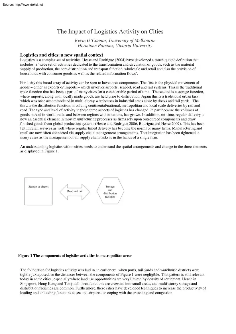
Source: http://www.doksinet The Impact of Logistics Activity on Cities Kevin O’Connor, University of Melbourne Hermione Parsons, Victoria University Logistics and cities: a new spatial context Logistics is a complex set of activities. Hesse and Rodrigue (2004) have developed a much quoted definition that includes a ‘wide set of activities dedicated to the transformation and circulation of goods, such as the material supply of production, the core distribution and transport function, wholesale and retail and also the provision of households with consumer goods as well as the related information flows’. For a city this broad array of activity can be seen to have three components. The first is the physical movement of goods – either as exports or imports – which involves airports, seaport, road and rail systems. This is the traditional trade function that has been a part of many cities for a considerable period of time. The second is a storage function, where imports, along
with locally made goods, are held prior to distribution. Again this is a traditional urban task, which was once accommodated in multi-storey warehouses in industrial areas close by docks and rail yards. The third is the distribution function, involving continental/national, metropolitan and local scale deliveries by rail and road. The type and level of activity in these three aspects of logistics has changed in part because the volumes of goods moved in world trade, and between regions within nations, has grown. In addition, on-time, regular delivery is now an essential element in most manufacturing processes as firms rely upon outsourced components and draw finished goods from global production systems (Hesse and Rodrigue 2006, Rodrigue and Hesse 2007). This has been felt in retail services as well where regular timed delivery has become the norm for many firms. Manufacturing and retail are now often connected via supply chain management arrangements. That integration has been
tightened in many cases as the management of all supply chain tasks is in the hands of a single firm. An understanding logistics within cities needs to understand the spatial arrangements and change in the three elements as displayed in Figure 1. Figure 1 The components of logistics activities in metropolitan areas The foundation for logistics activity was laid in an earlier era when ports, rail yards and warehouse districts were tightly juxtaposed, so the distances between the components of Figure 1 were negligible. That pattern is still relevant today in some cities, especially where land use opportunities are very limited by density of settlement. Hence in Singapore, Hong Kong and Tokyo all three functions are crowded into small areas, and multi-storey storage and distribution facilities are common. Furthermore, these cities have developed techniques to increase the productivity of loading and unloading functions at sea and airports, so coping with the crowding and congestion.
Source: http://www.doksinet In most cities however, these three components are subject to two pressures for change. The first is from residential gentrification which fuels opposition to 24-hour logistics activities, especially to high levels of truck traffic making the links between port or airport and the facilities of logistics firms. At the same time, some commercial redevelopment of old port land has reduced nearby opportunities for storage and delivery functions and can make day-to-day logistics activity more difficult. Paradoxically, most logistics activity is located in the commercially dominant global cities, as shown by O’Connor (2010). These are places with the most expensive commercial and residential land. That cost factor, along with the market benefits of being in these large cities, means that logistics services have had to look to the middle and outer suburbs, and beyond, to find space. A more fundamental pressure has come from the logistics industry itself, and is
expressed in the increased scale and shift in type of operation. As world trade expanded rapidly, larger ships and specialist air freight operators focused their services on a smaller number of hub sea- and airports which are now handling much greater volumes of goods than in the past. Within the storage and distribution function there has been a ‘re-invention of the warehouse’ (Bowen 2008) . This re-invention is expressed in ‘cross-docking’ which requires separate areas for arrival and dispatch of freight, with sorting – often electronically controlled – taking place within the building. Economies of scale of such an approach deem that very large buildings are required. In many cases these facilities are operated by third party logistics companies that coordinate inbound and outbound movements to suit client activity. In those operations, speed and flexibility is crucial, features that also require large-scale operation. The transport linkages have also expanded, and given
the shift in the storage and distribution function they have been felt in a major increase in truck traffic, and also an increase in the size of tracks used, especially as 40-foot containers became more common. When taken together the effect has been to stretch Figure 1 out from its original compact form. That outcome has been identified in Europe (Graham and Sahling 2004:3; Hesse and Rodrigue 2004) and in the US (Bowen 2008 and Cidell 2010). Very substantial logistics regions have emerged on the road systems on the outskirts of cities This outcome has been called ‘freight sprawl’ in the New York Metropolitan Region (de Cerreño et al 2008: 3; Rodrigue 2004), and can be seen in the vast expanse of new warehouse space in the inland empire east of Los Angeles (Mortimer 2008), which has generated substantial land use planning and urban management issues in that region (FHWA 2009). The outcome in England has attracted the ire of a Guardian columnist, who has labelled it ‘depot
sprawl’, seen as an ‘ugly blight’ on the post-industrial landscape. In some of these very large metropolitan areas a further extension of Figure 1 can be detected. The hinterlands of many ports and airports now follow long corridor alignments reflecting new connections with the port as Rodrigue (1994, 2004) has shown in Singapore and New York. Consultant research shows ‘distribution centres may be located 60– 70km away from ports, if sufficient transport connectivity is in place’ (CapGemini and Prologis 2006:31), while Rodrigue and Nottebaum (2008:13) identify an ‘extended gateway’ in an area of 100–150km around the port of Antwerp, and links extending over 100km around Rotterdam (Nottebaum and Rodrigue 2007:65). This review of research and practical examples shows that the logistics function has become a very spatially extensive activity in many metropolitan areas. These large spatial units can be seen as ‘ a new species of global city a 24 hour conveyance
urbanism of infrastructures, containers and specialized vehicles the global city as logistics city’ Easterling (2004:182). This functional and spatial outcome is, of course, taking place in a time period where the main emphasis of strategic planning in most metropolitan areas is one of urban consolidation, and in some places there is a physical restriction on development. Hence there is a tension between the way that a ‘conveyance urbanism’ operates and underlying strategic planning policies. The research shows how this new set of circumstances has been felt in Melbourne. Melbourne as a logistics centre A sectoral view The logistics role of Melbourne can be seen in a number of measures displayed below. First, the number of containers handled has grown 70 per cent over the decade shown here, and at over 2 million per year represent a daily movement of around 6,000 containers. Second the port remains the nation’s most significant, accounting for around a third of all movements.
Hence the pressure on the core infrastructure at the port has increased substantially, while transport links to and from the port will have expanded proportionately. Source: http://www.doksinet Figure 2 Container traffic at the Port Of Melbourne 2000–2010 Source: Ports Australia 2010 http://www.portsaustraliacomau/tradestats/ A second measure (Figure 3) shows Victoria has the highest number of articulated truck registrations in Australia. These trucks are important as they are long-haul freight trucks used for transporting goods to warehouses for further forwarding or to be broken up into smaller loads for distribution to retailers. Their presence confirms the importance attached to the distribution and delivery activity from Melbourne. More refined data could show change in the number of truck trips per day over the past decade. Figure 3 Number of articulated trucks registrations, selected states, 1982–2008 Source: Australian Bureau of Statistics – catalogue number 9309.0
Source: http://www.doksinet Finally, figure 4 shows data on warehouse construction. The investment in storage facilities has grown rapidly in the recent past, outstripping the investment in factories from the mid 1990s, as Australia’s manufacturing industry continues its relative decline in employment and imports of consumer goods, in particular, increase. This provides insight on the scale of growth of the distribution centres that handle not only imported goods, but locally produced products as well. It is the space needs of this activity, plus its truck-trip generation effects, that exert pressure on the spatial development and infrastructure requirements of a metropolitan area. Figure 4 Building approvals for industrial buildings (in 1990 dollars), Metropolitan Melbourne, 1984–2008 Source: State of Victoria, Urban Development Program, 2009 These measures show that Melbourne has a very strong role in logistics activities within Australia, and that role has been steadily
increasing in recent years. The next step is to explore the spatial outcomes of that role The spatial p erspective For the purposes of the current research a fundamental issue is the spatial configuration of this activity, and how that has changed over time. A set of figures that follow provides details on the spatial arrangement of logistics activity in metropolitan Melbourne. The key elements of the infrastructure for logistics in the metropolitan area are the centrally located seaport and the airport in the northwest, connected by the Western Ring Road passing major logistics land uses en route and linking to interstate road links to Adelaide and Sydney. There is also a freeway to the southeast industrial areas The port is close to the old inner city rail freight terminal, which has direct rail links to Sydney and Adelaide. The figure and table below provide two measures of the pattern of logistics activity that has emerged around this basic infrastructure. The first uses a GIS
technique to compress data on the location of employment in the census workforce category called ‘transport and storage’ into a spatial average; the analysis is repeated for the census years between 1981 and 2006. The data in Figure 5 shows the focus of employment in this industry sector is very clearly on the eastern side of the metropolitan area, and it has spread steadily over the time period displayed here. However it is also important to see that the rate of dispersal to the southeast has slowed since 1996, and especially between 2001 and 2006. That is no doubt due to the substantial logistics development associated with land made accessible by the Western Ring Road, which will be explored in more detail below. Source: http://www.doksinet Figure 5 The location of the average transport and storage job 1981–2006 Source: Davies, A.K (2009) The Structure of Suburban Employment in Melbourne PhD Thesis University of Melbourne. The measure of container loading and unloading in
sub-regions within the metropolitan area indicates that there are three main foci for that activity. These are the west, north and south; the western part of the metropolitan area accounts for the majority of the moves, and along with the northern region – both served by the Western Ring Road – account for over half the containers moved from the port in the metropolitan area. Table 1 Metropolitan origins and destinations of containers moving through the port of Melbourne Share of import and export Sub-region containers 13.6 Inner Melbourne 7.7 Outer eastern 19.3 Outer northern 24 Outer southeEast 35.4 Outer western 100 Total Source: Port Of Melbourne (2009) Using data on the sum of the value of building approvals between 2001 and 2009 it is apparent the west industrial node has had the majority of warehouse approvals and in that area warehouse building has been much more important that factory building, as seen in Table 2. The northern–airport zone is also important In
contrast, in the southern node, further from the port and airport, the value of warehouse approvals has been less, and here factory building is more prominent. The differences shown in this table probably account for much of the change seen in the location of the average job displayed in Figure 5. Source: http://www.doksinet Table 2 Value and proportion of value of warehouse and factory building approvals, industrial nodes 2001–2009 1 Value of warehouse approvals ($M) 1655.6 Warehouse approvals as a % of total industrial approvals 85% 290.9 Factory approvals as a % of total industrial approvals 15% 348.0 551.2 25% 47% 956.4 2146.5 39% 31% Value of factory approvals ($M) West node North and 2 1018.0 75% airport nodes 3 626.4 53% South node Remainder of Melbourne 1504.4 61% Total 4804.5 69% Source: Australian Bureau of Statistics (catalogue number 8731.0) 1 Local Government Areas of Brimbank, Hobsons Bay and Wyndham 2 Local Government Areas of Hume and Whittlesea 3 Local
Government Areas of Casey and Greater Dandenong A case study of a sample of uses in the West Industrial node confirms the special role that is emerging in that part of Melbourne. Details in Table 3 shows eight of the largest users in the case study are warehouses These warehouses are used by a range of industries including retailers, such as IGA and Aldi, and manufacturers, such as Murray Goulburn and Bonlac Foods as well as specialist logistics firms such as Toll. The second feature of these warehouses is their scale. In this sample they range in area from 105 hectares to approximately 5 hectares. To assist visualizing the size of these buildings, an international soccer pitch is approximately 0.7 hectare The development of these facilities in outer suburban Melbourne, close by the ring road, is entirely consistent with current US and European experience. Table 3 Average area of building footplates, industrial nodes, 1990–2009. Ten largest uses in the west industrial node, 2009
Name of Company Toyota Area (hectares) of building footplate(s) 22.3 IGA 10.5 Murray Goulburn 7.4 Woolworths 7.2 One Steel 6.7 Fosters Group 5.4 Aldi 5.1 Bonlac Foods 4.9 Linfox 4.9 Toll 4.9 Sources: Land Use Survey 2009 Industry of firm Type of land use Motor vehicle and part manufacturing Supermarket and grocery stores Dairy product manufacturing Supermarket and grocery stores Iron and steel manufacturing Beverage and malt manufacturing Supermarket and grocery stores Dairy product manufacturing Transport and storage Transport and storage Manufacturing plant Warehouse Warehouse Warehouse Manufacturing plant Warehouse Warehouse Warehouse Warehouse Warehouse These data confirm that in recent years the location of a significant part of logistics activity involved with inbound and export freight as well as regional and national distribution has become concentrated in the middle and outer fringe suburbs, on the western side of the metropolitan area, on land adjacent to
the Western Ring Road. In that outcome its experience is closely following that of metropolitan areas in the US and Europe. It is not clear at this stage whether there is sufficient land for the long-term needs of these Source: http://www.doksinet activities. The final section of the paper will explore some strategic planning issues that surround this outcome. Strategic urban planning issues for logistics activity The spatial outcomes in Melbourne outlined above suggest there are a series of major questions surrounding the incorporation of logistics activity into metropolitan strategic planning. The following section explores three issues that illustrate the scope of those questions, and review a current strategic response (State of Victoria 2008). Extend the established port and airport or build new facilities? A common approach here is to enhance and expand existing facilities as the sunk cost in the infrastructure at established sites is so substantial that the creation of new
facilities is financially problematic. Whether that is a good use of public funds – as it reinforces an established facility and may concentrate increased truck travel through established areas – or a misallocation as the industry needs a new and different approach in new locations, is a substantial strategic planning issue. Redeveloping established facilities can be seen in port cities such as Antwerp (van en Bergh et al 2005) and Hamburg (Wagner 2008), which both have ports embedded in the old city core, as well as for airports in London-Heathrow and Chicago. These have been accompanied by investments in facilities and processes to increase the productivity of the port or airport, and in some cases actions taken to facilitate movement of goods to and from the facility. In other cities new facilities have been built – a seaport in Shanghai, seaport extension in Singapore, and airports in Osaka, Denver, Bangkok and Hong Kong. For Melbourne, this issue has been addressed mainly by
intensifying the use of the port and airport facilities. For the port, there are plans to extend the dock area, and a channel deepening project undertaken to ensure the port can receive the larger vessels that are being used in sea trade. In a similar step, additional runway capacity was provided at the airport to allow the operation of the A380. The airport does not face the same short-term capacity concern. In addition to the runway decision it has embarked upon other infrastructure and capacity up-grades. As will be discussed below there is some consideration given to the longer term when new port facilities could be added at Westernport, and expanded facilities at Geelong, along with an expanded air transport role for Avalon. Pressure for actions along these lines may in fact emerge from issues associated with problems associated with connections to the port, and the location and growth of the storage and distribution facilities. Road and rail access: provide new infrastructure to
existing facilities, and/or distribute the load to freight centres? The extra throughput at the port, shown in Figure 1, seems to have been relatively easily achieved: larger ships, larger cranes and better coordination and management of the loading and unloading process has lifted port throughput. However, this increased number of outbound and inbound containers have to be moved into and from the port so that capacity limits on road and rail access begin to be felt. The pressure is not just absolute numbers but the conflicts involved in multi-use; road transport moving containers uses the same roads as the vehicles of the local community, while trains loaded with containers share track with local and regional passenger services. Trucks delivering to and from distribution centres face similar problems as they have to cross residential areas. Suburbs to the west of the port have felt this problem acutely Responses to this problem in other metropolitan areas include assignment of special
lanes for trucks, the use of larger scale multi-trailer trucks, and special hours of operation for freight trucks and trains. More fundamental action involves infrastructure investment to divert traffic from residential streets onto dedicated freight facilities. Two examples provide an idea of the way forward One is the Alameda Corridor (Hauswirth et al 2004, Yang 2008), connecting the Ports of Long Beach and Los Angeles with the centrally located rail terminals to allow onward transport to eastern US markets. This replaced a rail line that crossed a residential area. It was a very expensive, multi-agency project that put a two line rail link in a tunnel which allowed uninterrupted rail traffic between the port and the rail head and eliminated local land use conflicts. A second is the ‘Gateway Project’ in Vancouver (Government of British Columbia undated) This was designed to address commuter travel needs but also acknowledges ‘Metro Vancouver has also become an important gateway
for international trade and has emerged as Canada’s hub for Asia- Pacific trade. Over the last ten years, Port Metro Vancouver has seen increased trade with China and other countries Source: http://www.doksinet and that growth is expected to continue over the coming years’. The project has four spatial foci across the metropolitan region and includes road widening, new road construction, new bridges, and upgrading interchanges. One particular project is a ‘a new four-lane, 80 km/h route along the south side of the Fraser River . (to) provide a continuous and efficient route to serve the port facilities, rail yards and industrial areas along this key economic corridor, and will also benefit commuters’(Government of British Columbia (2003 no page numbers). To date the major infrastructure response in Melbourne has been the construction of the Western Ring Road. This was not built entirely for the movement of freight, but after its construction, very large scale investment in
warehouses and storage facilities took place in the western industrial node (in Table 1) and the spread of port-related deliveries to the west and the north is associated with this road access. Recent effort here has seen an additional lane added to the bridge. Similarly, improvements in access from the port to the rail yards has been put in place, partly via a dedicated road link, and also by connections to a new bridge built as part of a metropolitan toll road. In addition toll road construction across the metropolitan area has provided a multilane link between the centrally located port, and western airport, to the industrial and storage and distribution facilities in the southeast. Finally rail freight facilities have been developed in the vicinity of the docks, but require road transport transfers rather than direct on to rail loading. The current strategic response involves the creation of a metropolitan freight terminal network, with more capacity, and greater dispersal of
activity, as well as special attention to the problems of truck traffic in the ‘last kilometre’. The essence of the approach is to move freight out of the central port area to specially designed facilities in suburban and even regional locations. This approach is expressed in the idea of ‘freight centres’ which has a long history (Slack 1999), and applications can be found in as places as diverse as cities in Italy (Iannone et al 2007) and in New York (de Cerreño et al 2008). This approach is often based on the use of rail transport for the initial move, on the grounds that bulk movements by rail offer economic and environmental benefits over many single moves by truck. Bryan et al (2007) show that these benefits but caution that they depend on a number of features including length of movement, density of traffic and also local regulatory structures. To be effective it requires dedicated rail track. If trucks are to be used for the initial moves it will be necessary to have
dedicated truck lanes to get the benefit of the approach, especially if higher capacity vehicles are to be used. It also requires space for storage and handling facilities in the freight centre itself, which might mean locating the freight centre beyond the current urban fringe, as only there will sufficient space be available. Hence an effective implementation calls for a major infrastructure investment. The Melbourne strategy recognizes the continuation of the role of the Port of Melbourne, with additional handling capacity, along with three potential freight centres, two – north and west – associated with the major infrastructure of the seaport, airport, Western Ring Road and Adelaide and Sydney rail lines. The third centre is in the southeast, located to link to the established industrial and warehouse and storage activity in that part of the metropolitan area. The first two centres have rail access to the port as they are on corridors served by freight trains. They would
require investment in sidings and loading and unloading facilities The southeast centre has a complicated rail connection to the port, involving travel through the CBD. It is however linked to the port and airport by freeway, and recently a freeway on a north–south axis was built in that part of the metropolitan area, so widening its potential service area. In summary the freight centre approach is yet to be developed in concrete terms in Melbourne. Land for storage and distribution: where and how much? Changes in the location of the storage and distribution activity require attention to land use zoning policy, and also long-term controls to ensure space will be available. Overseas experience suggests that development has been ad hoc, driven by market demand in convenient locations. That outcome can be seen in case studies of distribution centres in the far eastern part of the Los Angeles metropolitan area, as well as across a series of diverse locations in the UK, as well as around
major European cities. However, systematic understanding of the forces driving demand, and the potential supply requirements over a longer term, seem yet to be developed. In Melbourne, the foundation for this approach is laid in the monitoring of industrial land supply and demand. Recent analysis, as displayed in Table 1, shows a steady rate of consumption which begs two questions: ‘How much land do we need?’ and ‘Where will the next generation space be available?’. Approaches to the first question tend to be an extension of techniques for projecting the demand for land for manufacturing. This is generally a simple modification of population projections, utilizing assumptions that a given population requires a specified amount of industrial land. Refinement of these approaches is needed, Source: http://www.doksinet with specific attention to logistics land uses, which will be tied to trade activity and industry organizational arrangements in addition to population trends.
Attempting to answer the second question involves an intersection with residential land development policy which in many cities is designed to limit urban expansion, and is justified on a range of grounds. However it is not clear whether storage and distribution centres, and maybe the freight centres discussed earlier, qualify as uses allowed beyond the urban growth boundary. From one perspective they are not residential activities, and so may not be subject to growth boundary controls. Alternatively it could be seen that the jobs associated with these facilities would stimulate more residential development in fringe locations, and so put pressure on growth boundary locations, and so be prohibited. It is possible that this approach could stimulate some more intensive use of storage and distribution land, although in the longer term land scarcity could drive the activity further out. This element of the urban planning for logistics is perhaps the least developed policy area. Yet
several of the issues facing logistics development will call for additional land, or maybe land in different locations. Ensuring that land is available, in places served at least by road, and preferably by rail as well, will be a major challenge, especially in growing cities. Recognition of that challenge has led some strategic planning efforts to widen their focus of attention. Do we need a larger area for long-term planning? It has become common to think about strategy for logistics operation on a mega city scale. Although formal planning action has not been applied in many places in this way, some general frameworks have been developed to outline the longer term future and so set priorities for infrastructure decisions. One approach involves collaboration between infrastructure agencies which is emerging among Asian ports, for example (Cullinane and Song 2007). The coordination of a number of previously separate ports into one organization in Vancouver provides a concrete example
of the approach (Ginnell et al 2008). The larger scale perspective relates to the idea of inland freight centres. Their location and potential role will depend on available transport infrastructure. Some of this thinking was applied to construct the Virginia Inland Port which is served by rail connections from the port of Hampton Roads, and was built close to the interstate road system to facilitate onward movement and collection. In Europe, the Government of Flanders uses the concept of an ‘Extended Gateway’ to develop connections between Antwerp and inland freight centres (Government of Flanders undated). The larger spatial framework has been part of thinking for Melbourne for some time. This triggered by the fact that the original port facility may face limitations in the long term and is not well connected to the longestablished population concentration – and continued growth – in the southeast. Added to that there is an existing port facility in the southeast. As noted
earlier, space and operational limitations are unlikely to be felt at the airport, which has been protected by buffer zones, and limits on land development on airline approach paths. However, a second airport does exist in the larger metropolitan region and is currently used by some low-cost carriers. It could perform an expanded role as a specialized freight facility If these additional facilities were developed it will be necessary to add capacity for cross- regional movement by rail and road. That could involve completing a ring road, or in other ways providing a second east–west crossing. It is likely, too, that additional capacity will be needed in the north and west along the lines of the freight centres mentioned earlier. Even larger spatial visions bring towns across rural Victoria into focus, especially those on interstate road and rail links. Implementing that vision will require substantial upgrading – and additional capacity – on the rail system, and probably more
capacity in some parts of the road links. Given the distances involved this will be expensive. Implementing a strategy for logistics The circumstances outlined above illustrate that the three broad elements of logistics activity are interdependent and strategic planning solutions need to address them as a set of interrelated functions. The thinking that has been applied in Melbourne suggests there is a coherent industry stakeholder vision on a number of alternative strategic actions. Moving from that perspective to an implementable strategy faces a number of key issues. First, notwithstanding a perceived stakeholder common view, governance arrangements are fragmented. Separate authorities are responsible for port and airport facilities – and other firms handle their day-to-day operations. Road transport construction is managed by a state agency as well as a private toll road operator Source: http://www.doksinet Rail transport is a separate part of government – and also includes
private operators. Land use regulations are set by state agencies but applied by local government, while end users of port, airport and storage and distribution centres are all private sector firms. Second, it is not clear how the strategic ideas for logistics development will be linked to the broader land use strategy for the metropolitan area. In the metropolitan strategy adopted in 2002 (State of Victoria 2002) logistics were addressed via Direction 4.3: Further develop the key transport gateways and freight links and maintain Victoria’s position as the nation’s premier logistics centre. This directed attention to the protection of the key infrastructure assets, and indicated detailed strategic attention was needed and that a logistics plan would be developed. That was published as Freight Futures Victorian Freight Network Strategy for a more prosperous and liveable Victoria (State of Victoria (2008). The metropolitan strategy is currently under review. However, recent
statements on the immediate future of urban policy for Melbourne include intensification of residential development in land close by the port. This may place some limits on port operations. The potential tension between land development for logistics uses and the controls involved in the urban growth boundary has been mentioned. Additional rail capacity to move freight out of the port area will require capacity that is currently taken largely by suburban passenger services. That set of tensions illustrates that articulating strategic policy to accommodate logistics activity is fraught with conflicting priorities. Those tensions will remain under a business-as-usual situation, which relies on road transport to move a rising level of freight, which will require further dispersal of distribution centres beyond their current locations, following the freeways out to and beyond the fringe. Interrupting this scenario will require very substantial transport infrastructure investment. Funding
there will need to compete with projects designed for commuter traffic. One key concern here is that strategic planning has given little thought to predicting the likely long-term need for land for logistics services. Without that information it will be very difficult to develop an approach to accommodate the activities that are central to Melbourne’s international and national role, and make it difficult to incorporate that approach into the broader strategic framework for the metropolitan area. References Australian Bureau of Statistics (n.d) catalogue number 93090 van den Bergh, E., van Damme, S, Graveland, J, de Jong, D, Baten, I, and Meire, ,P (2005) Ecological Rehabilitation of the Schelde Estuary (The Netherlands–Belgium; Northwest Europe): Linking Ecology, Safety Against Floods, and Accessibility for Port Development, Restoration Ecology, 13, 204–10. Bowen, J. (2008) Concentration and decentralization: The new geography of freight distribution in US metropolitan areas,
Journal of Transport Geography, 16, (6) 379–87 Bryan, J., Weisbrod, G and Martland, CD (2007) Rail Freight as a Means of Reducing Roadway Congestion: Feasibility Considerations for Transportation Planning Transportation Research Record: Journal of the Transportation Research Board No. 2008 Washington, DC Transportation Research Board of the National Academies. page 75–83 CapGemini and Prologis (2006) Warehousing space in Europe: meeting tomorrow’s demand. http://www.decapgeminicom/m/de/tl/Warehousing space in Europe meeting tomorrow s de mandpdf de Cerreño, A.LC, Shin, H-S, Strauss-Wieder, A and Theofanis, S (2008) Feasibility of Freight Villages in the NYMTC Region. Center for Advanced Infrastructure and Transportation Freight and Maritime Program Rutgers, The State University of New Jersey and NYU Rudin Center for Transportation and Management. Cidell, J. (2010) Moving places: the Geography of Warehousing in the US, Journal of Transport Geography, 18 (3), 363–71 Cullinane,
K., and Song, D-W (eds) (2007) Asian Container Ports Development, Competition and Cooperation Basingstoke, UK Palgrave McMillan Source: http://www.doksinet Davies, A.K (2009) The Structure of Suburban Employment in Melbourne PhD Thesis University of Melbourne. Easterling, K (2004) The New Orgman: Logistics as an Organising Principle of Contemporary Cities, in Graham, S (ed) The Cyber Cities Reader. London Routledge, pp 179–84 Federal Highway Administration Office of Freight Management and Operations (2009) Southern California Regional Freight Study http://ops.fhwadotgov/freight/freight analysis/reg ind studies/so cal studyhtm Ginnell, K., Smith, P and Oberlander, HP (2008) Making Biggest Bigger: Port Metro Vancouver’s 21st Century Re‐ Structuring – Global Meets Local at the Asia Pacific Gateway Canadian Political Science Review 276‐ 92 Graham, L., and Sahling, L(2004) European Warehouse Market Research Overview of Pan European Trends. Amsterdam Prologis Government of
British Columbia (2003) Gateway Program. http://wwwgatewayprogrambcca/ Government of Flanders (undated) The Logistics Industry in Flanders. http://www.flanderstradecom/appl/communicatiensf/2159C2BA6E3300D9C12576E8002C29F6/$Fil e/LogisticsFlan ders.pdf Hauswirth, D.B, Hoffman, DW, Kane, JW, Ozobu, IL Thomas, CL and Wong, PW (eds) (2004) Alameda Corridor, in Collaborative Leadership: Success Stories in Transportation Mega Projects, US Department of Transport, Federal Highway Administration, pp. 37–43 http://www.fhwadotgov/ipd/pdfs/collaborativepdf Hesse, M. (2008) The city as a terminal: the urban context of logistics and freight transport Burlington Vt., Ashgate Hesse, M., and Rodrigue, J-P (2004) The Transport Geography of Logistics and Freight Distribution, Journal of Transport Geography, 12, 3 Hesse, M., and Rodrigue, J-P (2006) Global production networks and the role of Logistics and Transportation, Growth and Change 37, 499-509. Hunt, T. (2006) Warehouse of the world: out-of-town
depots are an ugly blight on the landscape and will destroy our civic life. The Guardian, July 12, Page 32 Iannone, F., Thore, S and Forte, E (2007) Inland container logistics and interports Goals and features of an ongoing applied research, Italian Society of Transport Economists – Ninth Meeting – Naples, October 3-5, 2007 Mortimer, L.S(2008) Import Slowdown Affecting Warehouse Demand in the Largest Port Markets CBRE Torto Wheaton Research Industrial Outlook 8 (2) January 11, 2008 Notteboom, T., and Rodrigue, J-P (2004) Inland Freight Distribution and the Sub-harborization of Port Terminals http://people.hofstraedu/Jean-paul Rodrigue/downloads/ICLSP-%20Notteboom-Rodriguefinal%20versionpdf Notteboom, T. and Rodrigue, J-P( 2007) Re-Assessing Port-Hinterland Relationships in the Context of Global Commodity Chains, in Wang, J., Olivier, D, Notteboom,T and Slack, B (eds) Ports, Cities, and Global Supply Chains Ashgate, pp. 51–68 O’Connor, K. (2010) Global City Regions and the
Location of Logistics Activity, Journal of Transport Geography Port of Melbourne (2010) Port of Melbourne and Dynon Rail Terminals 2009 Container Logistics Chain Study Rodrigue, J-P. (1994) ‘Transportation and Territorial Development in the Singapore Extended Metropolitan Region’, Singapore Journal of Tropical Geography, 15, 56–74 Source: http://www.doksinet Rodrigue, J-P. (2004) Logistics, Gateways And Mega-Urban Regions: The Logistical Integration Of The Bostwash Corridor, Tijdschrift voor Economische en Sociale Geografie, 95, 147–61 Rodrigue, J-P. and Hesse, M (2007) Globalised Trade and Logistics: North American Perspectives, in Leinbach, T.R and Capineri, C (eds) Globalised Logistics Transport Intermodality, E-Commerce, Logistics and Sustainability. Cheltenham, UK, Edward Elgar, pp 103–34 Rodrigue, J-P. and Nottebaum, T (2008) The Terminalization of Supply Chains IAME 2008 Conference – Dalian, China 2-4 April 2008 http://people.hofstraedu/jean-paul rodrigue/cv
publicationshtm Accessed August 2, 2008 Slack, B. (1999) Satellite terminals: a local solution to hub congestion? Journal of Transport Geography, 7, 241–46 State of Victoria (2002) Melbourne 2030. Department of Sustainability and Environment http://www.nrevicgovau/melbourne2030online/content/introduction/02 summaryhtml State of Victoria (2008) Freight Futures. Victorian Freight Network Strategy for a more prosperous and liveable Victoria. http://www.transportvicgovau/doi/doielectnsf/2a6bd98dee287482ca256915001cff0c/612a49cebbe e70a1ca257521002095fa/$FILE/freightfutures.pdf State of Victoria (2009) Department of planning and Community Development. Urban Development Program Annual Report: Industrial Land. http://wwwdpcdvicgovau/planning/plansandpolicies/urbandevelopment-program/udp-annual- report-2009/udp-annual-report-2009-industrial-land