Datasheet
Year, pagecount:2007, 3 page(s)
Language:English
Downloads:2
Uploaded:January 18, 2018
Size:460 KB
Institution:
-
Comments:
Attachment:-
Download in PDF:Please log in!
Comments
No comments yet. You can be the first!Most popular documents in this category


Content extract
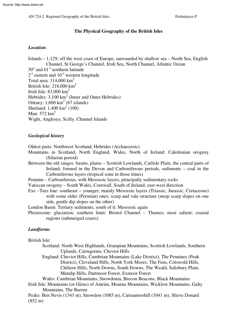
Source: http://www.doksinet AN 724-2 Regional Geography of the British Isles Dolmányos P. The Physical Geography of the British Isles Location: Islands – 1,129; off the west coast of Europe, surrounded by shallow sea – North Sea, English Channel, St George’s Channel, Irish Sea, North Channel, Atlantic Ocean 50o and 61 o northern latitude 2 o eastern and 10 o western longitude Total area: 314,000 km2 British Isle: 218,000 km2 Irish Isle: 83,000 km2 Hebrides: 3,100 km2 (Inner and Outer Hebrides) Orkney: 1,600 km2 (67 islands) Shetland: 1,400 km2 (100) Man: 572 km2 Wight, Anglesey, Scilly, Channel Islands Geological history Oldest parts: Northwest Scotland, Hebrides (Archaeozoic) Mountains in Scotland, North England, Wales, North of Ireland: Caledonian orogeny (Silurian period) Between the old ranges: basins, plains – Scottish Lowlands, Carlisle Plain, the central parts of Ireland; formed in the Devon and Carboniferous periods, sediments – coal in the Carboniferous layers
(tropical zone in those times) Pennine – Carboniferous, with Mesozoic layers, principally sedimentary rocks Variscan orogeny – South Wales, Cornwall, South of Ireland; east-west direction Exe –Tees line: southeast – younger; mainly Mesozoic layers (Triassic, Jurassic, Cretaceous) with some older (Permian) ones; scarp and vale structure (steep scarp slopes on one side, gentle dip slopes on the other) London Basin: Tertiary sediments, south of it: Mesozoic again Pleistocene: glaciation; southern limit: Bristol Channel – Thames; most salient: coastal regions (submerged coasts) Landforms British Isle: Scotland: North West Highlands, Grampian Mountains, Scottish Lowlands, Southern Uplands, Cairngorms, Cheviot Hills England: Cheviot Hills, Cumbrian Mountains (Lake District), The Pennines (Peak District), Cleveland Hills, North York Moors, The Fens, Cotswold Hills, Chiltern Hills, North Downs, South Downs, The Weald, Salisbury Plain, Mendip Hills, Dartmoor Forest, Exmoor Forest
Wales: Cambrian Mountains, Snowdonia, Brecon Beacons, Black Mountains Irish Isle: Mountains (or Glens) of Antrim, Mourne Mountains, Wicklow Mountains, Galty Mountains, The Burren Peaks: Ben Nevis (1343 m), Snowdon (1085 m), Carrauntoohill (1041 m), Slieve Donard (852 m) Source: http://www.doksinet AN 724-2 Regional Geography of the British Isles Dolmányos P. 2 Climate Location: temperate zone (northern), marine climate area Air masses: Northwest: polar maritime (cold, moist) North: arctic maritime (very cold, moist; in winter) Northeast: polar continental (very cold, dry; in winter) Southwest: tropical maritime (warm, moist) South: tropical continental (hot, dry) Westerlies, islands – much precipitation, evenly distributed; close to Iceland (Icelandic low) – stormy weather North Atlantic Drift: mean annual temperature 7-8 oC warmer than on the same latitude Britain: Mean annual temperature: 7-11 oC Mean maximum temperature: 13-18 oC (Orkney, Shetland: 11 oC) Mean minimum
temperature: 3-7 oC Temperature extremes: Highest: 38.5 oC (Brogdale, Kent; August 10, 2003) Lowest: - 27.2 oC (Braemar, Scotland, January 10, 1982; Altnaharra, Scotland, December 30, 1995) Precipitation: 600 to 1500 mm (extremes: 553 mm in Cambridge; 2-4000 mm in Scottish Highlands) Amount of sunshine: 900 to 1,750-2,100 (Hebrides to Southeast) Fog, more than 50% of the days overcast Ireland: Mean maximum temperature: 14-16 oC Mean minimum temperature: 4-7 oC Precipitation: 700-1400 mm (60% of it between August and January) Hydrology Seas Abundant precipitation – lots of rivers; even water level, high water output; many small rivers with small drainage basins; no freezing even in winter Estuaries Canals – altogether 7,500 km of inland waterways Rivers: Britain: Thames – 338 km, 16,000 km2; Severn – 354 km; Mersey, Tyne, Tees, Clyde, Avon, Trent Ireland: Shannon (longest: 386 km; largest drainage basin), Barrow, Boyne, Lagan, Bann, Liffey Lakes: Scotland, Ireland, Lake
District; largest: Lough Neagh (38 km2) Moors and bogs Source: http://www.doksinet AN 724-2 Regional Geography of the British Isles Dolmányos P. 3 Natural vegetation Originally: deciduous forests – beech and oak (limit: Scotland: 300 m, England: 500 m); marshlands, bogs Forests: < 5% South: evergreens (no frost) Soils Southeast: brown forest soils; other: forest soils, alluvial soils, podzol Ireland: south and east – brown forest soils and podzols; north and west – peats, gleys and podzols Appendix: The geological time scale Era Period Epoch Holocene Quaternary Cainozoic Tertiary Mesozoic Palaeozoic Cretaceous Jurassic Triassic Permian Carboniferous Devonian Silurian Ordovician Cambrian Pleistocene Pliocene Miocene Oligocene Eocene Palaeocene Duration Million in million years ago years (12,000 years ago) 2.4 2.4 5.5 7 19 26 12 38 16 54 11 65 71 136 54 190 35 225 55 280 65 345 50 395 35 430 70 500 70 570 Precambrian Proterozoic Archeozoic (Source: Clark, A. N
The New Penguin Dictionary of Geography Harmondsworth: Penguin, 1990. p 131)
 When reading, most of us just let a story wash over us, getting lost in the world of the book rather than paying attention to the individual elements of the plot or writing. However, in English class, our teachers ask us to look at the mechanics of the writing.