Datasheet
Year, pagecount:2017, 1 page(s)
Language:English
Downloads:1
Uploaded:February 28, 2019
Size:1 MB
Institution:
-
Comments:
Attachment:-
Download in PDF:Please log in!
Comments
No comments yet. You can be the first!


Content extract
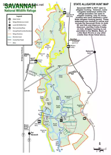
,. J Source: http://www.doksinet SAVANNAH National Wildlife Refuge . l -•-•~ / O i=J E!I ,. RefugeMaintenanceCenter l LaurelHillWildlifeDrive ,~ r.ou Rd 110 Bec~Ferry ~ j i :::il i J ) BoatlaunchingRamp • (° ,~ p .f:J"o/ Georgia/SouthCarolinaBoundary - ci-, , j,y ;) VisltorCenter 8 ~:. RefugeBoundary STATE ALLIGATOR HUNT MAP ~ . (" Legend {:, . ;, """· / Savannah NWR 1s NOT open to alhgator huntmg However, some nav1gable waterways w1thm the refuge boundary are open to alhgator huntmg, only for those S~~t~t=~~g~~ir i~vn~1~~t~~r~1: ~~~~e waterways are marked m yellow and mclude the Savannah R1ver (m both SC and GA) and Abercorn , Little Abercorn, and Big Collis Creeks (in GA). Alligator hunting is not 1 Ptft~:~~d~ ~~=e~dir : •n~~~~•e~r creeks than those listed above. DiversionCanal ( County/StateP.oads Dikes j ;• i SolomooTract , ,.~ l j Frpnt i Ríver,,,• Is/a • Island ) / / Miefd/e
Rivor Ste.9 • -tr%. HousloMl 1· -2. ~1rt 1 ~ "" r--. N
Rivor Ste.9 • -tr%. HousloMl 1· -2. ~1rt 1 ~ "" r--. N