Comments
No comments yet. You can be the first!
Most popular documents in this category


Content extract
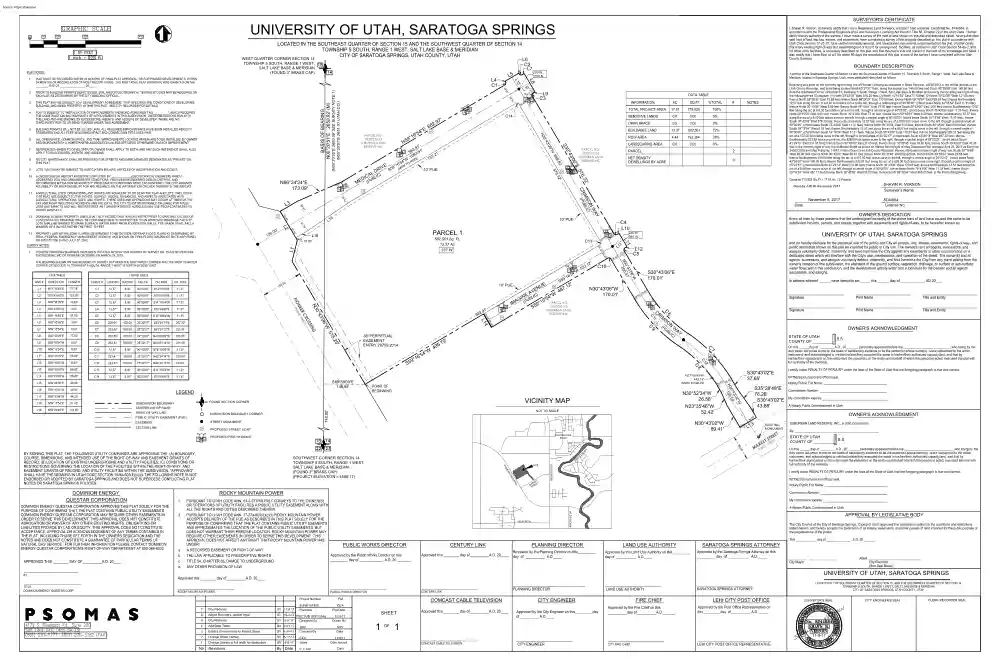
SURVEYOR'S CERTIFICATE UNIVERSITY OF UTAH, SARATOGA SPRINGS I, Shawn R. Vernon, do hereby certify that I am a Registered Land Surveyor, and that I hold a license, Certificate No 8744084, in accordance with the Professional Engineers and Land Surveyors Licensing Act found in Title 58, Chapter 22 of the Utah Code. I further certify that by authority of the owners, I have made a survey of the tract of land shown on this plat and described below, have subdivided said tract of land into lots, streets, and easements, have completed a survey of the property described on this plat in accordance with Utah Code Section 17-23-17, have verified all measurements, and have placed monuments s represented on the plat. I further certify that every existing right-of-way and easement grant of record for underground facilities, as defined in Utah Code Section 54-8a-2, and for other utility facilities, is accurately described on this plat, and that this plat is true and correct to the best of my
knowledge and belief. I also certify that I have filed, or will file within 90 days the recordation of this plat, a map of the survey I have completed with the Utah County Surveyor. LOCATED IN THE SOUTHEAST QUARTER OF SECTION 15 AND THE SOUTHWEST QUARTER OF SECTION 14 TOWNSHIP 5 SOUTH, RANGE 1 WEST, SALT LAKE BASE & MERIDIAN CITY OF SARATOGA SPRINGS, UTAH COUNTY, UTAH WEST QUARTER CORNER SECTION 14 PLAT NOTES: 3'0 0°4 10' PUE ' L1 337 W. 12.57' 8.00' 90°00'00" N14°16'54"E . 150 6 9°1 11.31' N30°43'06"W 121.00' C2 12.57' 8.00' 90°00'00" S75°43'06"E 11.31' L3 N59°38'35"E 72.69' C3 12.57' 8.00' 90°00'00" S14°16'54"W 11.31' L4 N30°43'06"W 3.00' C4 12.57' 8.00' 90°00'00" S75°43'06"E 11.31' N59°16'54"E 8.00' C7 233.82'
528.00' 25°22'21" S43°24'12"E 231.91' L8 S30°43'06"E 77.00' C8 200.55' 472.00' 24°20'42" N43°55'02"W 199.05' L9 S59°16'54"W 8.50' C9 233.81' 528.00' 25°22'17" N43°24'14"W 231.90' L10 N59°16'54"E 8.33' C10 12.57' 8.00' 90°00'00" N75°43'06"W 11.31' L11 S30°43'06"E 56.00' C11 221.41' 500.00' 25°22'17" N43°24'14"W 219.60' L12 S59°16'54"W 8.33' C12 221.42' 500.00' 25°22'21" N43°24'12"W 219.61' L13 S59°16'58"W 69.00' C13 12.57' 8.00' 90°00'00" S14°16'54"W 11.31' L14 N30°43'06"W 56.00' C14 12.57' 8.00' 90°00'00" S75°43'06"E 11.31' L15
S30°43'06"E 49.50' L16 S59°16'54"W 44.50' L17 S59°16'54"W 44.33' L18 N59°16'54"E 51.45' L19 N55°26'40"E 174.65' 9 30' PERPETUAL EASEMENT ENTRY 28759:2014 PARCEL 2 NET DENSITY DEWELLINGS BY ACRE 0 ' 2 7.1 48 LEGEND SUBDIVISION BOUNDARY CENTERLINE OF ROAD FOUND SECTION CORNER RIGHT OF WAY LINE SUBDIVISION BOUNDARY CORNER STREET MONUMENT EASEMENT LP 7 L1 C10 LP ' .00 28 N30°43'06"W 170.01' S30°43'06"E 170.01' In witness whereof have hereunto set this day of , AD 20 0' 8.0 '2 .00 28 CR I LP (P N UB LI Title and Entity Signature Print Name Title and Entity OWNER'S ACKNOWLEDGMENT W C) AY STATE OF UTAH S.S COUNTY OF On this day of A.D, 20 , personally appeared before me, , who being by me duly sworn did
prove to me on the basis of satisfactory evidence to be the person(s) whose name(s) is/are subscribed to the within instrument, and acknowledged to me that he/she/they executed the same in his/her/their authorized capacity(ies), and that by his/her/their signature(s) on the instrument the person(s), or the entity upon behalf of which the person(s) acted, executed this plat with full authority of the owner(s). C N37°45'43"W 442.13' (MON TO MON) POINT OF BEGINNING ' ' .00 .00 28 28 N30°52'34"W 26.58' N23°35'46"W 52.42' NOT TO SCALE I certify under PENALTY OF PERJURY under the laws of the State of Utah that the foregoing paragraph is true and correct. S30°43'02"E 37.65' WITNESS my hand and official seal. Notary Public Full Name: S35°28'48"E Commission Number: 78.28' S30°43'02"E My commission expires: A Notary Public Commissioned in Utah 43.88' OWNER'S ACKNOWLEDGMENT
' .50 34 N30°43'02"W 89.41' LP 3 L1 R .00 89 ET ) ETSTREET K R C MA(PUBL I VO RI VE EXISTING MONUMENT E STR CROSSROADS BLVD SITE ER NE G SIN OS CR ET RK T MA REE T S REDWOOD RD N0°20'51"E 740.00' PR O SOUTHWEST CORNER SECTION 14 TOWNSHIP 5 SOUTH, RANGE 1 WEST, SALT LAKE BASE & MERIDIAN (FOUND 3" BRASS CAP) (PROJECT ELEVATION = 4568.17) ROCKY MOUNTAIN POWER Print Name SO 9' 7 . 5 49 PIO DOMINION ENERGY QUESTAR CORPORATION Signature M PROPOSED STREET LIGHT BY SIGNING THIS PLAT, THE FOLLOWING UTILITY COMPANIES ARE APPROVING THE: (A) BOUNDARY, COURSE, DIMENSIONS, AND INTENDED USE OF THE RIGHT-OF-WAY AND EASEMENT GRANTS OF RECORD; (B) LOCATION OF EXISTING UNDERGROUND AND UTILITY FACILITIES; (C) CONDITIONS OR RESTRICTIONS GOVERNING THE LOCATION OF THE FACILITIES WITHIN THE RIGHT-OF-WAY, AND EASEMENT GRANTS OF RECORD, AND UTILITY FACILITIES WITHIN THE SUBDIVISION. "APPROVING" SHALL HAVE THE
MEANING IN UTAH CODE SECTION 10-9A-603(4)(c)(ii). THE FOLLOWING NOTE IS NOT ENDORSED OR ADOPTED BY SARATOGA SPRINGS AND DOES NOT SUPERCEDE CONFLICTING PLAT NOTES OR SARATOGA SPRINGS POLICIES: License No. and do hereby dedicate for the perpetual use of the public and City all parcels, lots, streets, easements, rights-of-way, and public amenitites shown on this plat as intended for public or City use. The owner(s) and all agents, successors, and assigns voluntarily defend, indemnify, and save harmless the City against any easements or other encumbrance on a dedicated street which will interfere with the City's use, maintenance, and operation of the street. The owner(s) and all agents, successors, and assigns voluntarily defend, indemnify, and hold harmless the City from any claim arising from the owner's creation of this subdivision, the alteration of the ground surface, vegetation, drainage, or surface or sub-surface water flows within this subdivision, and the development
activity within this subdivision by the owners and all agents, successors, and assigns. L12 C5 LP PROPOSED FIRE HYDRANT 8744084 UNIVERSITY OF UTAH, SARATOGA SPRINGS VICINITY MAP PUBLIC UTILITY EASEMENT (PUE) SHAWN R. VERNON Know all men by these presents that the undersigned owner(s) of the above tract of land have caused the same to be subdivided into lots, parcels, and streets, together with easements and rights-of-way, to be hereafter known as: 9 S5 S89°39'09"E 148.98' SECTION LINE 4"W 5 ' °16 0% 2"W 3'0 ' 0°4 .54 N3 159 L7 0.00 LP 207.30' 0.0 7 25°22'17" S43°24'14"E LANDSCAPING AREA 8 472.00' 28% 2 C1 209.01' 193,364 C C6 4.44 C6 3.00' ROW AREA C9 S30°43'06"E 72% 1 C1 L6 582,561 ' 11.31' 13.37 .00 90°00'00" S14°16'54"W BUILDABLE LAND RESERVE INC 4 8.00' 0% ' 28 12.57' L1 C5 1' .9
82 .00 57.00' 4"W 2' 52 ) E 4"W IN BLIC 5 ' G U 6 A NO. IM (P 59°1 PARCEL 58:032:0163 S SUBURBAN LAND 28 N59°16'54"E 5' L5 LP AV 5.2 51 6"W 3'0 G 0°4 N3 SIN OS CR ET) ER STRE NE BLIC PIO (PU L2 S5 UE EN 10' PUE 740.00' C1 00' CH. DIST 0.00 6"W 3'0 ' 0°4 .01 N3 206 '5 CH. BRG 0.0 245 W. 990 N. ' ' 00 .00 28 8 2 ' 77.78' DELTA OPEN SPACE C4 L10 .00 N14°16'54"E CURVE # LENGTH RADIUS 0% OWNER'S DEDICATION ' 28 L1 3.1 CURVE TABLE DIRECTION LENGTH 0.00 November 8, 2017 .00 LINE # 0.0 1 L1 C13 THE BEARING SHOWN ON SAID RECORD OF SURVEY BETWEEN THE SOUTHWEST CORNER AND THE WEST QUARTER CORNER OF SECTION 14, TOWNSHIP 5 SOUTH, RANGE 1 WEST IS NORTH 00°20'55" EAST. LINE TABLE SENSITIVE LANDS Date 28 PIONEER CROSSING BEARINGS HAVE BEEN ROTATED 00°00'04" PER RECORD OF SURVEY NO. 15-032 BY
MERIDIAN ENGINEERING, INC OF PIONEER CROSSING ON MARCH 18, 2015. 100% Surveyor's Name ' .19 582,561 Sq. Ft 13.37 Ac 10.00' 775,925 NOTES Cked by JJB 06 November 2017 .19 50 50 L2 PARCEL 1 L18 TOTAL PROJECT AREA 17.81 # Contains 775,925 Sq. Ft / 1781 Ac / 2 Parcels Y WA N 2' MSO LIC) B I CR (PU L1 ' ' .00 %TOTAL 6.3 ' 9 0 13 13. PROPERTY LIES WITHIN ZONE X, (AREA DETERMINED TO BE OUTSIDE 500-YEAR FLOOD PLAIN) AS DETERMINED BY FEMA (FEDERAL EMERGENCY MANAGEMENT AGENCY) AND SHOWN ON FIRM (FLOOD INSURANCE RATE MAP) PANEL NO 4955170115B DATED JULY 17, 2002. SURVEY NOTES: SQ FT 57 .50 ' .97 59 LP PARCEL NO. 58:032:0163 SUBURBAN LAND RESERVE INC 6"E ' LP .43 60 12. DRAINAGE ACROSS PROPERTY LINES SHALL NOT EXCEED THAT WHICH EXISTED PRIOR TO GRADING EXCESS OR CONCENTRATED DRAINAGE SHALL BE CONTAINED ON SITE OR DIRECTED TO AN APPROVED DRAINAGE FACILITY. LOTS SHALL BE GRADED TO DRAIN SURFACE WATER AWAY FROM
FOUNDATION WALLS. THE GRADE SHALL FALL A MINIMUM OF 6 INCHES WITHIN THE FIRST 10 FEET. 1. .50 L3 AC LP 38 11. AGRICULTURAL USES, OPERATIONS, AND RIGHTS ARE ADJACENT TO OR NEAR THE PLAT AND LOTS THE LOTS IN THIS PLAT ARE SUBJECT TO THE SIGHTS, SOUNDS, ODORS, NUISANCES, AND ASPECTS ASSOCIATED WITH AGRICULTURAL OPERATIONS, USES, AND RIGHTS. THESE USES AND OPERATIONS MAY OCCUR AT TIMES OF THE DAY AND NIGHT INCLUDING WEEKENDS AND HOLIDAYS. THE CITY IS NOT RESPONSIBLE OR LIABLE FOR THESE USES AND IMPACTS AND WILL NOT RESTRICT ANY GRANDFATHERED AGRICULTURAL USE FROM CONTINUING TO OCCUR LAWFULLY. 10' PUE C I DI UBL E M (P 38 N66°24'24"E 173.09' S3 10. A GEOTECHNICAL REPORT HAS BEEN COMPLETED BY [GEOTECHNICAL ENGINEER], WHICH ADDRESSES SOIL AND GROUNDWATER CONDITIONS, PROVIDES ENGINEERING DESIGN CRITERIA, AND RECOMMENDS MITIGATION MEASURES IF PROBLEMATIC CONDITIONS WERE ENCOUNTERED. THE CITY ASSUMES NO LIABILITY OR RESPONSIBILITY FOR ANY RELIANCE
ON THE INFORMATION OR LACK THEREOF IN THE REPORT. 9 O S5 (M 2' 2' 6 .3 57 DR AL C) LOTS / UNITS MAY BE SUBJECT TO ASSOCIATION BYLAWS, ARTICLES OF INCORPORATION AND CC&R'S. IVE '5 O °16 N T 8.8 NO CITY MAINTENANCE SHALL BE PROVIDED FOR STREETS AND IMPROVEMENTS DESIGNATED AS "PRIVATE" ON THIS PLAT. ' .91 91' 3 ' 96 93. .21 10 ) 2 0 N 7 4"W MO 65 8. °1 6"W REFERENCES HEREIN TO DEVELOPER OR OWNER SHALL APPLY TO BOTH, AND ANY SUCH REFERENCE SHALL ALSO APPLY TO SUCCESSORS, AGENTS, AND ASSIGNS. 9 N5 LP 3'0 7. PARCEL NO. 58:032:0163 SUBURBAN LAND RESERVE INC 68 0°4 ALL OPEN SPACE, COMMON SPACE, AND TRAIL IMPROVEMENTS LOCATED HEREIN ARE TO BE INSTALLED BY OWNER AND MAINTAINED BY A HOMEOWNERS ASSOCIATION UNLESS SPECIFIED OTHERWISE ON EACH IMPROVEMENT. "E INFORMATION .0 C14 ' 7 2.9 4 6'5 28 Beginning at a point on the northerly right-of-way line of Pioneer Crossing as described in Deed
Entry No. 28749:2014 in the official records of the Utah County Recorder, said point being located North 00°20'51” East, along the section line, 740.00 feet and South 89°39'09” East 14898 feet from the Southwest Corner of Section 14, Township 5 South, Range 1 West, Salt Lake Base & Meridian and running thence along said right-of-way the following three (3) courses: (1) North 30°43'06” West 515.25 feet, (2) North 14°16'54” East 7778 feet, (3) North 30°43'06” West 12100 feet; thence North 59°38'35” East 72.69 feet; thence North 66°24'24” East 17309 feet; thence North 59°16'54” East 68297 feet; thence Northeasterly 12.57 feet along the arc of a 800 foot radius curve to the left, through a central angle of 90°00'00”, (chord bears North 14°16'54” East 1131 feet); thence North 30°43'06” West 3.00 feet; thence North 59°16'54” East 5700 feet; thence South 30°43'06” East 300 feet; thence
Southeasterly 1257 feet along the arc of a 8.00 foot radius curve to the left, through a central angle of 90°00'00”, (chord bears South 75°43'06” East 1131 feet); thence North 59°16'54” East 8.00 feet; thence South 30°43'06” East 7700 feet; thence South 59°16'54” West 850 feet; thence Southwesterly 1257 feet along the arc of a 8.00 foot radius curve to the left, through a central angle of 90°00'00”, (chord bears South 14°16'54” West 1131 feet); thence South 30°43'06” East 576.32 feet; thence Southeasterly 1257 feet along the arc of a 800 foot radius curve to the left, through a central angle of 90°00'00”, (chord bears South 75°43'06” East 11.31 feet); thence North 59°16'54” East 833 feet; thence South 30°43'06” East 5600 feet; thence South 59°16'54” West 8.33 feet; thence Southwesterly 1257 feet along the arc of a 800 foot radius curve to the left, through a central angle of
90°00'00”, (chord bears South 14°16'54” West 11.31 feet); thence South 30°43'06” East 17001 feet; thence Southeasterly 20901 feet along the arc of a 472.00 foot radius curve to the left, through a central angle of 25°22'17”, (chord bears South 43°24'14” East 20730 feet); thence Southeasterly 233.82 feet along the arc of a 52800 foot radius curve to the right, through a central angle of 25°22'21”, (chord bears South 43°24'12” East 231.91 feet); thence South 30°43'02” East 3765 feet; thence South 35°28'48” East 7828 feet; thence South 30°43'02” East 4388 feet to the northerly right of way line of Market Street as shown on Market Street Right of Way Dedication Plat, recorded April 23, 2015 as Entry No 34053:2015 and Map Filing No. 14581, in the office of the Utah County Recorder; thence, along said northerly right of way line, South 59°16'58” West 69.00 feet; thence North 30°43'02” West 8941
feet; thence North 23°35'46” West 5242 feet; thence North 30°52'34” West 2658 feet; thence Northwesterly 200.55 feet along the arc of a 47200 foot radius curve to the left, through a central angle of 24°20'42”, (chord bears North 43°55'02” West 199.05 feet); thence Northwesterly 23381 feet along the arc of a 52800 foot radius curve to the right, through a central angle of 25°22'17”, (chord bears North 43°24'14” West 231.90 feet); thence North 30°43'06” West 17001 feet; thence Northwesterly 1257 feet along the arc of a 8.00 foot radius curve to the left, through a central angle of 90°00'00”, (chord bears North 75°43'06” West 1131 feet); thence South 59°16'54” West 487.12 feet; thence North 30°43'06” West 5600 feet; thence South 59°16'54” West 49579 feet to the Point of Beginning DATA TABLE N3 BUILDING PERMITS WILL NOT BE ISSUED UNTIL ALL REQUIRED IMPROVEMENTS HAVE BEEN INSTALLED PER CITY
STANDARDS AND ALL FEES INCLUDING IMPACT AND CONNECTION FEES AREA PAID. 6. 9. BASIS OF BEARING N00°20'51"E 2650.92' (M) 5. ' .00 28 ' PLAT IS SUBJECT TO "INSTALLATION OF IMPROVEMENTS AND BOND AGREEMENT NO ", WHICH REQUIRES THE CONSTRUCTION AND WARRANTY OF IMPROVEMENTS IN THIS SUBDIVISION. THESE OBLIGATIONS RUN WITH THE LAND AND ARE BINDING ON SUCCESSORS, AGENTS, AND ASSIGNS OF DEVELOPER. THERE ARE NO THIRD-PARTY RIGHTS OR BENEFICIARIES UNDER THIS AGREEMENT. . 50 4. 38 THIS PLAT MAY BE SUBJECT TO A DEVELOPMENT AGREEMENT THAT SPECIFIES THE CONDITIONS OF DEVELOPING, BUILDING, AND USING PROPERTY WITHIN THIS PLAT. SEE CITY RECORDER FOR DETAILS L9 C3 0' ' 3. . 50 PRIOR TO BUILDING PERMITS BEING ISSUED, SOIL AND/OR GEOTECHNICAL TESTING STUDIES MAY BE REQUIRED ON EACH LOT AS DETERMINED BY THE CITY BUILDING OFFICIAL. 6 L1 LP 38 2. L4 C1 A portion of the Southwest Quarter of Section 14 and the Southeast Quarter of
Section 15, Township 5 South, Range 1 West, Salt Lake Base & Meridian, located in Saratoga Springs, Utah, more particularly described as follows: L8 PLAT MUST BE RECORDED WITHIN 24 MONTHS OF FINAL PLAT APPROVAL, OR FOR PHASED DEVELOPMENTS, WITHIN 24 MONTHS OF RECORDATION OF MOST RECENT PHASE. THE FIRST FINAL PLAT APPROVAL WAS GRANTED ON THE DAY OF , 20 . BOUNDARY DESCRIPTION 290 W. 1070 N. L5 5 L1 1. L6 C2 L7 TOWNSHIP 5 SOUTH, RANGE 1 WEST, SALT LAKE BASE & MERIDIAN (FOUND 3" BRASS CAP) SUBURBAN LAND RESERVE, INC., a Utah Corporation By: STATE OF UTAH S.S COUNTY OF On this day of A.D, 20 , personally appeared before me, , who being by me duly sworn did prove to me on the basis of satisfactory evidence to be the person(s) whose name(s) is/are subscribed to the within instrument, and acknowledged to me that he/she/they executed the
same in his/her/their authorized capacity(ies), and that by his/her/their signature(s) on the instrument the person(s), or the entity upon behalf of which the person(s) acted, executed this plat with full authority of the owner(s). I certify under PENALTY OF PERJURY under the laws of the State of Utah that the foregoing paragraph is true and correct. WITNESS my hand and official seal. Notary Public Full Name: Commission Number: RIVERSIDE DR My commission expires: 1. PURSUANT TO UTAH CODE ANN 54-3-27THIS PALT CONVEYS TO THE OWNER(S) DOMINION ENERGY QUESTAR CORPORATION APPROVES THIS PLAT SOLELY FOR THE OR OPERATORS OF UTILITY FACILITIES A PUBLIC UTILITY EASEMENT ALONG WITH A Notary Public Commissioned in Utah PURPOSE OF CONFIRMING THAT THE PLAT CONTAINS PUBLIC UTILITY EASEMENTS. ALL THE RIGHTS AND DUTIES DESCRIBED THEREIN DOMINION ENERGY QUESTAR CORPORATION MAY REQUIRE OTHER EASEMENTS IN 2. PURSUANT TO UTAH CODE ANN 17-27a-603(4)(c)(ii) ROCKY MOUNTAIN POWER APPROVAL BY LEGISLATIVE BODY
ORDER TO SERVE THIS DEVELOPMENT. THIS APPROVAL DOES NOT CONSTITUTE ACCEPTS DELIVERY OF THE PUE AS DESCRIBED IN THIS PLAT SOLELY FOR THE 400 NORTH ABROGATION OR WAIVER OF ANY OTHER EXISTING RIGHTS, OBLIGATIONS OR PURPOSE OF CONFIRMING THAT THE PLAT CONTAINS PUBLIC UTILITY ESEMENTS The City Council of the City of Saratoga Springs, County of Utah, approves this subdivision subject to the conditions and restrictions LIABILITIES PROVIDE BY LAD OR EQUITY. THIS APPROVAL DOES NOT CONSTITUTE ANS APPROXIMATES THE LOCATION OF THE PUBLIC UTILITY EASEMENTS, BUT stated hereon, and hereby accepts the Dedication of all streets, easements, and other parcels of land intended for the public purpose of ACCEPTANCE, APPROVAL OR ACKNOWLEDGEMENT OF ANY TERMS CONTAINED IN DOES NOT WARRANT THEIR PRECISE LOCATION. ROCKY MOUNTAIN POWER MAY the perpetual use of the public. THE PLAT, INCLUDING THOSE SET FORTH IN THE OWNERS DEDICATION AND THE REQUIRE OTHER EASEMENTS IN ORDER TO SERVE THIS DEVELOPMENT. THIS This
, day of , A.D 20 NOTES AND DOES NOT CONSTITUTE A GUARANTEE OF PARTICULAR TERMS OF APPROVAL DOES NOT AFFECT ANY RIGHT THAT ROCKY MOUNTAIN POWER HAS NATURAL GAS SERVICE . FOR FURTHER INFORMATION PLEASE CONTACT DOMINION UNDER: PUBLIC WORKS DIRECTOR CENTURY LINK PLANNING DIRECTOR LAND USE AUTHORITY SARATOGA SPRINGS ATTORNEY ENERGY QUESTAR CORPORATION'S RIGHT-OF-WAY DEPARTMENT AT 800-366-8532. a. A RECORDED EASEMENT OR RIGHT-OF-WAY Approved by the Saratoga Springs Attorney on this Reviewed by the Planning Director on this Approved by the Land Use Authority on this Approved this day of A.D 20 Approved by the Public Works Director on this b. THE LAW APPLICABLE TO PRESCRIPTIVE RIGHTS day of A.D day of A.D day of A.D Attest day of , A.D 20 c. TITLE 54, CHAPTER 8a, DAMGE TO
UNDERGROUND APPROVED THIS DAY OF A.D 20 City Mayor City Recorder (See Seal Below) d. ANY OTHER PROVISION OF LAW BY TITLE DOMINION ENERGY QUESTAR CORP. UNIVERSITY OF UTAH, SARATOGA SPRINGS Approved this day of A.D 20 ROCKY MOUNTAIN POWER PUBLIC WORKS DIRECTOR CENTURY LINK Project Number PM 8UNI0101800 Filename CEA Plot Date 7 City Redlines SV 11-8-17 6 Adjust Boundary, update legal SV 10-2-17 PSO SUB UOFU.dwg 5 City Redlines SV 9-5-17 Designed By 11/9/17 Drawn By 4 Add Data Table SV 7-21-17 3 Extend Crimson Way to Market Street SV 5-19-17 SRV Checked By SRV Date 2 Change Street names SV 5-17-17 1 Change Streets to full width for dedication SV 5-9-17 No. Revisions By Date CEA Scale 11/8/17 Date Issued 1" = 100' Date COMCAST CABLE
TELEVISION SHEET PLANNING DIRECTOR LAND USE AUTHORITY CITY ENGINEER FIRE CHIEF SARATOGA SPRINGS ATTORNEY LEHI CITY POST OFFICE Approved by the Fire Chief on this Approved this day of A.D 20 Approved by the City Engineer on this day day of A.D of A.D Approved by the Post Office Representative on this day of A.D LEHI CITY POST OFFICE REPRESENTATIVE LOCATED IN THE SOUTHEAST QUARTER OF SECTION 15, AND THE SOUTHWEST QUARTER OF SECTION 14 TOWNSHIP 5 SOUTH, RANGE 1 WEST, SALT LAKE BASE & MERIDIAN CITY OF SARATOGA SPRINGS, UTAH COUNTY, UTAH SURVEYOR'S SEAL 1 OF 1 COMCAST CABLE TELEVISION 11-8-17 CITY ENGINEER CITY FIRE CHIEF CITY ENGINEER'S SEAL
CLERK-RECORDER SEAL
 Just like you draw up a plan when you’re going to war, building a house, or even going on vacation, you need to draw up a plan for your business. This tutorial will help you to clearly see where you are and make it possible to understand where you’re going.