A doksi online olvasásához kérlek jelentkezz be!
A doksi online olvasásához kérlek jelentkezz be!
Nincs még értékelés. Legyél Te az első!
Legnépszerűbb doksik ebben a kategóriában


Tartalmi kivonat
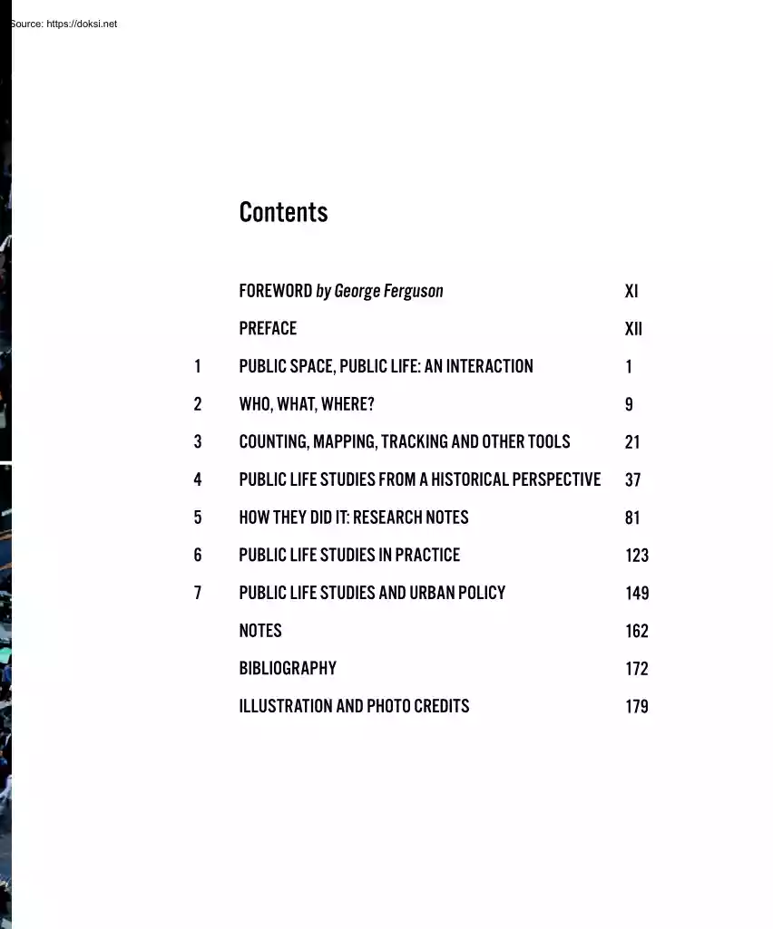
Contents FOREWORD by George Ferguson XI PREFACE XII 1 PUBLIC SPACE, PUBLIC LIFE: AN INTERACTION 1 2 WHO, WHAT, WHERE? 9 3 COUNTING, MAPPING, TRACKING AND OTHER TOOLS 21 4 PUBLIC LIFE STUDIES FROM A HISTORICAL PERSPECTIVE 37 5 HOW THEY DID IT: RESEARCH NOTES 81 6 PUBLIC LIFE STUDIES IN PRACTICE 123 7 PUBLIC LIFE STUDIES AND URBAN POLICY 149 NOTES 162 BIBLIOGRAPHY 172 ILLUSTRATION AND PHOTO CREDITS 179 IX X Foreword by George Ferguson Jan Gehl has devoted a lifetime to the field of public life studies, which has developed since the sixties when, as a young student of architecture, I first became aware of his work. Gehl’s vision is one of making cities fit for people He and his colleagues, including Birgitte Svarre, have written about it and advised cities, developers, NGOs and governments. This book goes behind the scenes and reveals the variety of tools in the public life studies toolbox. A proper understanding of its application is vital to all
those involved in city planning and others responsible for the quality of life in our cities. As more of us move to the city, the quality of urban life moves higher on both the local and global political agendas. Cities are the platform where urgent matters such as environmental and climate questions, a growing urban population, demographic changes, and social and health challenges must be addressed. Cities compete to attract citizens and investment. Should that competition not be focused on the quality of life, on the experience of living in, working in, and visiting cities rather than on those superficial aspects represented by the tallest building, the biggest spaces or the most spectacular monuments? This fascinating book’s examples from Melbourne, Copenhagen, New York and elsewhere illustrate how, by understanding people’s behaviour and systematically surveying and documenting public life, our emphasis can change. Major changes can take place by using public life studies as
one of the political tools. Think back five years; nobody would have dreamt of turning Times Square into a people place rather than a traffic space. Public life study was a key part of the process that enabled it to be realized so successfully. ‘Look and learn’ is the underlying motto of this book: get out in the city, see how it works, use your common sense, use all senses, and then ask whether this is the city we want in the 21st century? City life is complex, but with simple tools and systematic research it becomes more understandable. When we get a clearer image of the status of life in cities, or even just start to focus on life, not on individual buildings or technicalities, then we can also ask more qualified questions about what it is we want – and then public life studies can become a political tool for change. The study of public life represents a cross-disciplinary approach to planning and building cities, where the work is never finished, where you always take a
second look, learn, and adjust – always putting people first. It is the essence of good urbanism. George Ferguson CBE, PPRIBA Mayor of City of Bristol, United Kingdom XI Preface Public life studies are straightforward. The basic idea is for observers to walk around while taking a good look. Observation is the key, and the means are simple and cheap. Tweaking observations into a system provides interesting information about the interaction of public life and public space. This book is about how to study the interaction between public life and public space. This type of systematic study began in earnest in the 1960s, when several researchers and journalists on different continents criticized the urban planning of the time for having forgotten life in the city. Transport engineers concentrated on traffic; landscape architects dealt with parks and green areas; architects designed buildings; and urban planners looked at the big picture. Design and structure got serious attention,
but public life and the interaction between life and space was neglected. Was that because it wasn’t needed? Did people really just want housing and cities that worked like machines? Criticism that newly built residential areas lacked vitality did not come only from professionals. The public at large strongly criticized modern, newly built residential areas whose main features were light, air and convenience. XII The academic field encompassing public life studies, which is described in this book, tries to provide knowledge about human behavior in the built environment on an equal footing with knowledge about buildings and transport systems, for example. The original goal is the same goal today: to recapture public life as an important planning dimension Although the concept of public life may seem banal compared to complex transport systems, reinvigorating it is no simple task. This is true in cities where public life has been squeezed almost into nonexistence, as well as in
cities that have an abundance of pedestrian life, but a depressed economy that prevents establishing the basic conditions for a decent walking and biking environment. It takes political will and leadership to address the public life issue. Public life studies can serve as an important tool for improving urban spaces by qualifying the goal of having more people-friendly cities. Studies can be used as input in the decision-making process, as part of overall planning, or in designing individual projects such as streets, squares or parks. Life is unpredictable, complex and ephemeral, so how on Earth can anyone plan how life might play out in cities? Well, of course, it is not possible to pre-program the interaction between public life and space in detail, but targeted studies can provide a basic understanding of what works and what does not, and thus suggest qualified solutions. The book is anchored in Jan Gehl’s almost 50 years of work examining the interplay between public life and
public space. He honed his interest in the subject as a researcher and teacher at the School of Architecture, The Royal Danish Academy of Fine Arts in Copenhagen, and in practice at Gehl Architects, where he is a founding partner. Thus many of the examples in the book come from Jan Gehl’s work. The book’s second author, Birgitte Svarre, received her research education at the Center for Public Space Research at The Royal Danish Academy of Fine Arts, School of Architecture. The center was established in 2003 under Jan Gehl’s leadership. Birgitte Svarre has a master’s degree in modern culture and cultural communication and thus carries on the interdisciplinary tradition that is characteristic of the field of public life studies. Our goal with this book is twofold: we want to inspire people generally to take public life seriously in all planning and building phases, and we want to provide tools and inspiration from specific examples of how public life can be studied simply and
cheaply. Our hope is that the book will inspire readers to go into the city and study the interaction between city space and city life in order to acquire more knowledge and to qualify the work regarding living conditions in cities. The book focuses on tools and process, not results. In this context, these tools – or methods, if you prefer – should not be seen as anything other than different ways of studying the interaction between city life and city space. They are offered as an inspiration as well as a challenge to develop them further, always adjusted to local conditions. The first chapter gives a general introduction to public life study. Chapter 2 presents a number of basic questions in this field of studies. Chapter 3 provides an overview of tools used to study the interaction of public space and public life. Chapter 4 summarizes the social history and academic background for public life studies. Key people and ongoing themes tie the field together Chapter 5 contains several
reports from research frontlines with various views on public life studies. Early studies are emphasized, because the methods were developed in order to describe the considerations about their use and further development. Chapter 6 reviews examples from practice, the so-called public space-public life studies developed by Jan Gehl, and later Gehl Architects, and used systematically since the end of the 1960s in many different cities: large, medium, small, located north, south, east and west. Therefore, today there is a large body of material from which to draw conclusions. Chapter 7 recounts the history of the use of public life studies in Copenhagen as a political tool. In conclusion, public life studies are put into a historic, social and academic perspective – in relation to research as well as practice. Although the book is a collaborative effort between two authors, it would not have been possible without the rest of the team: Camilla Richter-Friis van Deurs, responsible for
layout and graphics; Annie Matan, Kristian Skaarup, Emmy Laura Perez Fjalland, Johan Stoustrup and Janne Bjørsted for their various types of motivated and qualified input and effort. Once again, it was a pleasure to work with Karen Steenhard on the English translation of the book. Our heartfelt thanks go to Gehl Architects for workspace, assistance and an inspiring environment – and a particular thanks to the many colleagues, partners and other friends of the firm who helped with photographs and as sparring partners. Special thanks to Lars Gemzøe, to Tom Nielsen for his constructive reading of draft texts and to Island Press, Heather Boyer in particular, as well as the Danish publisher Bogværket. We thank Realdania for their support of the project idea and the financial assistance to help make it happen. Jan Gehl and Birgitte Svarre Copenhagen, May 2013 XIII 3 COUNTING, MAPPING, TRACKING AND OTHER TOOLS This chapter describes various tools for systematizing and
registering direct observations of the interaction between public space and public life. A few cases of indirect observations are mentioned, such as using cameras or other technical devices to register or look for traces of human activity. Regardless of the tools selected, it is always necessary to consider the purpose and timing of the study. General questions of this type are dealt with briefly in this chapter, and the key registration tools described. Other tools exist, of course, but we present those that the authors of the books consider the most important, based on their own experiences. Purpose of Study and Tool Selection Purpose, budget, time and local conditions determine the tools selected for a study. Will the results be used as the basis for making a political decision, or are some quick before-and-after statistics needed to measure the effect of a project? Are you gathering specific background information as part of a design process, or is your study part of a more
general research project to gather basic information over time and across geographic lines? The choice of tools is dependent on whether the area studied is a delimited public space, a street, a quarter or an entire city. Even for a delimited area, it is necessary to consider the context of the study holistically, including the local physical, cultural and climate aspects. A single tool is rarely sufficient. It is usually necessary to combine various types of investigation. Choosing Days – Wind and Weather The purpose of the study and local conditions determine which points in time are relevant for registration. If the study area has a booming night life, the hours right up to and after midnight are important. If the area is residential, perhaps it is only relevant to register data until early evening. Registration at a playground can be wrapped up in the afternoon. There is a big difference between weekdays and weekends, and in general, patterns change on days leading up to
holidays. Since good weather provides the best conditions for outdoor public life, registrations are usually made on days with good weather for the time of year. Naturally, regional differences are dramatic, but for public life studies, the criterion is the kind of weather that provides the best conditions for outdoor life, especially staying. The weather is particularly sensitive for registering stays, because even if inclement weather clears up, people do not sit on wet benches, and if it feels like rain, most people are reluctant to find a seat. If the weather no longer lends itself to staying in public space in the course of a registration day, it can be necessary to postpone the rest of an investigation to another day with 22 better weather. It is usually not a problem to combine registrations from two half days into one useful full-day study Registration can be interrupted by factors other than weather. A large crowd of fans on their way to a game or a demonstration would
significantly change an ordinary pattern of movement. The results of registrations will always be a kind of modified truth because, hopefully, nothing is entirely predictable. Unpredictability is what makes cities places where we can spend hours looking at other people, and unpredictability is what makes it so difficult to quite capture the city’s wonderfully variable daily rhythm. The impulsiveness of cities heightens the need for the observer to personally experience and notice the factors that influence the urban life. Herein lies one of the principal differences between using man as registrar rather than automated tools and machines. Manual or Automated Registration Methods The observation tools described are primarily manual, which by and large can be replaced by automated registration methods. In the 1960s, 70s and 80s, most studies were conducted manually, but newer technological solutions can register numbers and movements remotely. Automated registration makes it possible
to process large amounts of data. It does not require the same manpower to conduct observations, but does require investments in equipment as well as in manpower to process the data collected. Therefore, the choice of manual or automated method is often dependent on the size of the study and the price of the equipment. Much of the technical equipment is either not very common or in an early stage of development, which makes it even more relevant to consider the advantages and disadvantages. However, it is likely that automated registration will play a more prominent role in public life studies in future. In addition, automated registration must often be supplemented by a careful evaluation of the data collected, which can end up being as time-consuming as direct observation. Simple Tools Almost for Free All the tools in the public life toolbox were developed for a pragmatic reason: to improve conditions for people in cities by making people visible and to provide information to
qualify the work of creating cities for people. It is also important for the tools to function in practice The tools can be adapted to fit a specific task, and are usually developed to meet the general professional, societal and technological development. Generally, the tools are simple and immediate, and the studies can be conducted on a very modest budget. Most studies only require a pen, a piece of paper, and perhaps a counter and stopwatch. This means that non-experts can conduct the studies without a large expenditure for tools. The same tools can be used for large or small studies. Key for all studies are observation and the use of good common sense. The tools are aids for collecting and systematizing information The choice of one tool over another is not as important as choosing relevant tools and adapting them to the purpose of the study In order to compare the results within a study or compare with later studies in the same or some other place, it is essential to make precise
and comparable registrations. It is also important to carefully note weather conditions and time of day, day of the week and month in order to conduct similar studies later. 23 Counting Counting is a widely used tool in public life studies. In principle, everything can be counted, which provides numbers for making comparisons before and after, between different geographic areas or over time. Mapping Activities, people, places for staying and much more can be plotted in, that is, drawn as symbols on a plan of an area being studied to mark the number and type of activities and where they take place. This is also called behavioral mapping. Tracing People’s movements inside or crossing a limited space can be drawn as lines of movement on a plan of the area being studied. Tracking In order to observe people’s movements over a large area or for a longer time, observers can discreetly follow people without their knowing it or follow someone who knows and agrees to be followed
and observed. This is also called shadowing. Looking for traces Human activity often leaves traces such as litter in the streets, dirt patches on grass etc., which gives the observer information about the city life These traces can be registered through counting, photograping or mapping. Photographing Photographing is an essential part of public life studies to document situations where urban life and form either interact or fail to interact after initiatives have been taken. Keeping a diary Keeping a diary can register details and nuances about the interaction between public life and space, noting observations that can later be categorized and/or quantified. Test walks Taking a walk while observing the surrounding life can be more or less systematic, but the aim is that the observer has a chance to notice problems and potentials for city life on a given route. 24 Counting Counting is basic to public life studies. In principle, everything can be counted: number of people,
gender division, how many people are talking to each other, how many are smiling, how many are walking alone or in groups, how many are active, how many are talking on their cell phones, how many shop windows have metal bars after closing, how many banks there are, and so on. What is often registered is how many people are moving (pedestrian flow) and how many are staying (stationary activities). Counting provides quantitative data that can be used to qualify projects and as arguments in making decisions. Numbers can be registered using a handheld counter or by simply making marks on a piece of paper when people walk past an imaginary line. If the goal is to count people staying, the observer typically walks around the space and does a headcount. Counting for ten minutes, once an hour, provides a rather precise picture of the daily rhythm. City life has shown to be quite rhythmic and uniform from one day to the next, rather like a lung that breathes. Yesterday is very much like
tomorrow.1 Naturally, it is crucial to conduct the count for exactly ten minutes, because this is a random sample that will later have to be repeated in order to calculate pedestrian traffic per hour. All of the individual hours will then be compiled in order to get an overview of the day. Therefore, even small inaccuracies can invalidate the results. If the site is thinly populated, counting must be continued for a longer interval in order to reduce uncertainly. If anything unexpected happens, it must be noted: for example, a demonstration involving lots of people, road work or anything else that might influence the number of people present. By conducting headcounts before and after initiatives in city space, planners can quickly and simply evaluate whether the initiative resulted in more life in the city, broader representation of age groups, etc. Counting is typically conducted over a longer period in order to compare different times of day, week or year. Headcounts in Chongqing,
China.2 Registering all the pedestrians who walk by. If there are many pedestrians, a counter is invaluable (right). 25 Mapping Mapping behavior is simply mapping what happens on a plan of the space or area being investigated. This technique is typically used to indicate stays, that is, where people are standing and sitting. The locations of where people stay are drawn at different times of day or over longer periods. The maps can also be combined layer on layer, which gradually provides a clearer picture of the general pattern of staying activities. In order to envision activities throughout the day, it is essential to register several samples in the form of momentary 'pictures' in the course of a day. This can be done by mapping stays on a plan of the area being investigated at selected points in time throughout the day. Thus mapping shows where the stays are made, and the observer can use a symbol (an X, a circle, a square) to represent the different types of
stationary activities – what is going on, in other words. One registration answers several questions, and the qualitative aspects about where and what supplement the quantitative nature of the counting. This method provides a picture of a moment in a given place. It is like an aerial photo that fast-freezes a situation If the entire space is visible to the observer, he or she can plot all the activities on the plan from one vantage point. If the space is large, the observer must walk through it, mapping stays and putting the many pieces together to get the total picture. When walking through a space, it is important for observers not to be distracted by what is going on behind them, but rather to focus on what is happening abreast. The point is to capture one single picture of the moment rather than several. 26 1. Original captions from "People in Cities", Arkitekten no. 20, 1968: 1. "Winter day Tuesday, 2.2768 () Plan B1, which indicates standing and seated people
in the area at 11.45 am, shows that all the seating in the sun is occupied, while none of the other benches in the area are being used. The largest concentration of people standing is near the hotdog stand on Amagertorv. The plan also shows that people standing to talk and standing to wait are either in the middle of the street or along the façades." 2. "Spring day Tuesday, 052168 (.) As in February, about 100 people on average are standing in front of shop windows, but all other forms of activity have increased. Most marked is the growth in the number of people standing and looking at what is going on. It is warmer now, and more is happening, therefore more to look at." 3. "Summer day Wednesday, 072468 (.) The number of pedestrians, about 30%, standing in front of shop windows is unchanged. This would appear to be a constant. () In general it can be observed that the center of gravity in the area has shifted from the commercial street Vimmelskaftet to the more
recreational square Amagertorv."3 2. 3. Tracing Registering movement can provide basic knowledge about movement patterns as well as concrete knowledge about movements in a specific site. The goal can be to gather information such as walking sequence, choice of direction, flow, which entrances are used most, which least, and so on. Tracing means drawing lines of movement on a plan. People’s movements are watched in a given space in full view of the observer. The observer draws the movements as lines on a plan of the area during a specific time period, such as 10 minutes or half an hour. Tracing is not exact, as it can be difficult to represent lines of movement if there are many people moving through a given space. It may be necessary to divide the space into smaller segments. Tracing movements on a plan provides a clear picture of dominant and subordinate lines of flow as well as areas that are less trafficked. GPS equipment can be used to register movements in a large
area such as an entire city center or over a long period. Registration, hand-drawn sketch: Movements on a plan made in the courtyard of the Emaljehaven housing complex in Copenhagen, by Gehl Architects in 2008. Every line represents one person’s movements in the space. Lines were drawn every 10 minutes on tracing paper, which was then layered to provide an overall picture of the movement patterns. 28 Rentemestervej Saturday the 13th of September from 12-3 p.m Walking patterns at noon, 1, 2, and 3 o’clock Tracking In addition to standing in one place to register movement, observers can also follow selected people in order to register their movements, which is called shadowing or tracking. This method is useful for measuring walking speed, or where, when and to what extent certain activities take place along a route. Activities could be actual stays or more subtle acts such as turning the head, stopping, making unexpected detours, etc. The method could also be used, for
example, to map the route to and from a school in order to make it safer. Speed observations can be made with the naked eye and a stop watch by following the person whose speed you want to measure. Observers must keep a reasonable distance so that the person being observed does not get the feeling that he or she is being followed. Another option is to observe speed over a measured distance from a window or other site above street level. If the goal is to get a total picture of an individual’s movements over a period of time, a pedometer is useful. GPS registration is also useful for measuring speeds on given routes A variation of shadowing is to follow someone who knows and agrees to being followed and observed. GPS registration can be used for remote shadowing of selected people. Photo from the tracking registrations on Strøget, Copenhagen’s main pedestrian street, in December 2011.4 The observer follows randomly selected pedestrians (every third), using a stop-watch to time
how long it takes the person to walk 100 meters. When the person being shadowed passes the imaginary 100-meter line, the watch is stopped. If the pedestrian does not follow the premeasured route, tracking that particular person is abandoned Looking for Traces Human activity can also be observed indirectly by looking for traces. Indirect observation requires observers to sharpen their senses just like detectives on the trail of human activity or the lack hereof. A core tenet of public life studies is to test the actual conditions in the city by observing and experiencing them firsthand and then considering which elements interact and which do not. What is relevant for testing differs from place to place. Looking for traces could mean recording footprints in the snow, which attest to the lines people follow when they cross a square, for example. Traces might also be found in trampled paths over grass or gravel, or as evidence of children’s play in the form of temporarily abandoned
toys. Traces could be tables, chairs and potted plans left outside in the evening, which indicate a quarter where residents confidently move their living room into public space and leave it there. Traces could show just the opposite: hermetically sealed shutters and bare porches can indicate a quarter with no signs of life. Traces can be things left behind or things used in ways not originally intended, such as traces of skateboarding on park benches. Left: Tracks left in the snow at Town Hall Square, Copenhagen, Denmark Right: Like everyone else, architecture students take the most direct route: The Royal Danish Academy of Fine Arts, School of Architecture, Copenhagen, Denmark. Photographing Photographs are frequently used in the field of public life studies to illustrate situations. Photographs and film can describe situations showing the interaction or lack thereof between urban form and life. They can also be used to document the character of a site before and after an
initiative. While the human eye can observe and register, photographs and film are good aids for communication. Photographing and filming can also be a good tool for fast-freezing situations for later documentation and analysis By later studying photographs or film, it is possible to discover new connections or to go into detail with otherwise complex city situations that are difficult to fully comprehend with the naked eye. Photographs often illustrate and enliven data. In the field of public life studies, photographs of public life scenes are not subjected to the usual aesthetic principles so dear to the hearts of architects generally. Here the emphasis is not on design but rather on situations that occur in the interaction between public life and public space. Photographs can be used generally as well as in specific projects to document life and conditions for life in public space. And even though it is a bit of a cliché, one picture can be worth 1000 words, particularly because
the viewer can identify with the people in the pictures, which are often snapped at eye level. Variations include time-lapse photography or video sequences to show situations over time, with or without the presence of the observer. The angle and size of the lens is relevant if either film or photograph is to correspond to the human field of vision. Good observation post, good company and good study objects: Piazza Navona, Rome, Italy. Keeping a Diary All of the tools described above provide only random samples of the interaction of public life and public space. These samples of what is taking place can rarely provide all the details. However, details can be vital additions to our understanding of how life in public space develops as sequences and processes. One way to add detail is to keep a diary. Noting details and nuances can increase knowledge about human behavior in public space for individual projects as well as to add to our more basic understanding in order to develop the
field. The method is often used as a qualitative supplement to more quantitative material in order to explain and elucidate hard data. Keeping a diary is a method of noting observations in real time and systematically, with more detail than in quantitative ‘sample’ studies. The observer can note everything of relevance. Explanations can be added to general categories such as standing or sitting, or brief narratives can aid our understanding of where, why and how life plays out in 32 an event that is not exclusively purpose-driven. Examples could include someone mowing a front-yard lawn at several times during the day, or an older woman who empties her mailbox several times on a Sunday.6 Keeping a diary can also be used as a supplementary activity, with the observer adding explanations and descriptions to facts and figures. Keeping a diary can register events that cannot easily be documented using more traditional methods. This example shows notes from a study of residential
streets in Melbourne, Australia. Shown at right is a page from a diary for the Melbourne study.5 The two-page spread below depicts Y Street, Prahran, Melbourne, Australia. The physical framework is described on the left-hand page – the dimensions and form of the street. The right-hand page describes the activities taking place on the street during one Sunday. 33 Test Walks To make test walks, the observer walks selected important routes, noting waiting times, possible hindrances and/or diversions on the way. There can be great differences in walking a distance measured in sight lines and a theoretical idea about how long it takes to walk from point A to point B, and the time it actually takes to walk that distance. The actual walk can be slowed by having to wait at stoplights or by other hindrances that not only slow the pedestrian but make the walk frustrating or even unpleasant. Test walks are a good tool for discovering this type of information. 17 % Waiting time 30%
Waiting time 38% Waiting time 52% 33% Waiting time Waiting time Test walks were carried out as an important element in the public life studies conducted in Perth and Sydney, Australia (1994 and 2007, respectively). In both cities, pedestrians spent a significant amount of their time waiting at the many traffic lights prioritizing car traffic.7 The test walks proved to be a strong political tool in efforts to provide better conditions for pedestrian traffic. 19% Waiting time 1: 20,000 n 600 m 34 Test walks in Sydney showed that up to 52% of total walking time was spent waiting at traffic lights.8 35
 Írásunkban a műelemzések készítésének módszertanát járjuk körül. Foglalkozunk az elemzés főbb fajtáival, szempontjaival és tanácsokat adunk az elemzés legfontosabb tartalmi elemeivel kapcsolatban is. Módszertani útmutatónk főként tanulók számára készült!