Please log in to read this in our online viewer!
Please log in to read this in our online viewer!
No comments yet. You can be the first!
What did others read after this?
Content extract
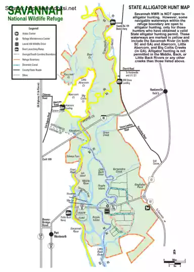
,. J Source: http://www.doksinet SAVANNAH National Wildlife Refuge . l -•-•~ / Legend {:, O i=J E!I VisltorCenter l ;) (° ~ • r.ou Rd 110 Bec~Ferry j i J :::il i 'p ,~ .f:J"o/ Georgia/SouthCarolinaBoundary - ) BoatlaunchingRamp ci-, , j,y ,~ 8 ~:.' RefugeBoundary STATE ALLIGATOR HUNT MAP ~ . (" ,. RefugeMaintenanceCenter LaurelHillW'ildlifeDrive . ;, """'· / Savannah NWR 1s NOT open to alhgator huntmg However, some nav1gable waterways w1thm the refuge boundary are open to alhgator huntmg, only for those S~~t~t=~~g~~ir i~vn~1~~t~~r~1: ~~~~e waterways are marked m yellow and mclude the Savannah R1ver (m both SC and GA) and Abercorn , Little Abercorn, and Big Collis Creeks (in GA). Alligator hunting is not 1 Ptft~:~~d~ ~~=e~dir : •n~~~~•e~r creeks than those listed above. DiversionCanal ( County/StateP.oads Dikes j ;•' i SolomooTract , ,.~ 'l' j Frpnt i
Ríver,,,• Is/a • Island ) / / Miefd/e Rivor Ste.9 • -tr%. Houslo'Ml 1· -2. ~1rt 1 ~ '""' r--. N
Ríver,,,• Is/a • Island ) / / Miefd/e Rivor Ste.9 • -tr%. Houslo'Ml 1· -2. ~1rt 1 ~ '""' r--. N
