Comments
No comments yet. You can be the first!
Most popular documents in this category


Content extract
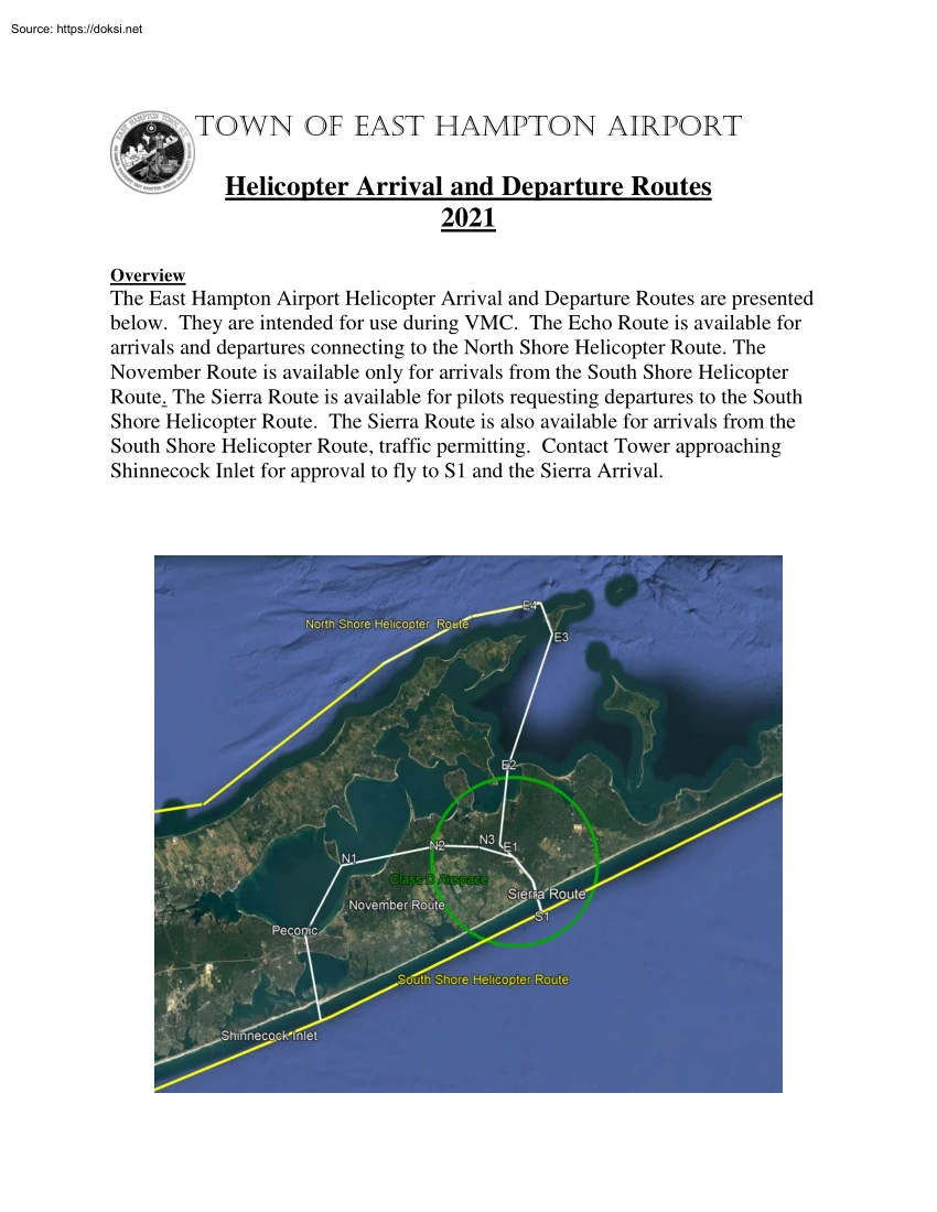
Town of East Hampton Airport Helicopter Arrival and Departure Routes 2021 Overview The East Hampton Airport Helicopter Arrival and Departure Routes are presented below. They are intended for use during VMC The Echo Route is available for arrivals and departures connecting to the North Shore Helicopter Route. The November Route is available only for arrivals from the South Shore Helicopter Route. The Sierra Route is available for pilots requesting departures to the South Shore Helicopter Route. The Sierra Route is also available for arrivals from the South Shore Helicopter Route, traffic permitting. Contact Tower approaching Shinnecock Inlet for approval to fly to S1 and the Sierra Arrival. Echo Departures: Depart heading northwest to E1 at BROC. Turn right to E2 Cross E2 at 2500 feet Proceed to E3. Cross E3 at 2500 feet Join the North Shore Helicopter Route at E4 The Echo Route waypoints MUST be flown precisely for noise abatement. Arrivals: Proceed eastbound on the North Shore
Helicopter Route to E4. Cross E4 at 3500 feet Proceed to E3, E2 and E1 as depicted. Remain at 3500 ft as close in as possible for noise abatement. The Echo Route waypoints MUST be flown precisely for noise abatement E1 [40*58’26” N / 07216’06” W] E2 [41*02’32” N / 07215’28” W] E3 [41*09’42” N / 07212’03” W] E4 [41*11’26” N / 07212’52” W] November Arrivals: Transition off the South Shore Helicopter Route at Shinnecock Inlet and proceed to PECONIC and N1, the south tip of Robins Island. Cross N1 at 3500 feet Then as depicted to N2 and N3 Maintain 3500 ft. as close in as possible for noise abatement Shinnecock Inlet [40*49’35” N/ 7228’22” W] Peconic [40*53’51” N / 7229’30” W] N1 [40*57’19” N / 07227’04” W] N2 [40*58’23” N / 07220’25” W] N3 [40*58’16” N / 07217’32” W] Sierra Departures: When traffic permits, perform a climbing turn north of the airport to gain altitude before proceeding south to S1. Proceed
over Georgica Pond to S1 at 2500 feet Proceed on course Arrivals: Contact Tower approaching Shinnecock Inlet to request a Sierra Arrival. If Tower does not respond or cannot approve the Sierra Arrival, fly the November Arrival. If Tower approves the Sierra Arrival, proceed to cross S1 at 2000 feet. Proceed to landing per ATC instructions S1: [40*54’56”N / 7213’17” W] PLEASE NOTE: Echo Arrivals contact ATCT at E3 or “Plum Gut”. November Arrivals contact ATCT at N1 or “Robins Island”. Sierra Arrivals contact ATCT approaching Shinnecock Inlet for approval to proceed. Pathways depicted on the map are for illustration only and may not conform precisely to coordinates. Published coordinates are controlling If weather conditions prevent published altitudes from being flown, remain in VMC and adjust as necessary. ATCT will advise pilots of traffic conflicts on each of the helicopter routes and will retain the option of issuing arrival and departure instructions as traffic
permits. These procedures are not intended to preempt the responsibilities of the pilot-in-command from safe aircraft operations. Recommended procedures are not intended to conflict with instructions from ATC or any applicable Federal Aviation Regulations. East Hampton Airport Curfew: 2200L – 0700L. No ramp services available during those hours. Special VFR clearances will not be provided during Class D operations. Rev. 13 4/27/2021