Comments
No comments yet. You can be the first!
Most popular documents in this category


Content extract
AARMS Vol. 14, No 2 (2015) 219–236 Detecting Military Historical Objects by LiDAR Data JUHÁSZ Attila,1 NEUBERGER Hajnalka2 Light Detection and Ranging (LiDAR) technology has become one of the major remote sensing methods in the last few years. There are several areas, where the scanned 3D point-clouds can be used very efficiently. In our study we review the potential applications of LiDAR data in military historical reconstruction. Previously we defined the major steps of the entire reconstruction process and the – mostly archive – useful data sources. Obviously the base of this kind of investigations must be archive data, but it is an interesting challenge to integrate a cutting edge method into such tasks. LiDAR technology can be very useful, especially in vegetation covered areas, where the conventional remote sensing technologies are mostly inefficient. We shall summarize how laser scanned data can support the different parts of reconstruction work and define the
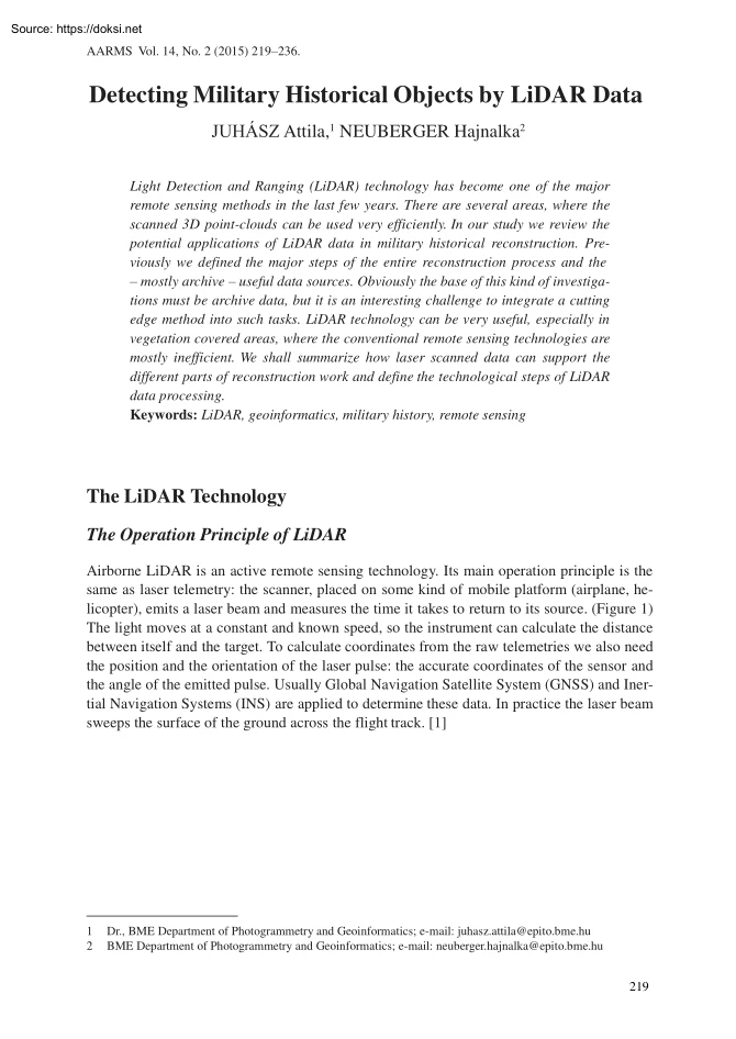
technological steps of LiDAR data processing. Keywords: LiDAR, geoinformatics, military history, remote sensing The LiDAR Technology The Operation Principle of LiDAR Airborne LiDAR is an active remote sensing technology. Its main operation principle is the same as laser telemetry: the scanner, placed on some kind of mobile platform (airplane, helicopter), emits a laser beam and measures the time it takes to return to its source. (Figure 1) The light moves at a constant and known speed, so the instrument can calculate the distance between itself and the target. To calculate coordinates from the raw telemetries we also need the position and the orientation of the laser pulse: the accurate coordinates of the sensor and the angle of the emitted pulse. Usually Global Navigation Satellite System (GNSS) and Inertial Navigation Systems (INS) are applied to determine these data In practice the laser beam sweeps the surface of the ground across the flight track. [1] 1 2 Dr., BME Department of
Photogrammetry and Geoinformatics; e-mail: juhaszattila@epitobmehu BME Department of Photogrammetry and Geoinformatics; e-mail: neuberger.hajnalka@epitobmehu 219 JUHÁSZ Attila, NEUBERGER Hajnalka: Detecting Military Historical Objects by LiDAR Data Figure 1. The operation principle of LiDAR [2] To understand the technology we need to review some basic characteristics of the laser beam: [3] • monochromatic, • coherent, • very little divergence, • polarized, • concentrated energy. According to the energy emitted and the distance the laser beam disperses; it reaches the ground surface as an ellipse (in practice with about 25–40 cm major axis) called the footprint, and then reflects from this point. Thanks to this characteristic, a single laser beam can reflect from numerous and various levels (ground level, understory level, crown level), this is called multiple returns. The early systems could record only one return, and then the first and last pulse detection was
achieved. Nowadays it is possible to record more discrete returns (even 4–6) and the full waveform of the beam can also be detected by some systems. (Figure 2) 220 AARMS (14) 2 (2015) JUHÁSZ Attila, NEUBERGER Hajnalka: Detecting Military Historical Objects by LiDAR Data Figure 2. The principle of full waveform detection [2] Accuracy is another important characteristic that has to be discussed. Basically, the overall accuracy depends on the accuracy of the components (laser rangefinder, GNSS, INS) and the calibration of the sensor and the navigation system. Omitting the details, we can declare that in practice the accuracy of this measurement is about 15 cm vertically and about 25 cm horizontally. [4] Airborne LiDAR technology is conventionally applied in civilian areas, like engineering [5] but nowadays it is also used in archaeological projects, [6] [7] even in Hungary. [8] Moreover it plays a more significant role in military missions, [9] education and training support.
[10] For example in target positioning, detection of camouflaged and hidden objects, tactical map creation and battlefield simulation. AARMS (14) 2 (2015) 221 JUHÁSZ Attila, NEUBERGER Hajnalka: Detecting Military Historical Objects by LiDAR Data The LiDAR data Airborne LiDAR data are usually stored in .las files [11] Instead of a detailed review of this file format we present just a few important and useful pieces of information about the .las file for the users The collected point cloud can be managed as a huge matrix and can be handled in mathematical software. Figure 3 represents sample data from Siófok loaded into MATLAB (matrix laboratory) software. The rows consist of coherent values of the single measurements and the columns represent the followings: • X (m) UTM (horizontal) coordinate; • Y (m) UTM (vertical) coordinate; • Z (m) height above ellipsoid WGS84; • intensity of discrete returns; • return number of reflection; • total number of returns in a single
beam; • 7–262. recorded values of the full-waveform Figure 3. LiDAR data in MATLAB [2] 20th Century Hungarian Military Objects In this chapter we review the potential of applying LiDAR data in the reconstruction of the Hungarian military historical objects and events in the 20th century. First, we briefly summarize the potential military historical events, locations and the typical military defense objects of the century. There are no existing significant military objects (fortress or fortress parts) connected to World War I, in Hungary. There are some infrastructure and service facilities throughout the country (Budapest, Komárom, Mosonmagyaróvár). These facilities are mostly well known and mapped. The occurrent LiDAR scanning of these buildings can be used as reference data to locate and identify such objects in the investigation of new areas. Additionally, LiDAR measurements can be controlled and validated by field measurements. 222 AARMS (14) 2 (2015) JUHÁSZ Attila,
NEUBERGER Hajnalka: Detecting Military Historical Objects by LiDAR Data As opposed to World War I, a lot of important events of World War II happened in the country. The objects that formed defensive fortifications (lines) built in this period are the potential targets of our research. These defensive lines spanned across the whole country from the north eastern region in a south western direction (Árpád-, Karola-, Attila-, Margit-line). The most important parts of these defense systems were the anti-tank trenches, the infantry trench systems and the various placements (flack, artillery). Based on of the size of these defense objects we can suppose that today’s measurements also capture the signs of the larger parts of the defensive lines. The proper sizes of the anti-tank trenches are 8–10 meters width and 4–6 meters depth, so there is a great chance to locate the remains despite several decades of intensive agricultural activities in the concerned areas. Unfortunately, most
infantry trenches have already disappeared from these agricultural areas, but there were several cases when the trenches were built next to forests or parallel with roads and dirt roads; some of these areas are still almost untouched. In these cases the trenches are usually covered by dense vegetation (grass, bushes, trees), so it seems reasonable to apply LiDAR survey and the most common process, the digital elevation model generation through vegetation removal. The remains of the trenches have a 1–0.1 meter depth, so it can be declared that the trench point must be well separable from other ground points in the point cloud. Confirming this, Figure 4 represents a foreign example of detected fire trenches on digital terrain model derived from LiDAR data. Figure 4. Fire trenches located with LiDAR data (black arrow) [12] Beside the World War II defensive lines, the South Defensive System (SDS) has to be mentioned, which was built in the early 1950’s. It was located close to the
former Yugoslavian border and was constructed in almost the same way as the earlier defensive lines, mentioned above The SDS consisted of field- and permanent-fortification parts too AARMS (14) 2 (2015) 223 JUHÁSZ Attila, NEUBERGER Hajnalka: Detecting Military Historical Objects by LiDAR Data In addition, we have to note that there have been only a few airborne LiDAR measurements carried out in Hungary until now. Unfortunately, none of these measurements were accomplished to reconstruct military defensive objects from the 20th century. However, there are some point clouds created by museums and national parks which include areas where potential defensive objects can be found. In these cases there is a possibility to locate these trenches or placements and to validate the known information based on laser scanned data. Potential Applications of LiDAR Data In this chapter we briefly review the point cloud processing, interpretation and visualization possibilities, which can
effectively support military historical object reconstruction. As mentioned previously, the earlier types of the LiDAR sensors could detect just one reflected signal. However, the main analysis and interpretation processes can be carried out on this kind of (containing only first pulse reflections) point cloud too. The first and probably the most important process is the classification of the point cloud. The primary goal of this step is to select ground points, i.e deriving the digital terrain model (DTM). The definition of the accurate DTM is essential in case of archaeological and military historical studies. The identification of the relatively small offsets is the key task during the micro-relief analysis, thus as a dense point cloud should be used when possible. There are various known processes to select the ground points. The most frequently used weighting algorithms based on the relative vertical offsets and the selection depending on the slope or curvature. We have to mention
that in most cases the software works in “black box” mode, so the users only have options to modify a few parameters or define typical land covers to achieve the best result. Numerous interpolation methods can be applied in creating the elevation model, resulting in barely different models. However, we can declare that the most important issue is the quality of the selected interpolation method, because it has the greatest influence on the result The most frequently applied interpolation methods are as follows: • Nearest Neighbour, • Natural Neighbour, • Linear interpolation, like TIN, • Inverse Distance Weighting, • Spline based solutions, • Radial Basis Function, • Kriging. Just like the interpolation methods, the various edge detection algorithms have a highlighted role in the military objects reconstruction. Applying these algorithms enables the enhancement, the accuracy and reliability of object detection, measuring the typical sizes and supporting the
identification. Here are some typical edge detection methods: • Roberts filter (calculate the direction and the value of the gradients, convolution filter, highlight edges in diagonal direction). • Sobel filter (calculate the direction and the value of the gradients, convolution filter, all direction, post-processing needed: thresholding). • Laplace filter (approximate the 2nd derivate value [0 at the edges], all direction, detecting blurred edges). 224 AARMS (14) 2 (2015) JUHÁSZ Attila, NEUBERGER Hajnalka: Detecting Military Historical Objects by LiDAR Data Obviously there are several other edge detectors. Usually it is recommended to apply pre- or post-processing along with these algorithms. For example, a smoothing filter can be useful before the edge detection, but we have to apply it carefully because it can delete the important small vertical differences from the data, which are necessary in most reconstruction cases. On the other hand the post-processing of the
filtered data (eg thresholding, edge thinning) can significantly improve the interpretation. Besides the filters and edge detectors, there are simple visualization and analysis methods that are also able to simplify our task. Geographic information system (GIS) and computer-aided design (CAD) software has the ability to create cross and longitudinal sections, an extrusion of the height values or vary the illumination direction. These techniques can facilitate detection, identification, measurement and representation of military objects. Applying the appropriate parameters the visualization of the point cloud can be more plastic and the important height differences can be highlighted. Figure 5 shows a point cloud which contains of World War I trenches near Kemmelberg (Belgium). There are different edge detectors and illumination directions used to improve the interpretation of the objects (see arrows). [13] Figure 5. Detecting trenches near Kemmelberg (Belgium) Applying Sobel (A) and
Laplace (B) filters and Northern (C) and Southern (D) illumination direction. [13] AARMS (14) 2 (2015) 225 JUHÁSZ Attila, NEUBERGER Hajnalka: Detecting Military Historical Objects by LiDAR Data Besides detecting the reflected laser beam pulses, the sensors record intensity values. This value depends on the color, material, texture and surface of the object from which the pulse backscattered. [14] Usually, these intensity data do not improve the military historical reconstruction process, because it does not carry extra information on the objects. Generally the investigated objects are made from concrete or soil, covered by vegetation. As mentioned earlier, current LiDAR sensors are able to record the full waveform of the reflected pulse, in parallel with the discrete returns. In this case two measurements (the discrete and the full waveform) are derived independently from two different digitizers, which use different scales. [15] Processing full waveform measurements are often
referred to as a potential procedure to gather more information about land cover and terrain objects, compared to the discrete detection methods. The research of the full waveform data is one of the hot topics of the LiDAR community; there are remarkable results in forested and in urban areas, but considering our aims, where the most reliable digital elevation model (DEM) is needed, these results are not so relevant. The selection, classification and the representation of the LiDAR data is achieved by specific tools, but the latest versions of GIS software also contain many useful functions. In addition, there are other useful features in GIS software to improve the reconstruction: [16] • manage various information from different data sources in a uniform reference system; • generate DEM; • interpolation methods; • database connection; • queries, spatial analysis; • 2D and 3D visualization, animation. So it seems to make sense to manage our LiDAR data in GIS environment
that opens the way of integrating image and map data, increasing the effectiveness of environmental-, military object- and military event reconstructions. The GIS database enables the management a number of attribute information and attached documentation. In conclusion, the LiDAR measurements and methodology are really useful in archaeology and military historical reconstruction, in object detection, identification or locating potential research territories. To achieve this, we need to set appropriately (if possible) the parameters and the time of data acquisition and carefully select the interpretation and representation methods. The detailed reasons for LiDAR data application are as follows: • Object detection (according to vegetation cover): - open area: ▪ investigate micro relief, ▪ investigate intensity values. - vegetation covered area: ▪ select foliage free period (if it is possible), ▪ remove the vegetation, create DEM, ▪ investigate micro relief. •
Identification (to achieve accurate object sizes): - the densest point cloud, - the most effective interpolation, - the most effective edge detector. • Representation (the most expediential and esthetic visualization): - illumination direction, - height data extrusion. 226 AARMS (14) 2 (2015) JUHÁSZ Attila, NEUBERGER Hajnalka: Detecting Military Historical Objects by LiDAR Data LiDAR Supported Reconstruction of a South Defensive System (SDS) Fortification Creating Uniform Base Map In this chapter, we investigate a typical part of the SDS near Sátorhely and Majs settlements. Firstly, we carried out a traditional military historical reconstruction based on conventional data sources (images, maps), then applied LiDAR data where it was available (the LiDAR file contained only discrete reflections). During the reconstruction process we used GIS software The base data were georeferred in Quantum GIS (QGIS); all the available maps, aerial images and satellite images were transformed
into the Hungarian EOV (Egységes Országos Vetület – Unified National Projection) coordinate system. During the transformation we had to consider that the aerial and satellite images were not orthorectificated, so both are distorted. There were a few meters inaccuracy, but according to the reconstruction’s demands, it was appropriate. The Reconstruction Process The first part of a complete military historical reconstruction is the environmental investigation of the period area. [17] The environment always has a great influence on the type, position and size of the military defensive system. The environmental reconstruction has two main steps. The past conditions can be derived from the recent state of the environment, from maps. (Figure 6) We applied ArcGIS software in this process, which has several cartographic functions, particularly in creating legends, so it is suitable for high quality mapping. The map objects were topologically corrected in GIS. Figure 6. Environmental
reconstruction based on aerial images and maps [18] AARMS (14) 2 (2015) 227 JUHÁSZ Attila, NEUBERGER Hajnalka: Detecting Military Historical Objects by LiDAR Data A major part of environmental reconstruction is processing height data. Both topographic maps (contour lines) and LiDAR measurements can be the sources of elevation data. GIS also enables 3D modeling. Unfortunately in our study the scanned points did not access from the whole investigated area (Figure 7), so we also made a 3D model from the digitized contour lines. (Figure 8) The defending capability of the defensive fortifications is mainly based on its location, depth and defense activity. As it is clearly visible in the investigated part of the SDS, the system was built to effectively stop and repulse the enemy with artillery, tanks and other engineering equipment, together with utilization of the terrain’s characteristics. The bases of defense were the battalion defensive areas (e.g Majs and Nagynyárád) and
the subordinate company positions (e.g Sátorhely) with connected fire control and engineering equipment systems. The battalion defensive areas were about 2 km in width and 15–2 km in depth The company standing-grounds were 800-1,000 meters in width and 400–600 meters in depth [19]. Figure 7. Digital surface model (DSM) from the LiDAR data [18] Figure 8. DEM from contour lines [18] 228 AARMS (14) 2 (2015) JUHÁSZ Attila, NEUBERGER Hajnalka: Detecting Military Historical Objects by LiDAR Data In the following, we review the typical defensive objects and their major characteristics, which can be detected and identified. Fire trench: a 0.6–1 meter wide and 1–15 meter deep infantry dugout, it enables safe and covered movement, and shooting at the enemy. Based on their typical shape and tracing, these trenches are relatively easy to identify. The reasons for the shape of fire trenches are the prevention of the enemy side fire and the reduction of an explosion’s
destructive impact. Anti-tank trench: an 8–10 meter wide, 4–6 meter deep trench, it is usually these that are tens or even hundreds of kilometers long. Also they have a typical shape with linear parts and relatively hard breakpoints. Various placements, bunkers: built in open or covered form alone or integrated in a defensive system. Because of their small (typically few meters in diameter) size, we can manage these objects as points in our investigations. In our case, we had the chance to identify anti-tank trenches, because of the area’s current land use (agricultural production). The point objects were digitized on the basis of the 1957 maps and the attributes came from the connected (paper) tables. There was a significant offset between the map based digitized point locations and the image based object locations, so we modified them based on the aerial images. As Figure 9 shows, the errors (see arrows) were not regular (offset between the numbered points coming from the map
and the little light patches on the image), so it was probably not the image to map transformation that caused them. The next step was trench digitizing based only on the image data (Figure 10) and in some cases on the LiDAR data. (Figure 11) Figure 12 shows the part of the military object reconstruction with a special legend. Figure 9. The offsets between the points coming from the map and the aerial image [18] AARMS (14) 2 (2015) 229 JUHÁSZ Attila, NEUBERGER Hajnalka: Detecting Military Historical Objects by LiDAR Data Figure 10. Detecting and digitizing fire- and anti-tank trenches from an aerial image [18] Figure 11. Anti-tank trench detected by kriging (above) and by Laplace filtering (bottom) [18] 230 AARMS (14) 2 (2015) JUHÁSZ Attila, NEUBERGER Hajnalka: Detecting Military Historical Objects by LiDAR Data Figure 12. Part of the military object reconstruction [18] Since there were not any military events in this area in the 1950’s, we studied the potential
assault directions as an event reconstruction. In fact, we investigated the possible directions for heavy vehicles and for the infantry according to the accessibility and the environment. In addition, we carried out some spatial GIS analysis of the area, in the following sections we provide examples for both investigations. The Investigation of Accessibility (Heavy Vehicle) The forested areas, the wetlands, the wider streams and the steeper slopes (>20–25°) cannot be passed by heavy vehicles and tanks. Therefore, we derived the slope map from the terrain model and represented the planimetric data on it. As a result it seems that there are steep slopes at the western and south-western side of the area and wetlands and forests are located on the eastern side. As potential assault directions we defined the following two tracks: (Figure 13) • 1st track: Tanks can pass through open terrain from south to north as far as the defensive trenches. However, the fortifications could stop
them • 2nd track: Moving on the side-roads, the tanks can go around the defensive line and reach Sátorhely. To avoid this case, the defense forces should destroy the bridges and create road obstacles. AARMS (14) 2 (2015) 231 JUHÁSZ Attila, NEUBERGER Hajnalka: Detecting Military Historical Objects by LiDAR Data Figure 13. The slope map with the potential assault directions (heavy vehicle) [18] The Viewshed Map It is important to build an appropriate observing network to keep the fortification elements under control and to direct the fire. At least the roads connecting the subunits must be observed Usually, according to the terrain and environment, these observation points were located on the side of ridges in well camouflaged locations Figure 14 represents the controlled territory from the Majs battalion observing point (marked by black triangle next to Majs), we assumed a 130 meters height. According to the prior expectation, the roads and almost the whole defensive system
are under control. To derive a better viewshed map we have to consider the followings: • the accurate position of the real observing point; • DSM usage instead of DEM; • refining analysis parameters. 232 AARMS (14) 2 (2015) JUHÁSZ Attila, NEUBERGER Hajnalka: Detecting Military Historical Objects by LiDAR Data Figure 14. The viewshed map derived from Majs observing point (black triangle next to Majs). [18] Finally, we review the typical LiDAR data processing steps in practice, supporting military historical reconstruction: • generating manageable data (clipping, resampling); • ground point selection; • classification; • DSM and DEM generation (Figure 16); • visualization; • GIS analysis (spatial, attribute-based); • archaeological and military historical reconstruction. Conclusions In this portion we shall summarize our experiences of applying LiDAR data in military historical reconstructions. The elementary advantages coming from the technology itself: •
direct 3D solution; • homogeneous point distribution; • high accuracy; • high resolution; • undistorted measurement; • directly enabled micro relief; • fast data processing. Through the military object reconstruction the anti-tank trenches can be detected almost in every cases and in case of beneficial circumstances (undisturbed area), the fire trenches and the placements can also be recognized. Further information can be derived by the simple coloring of the point cloud or creating cross sections or clippings. In our case, the estimated AARMS (14) 2 (2015) 233 JUHÁSZ Attila, NEUBERGER Hajnalka: Detecting Military Historical Objects by LiDAR Data depth of the detected anti-tank trench is 30 cm, as seen on the Figure 15. The potential applications of LiDAR data in object reconstruction are: • potential research territory detection / selection, even in forested areas; • direct 3D object measurements; • further information from the recorded intensity values; •
archiving objects and finds by scanning. Figure 15. 3D view of an anti-tank trench part to measure the depth [18] Figure 16. DSM (left) and DEM (right) of the investigated area [18] 234 AARMS (14) 2 (2015) JUHÁSZ Attila, NEUBERGER Hajnalka: Detecting Military Historical Objects by LiDAR Data References [1] BARSI Á., DETREKŐI Á, LOVAS T, TÓVÁRI D: Adatgyűjtés légi lézerletapogatással Geodézia és Kartográfia, 7 (2003). wwwfomihu/honlap/magyar/szaklap/2003/07/2pdf (downloaded: 06 03 2015) [2] TAMÁS J., FLÓRIÁN T: Geoinformatics Debrecen: Debreceni Egyetem, 2008 www.tankonyvtarhu/en/tartalom/tamop425/0032 terinformatika/ch05html (downloaded: 06 03 2015) [3] BOR Z.: A mindentudó fénysugár: a lézer In Mindentudás egyeteme 2003 II szemeszter http://mindentudas.hu/el%C5%91ad%C3%A1sok/tudom%C3%A1nyter%C3%BCletek/ term%C3%A9szettudom%C3%A1ny/103-fizikai-tudom%C3%A1nyok/6008-a-mindentudofenysugar-a-lezer.html (downloaded: 06 03 2015) [4] VERŐNÉ W. M: A lézer
alapú távérzékelés Sopron: Nyugat-magyarországi Egyetem, 2010. wwwtankonyvtarhu/hu/tartalom/tamop425/0027 FOI3/ch01html (downloaded: 06 03 2015) [5] LiDAR: The uses of LiDAR, LiDAR-UK. wwwlidar-ukcom/usage-of-lidar/ (downloaded: 06.032015) [6] CROW, P.: Savernake forest LiDAR Swindon: English Heritage, 2006 https://www.english-heritageorguk/professional/research/landscapes-and-areas/nationalmapping-programme/savernake-forest-nmp/savernake-forest-lidar/ (downloaded: 06 03 2015) [7] LAWRIE, B.: Beyon Angkor: How lasers revealed a lost city BBC News, 23 09 2014 www.bbccom/news/magazine-29245289 (downloaded: 06 03 2015) [8] GÁTI Cs.: A Pécs melletti Jakab-hegy őskori földvár LiDAR adatainak régészeti célú kiértékelése és térinformatikai integrálása. sl, 2014 [9] BuckEye. Alexandria: Army Geospatial Center wwwagcarmymil/Media/FactSheets/ FactSheetArticleView/tabid/11913/Article/480897/buckeye.aspx (downloaded: 06 03 2015) [10] AIR FORCE RESERVE COMMAND: Special
Mission, Special Team: IMAs step up to serve on critical 3-D imaging project. Citizen Airman, 11 15 2012 wwwcitamnafrcafmil/ features/story.asp?id=123326431 (downloaded: 06 03 2015) [11] ASPRS: LAS Specification Version 1.3 – R11 2010 Bethesda: The American Society for Photogrammetry & Remote Sensing, 2010. wwwasprsorg/a/society/committees/standards/ LAS 1 3 r11.pdf (downloaded: 06 03 2015) [12] JOHNES, D. M (Ed): 3D Laser Scanning for Heritage (2nd Edition) Swindon: English Heritage, 2011. wwwenglish-heritageorguk/publications/3d-laser-scanning-heritage2/3D Laser Scanning final low-res.pdf (downloaded: 06 03 2015) [13] STAL, C. et al: Kemmelberg (Belgium) Case Study: Comparison of DTM Analysis Methods for the Detection of Relicts from the First World War. 30th EARSeL Symposium, Remote Sensing for Science, Education, and Natural and Cultural Heritage. Paris: UNESCO, 2010. wwwconferencesearselorg/system/uploads/asset/file/46/earselsymposium-2010 2-02pdf (downloaded: 06 03 2015)
[14] LOVAS T., BERÉNYI A, BARSI Á: Lézerszkennelés Budapest: TERC, 2012 [15] NEUBERGER H.: Beépített terület felszínborítottságának vizsgálat teljes hullámalakos lézerszkenneléssel. Budapest: BME, 2014 AARMS (14) 2 (2015) 235 JUHÁSZ Attila, NEUBERGER Hajnalka: Detecting Military Historical Objects by LiDAR Data [16] JUHÁSZ A.: A lézerszkennelés lehetőségei a modernt kori régészetben Budapest: Pannon Palatinus, 2014. wwwpannonpalatinushu/?p=3134 (downloaded: 06 03 2015) [17] JUHÁSZ A.: A XIX–XX századi tábori erődítések a Kárpát-medencében – Hadtörténeti rekonstrukció térinformatikával. Budapest: Tina Könyvkiadó, 2004 [18] NEUBERGER H.: XX századi katonai objektumrekonstrukció LiDAR adatok felhasználásával. Budapest: BME, 2014 [19] RAVASZ I. (Ed): Betonba zárt hidegháború Budapest: HM Hadtörténeti Intézet és Múzeum, 2010. AARMS (14) 2 (2015) 235
 Just like you draw up a plan when you’re going to war, building a house, or even going on vacation, you need to draw up a plan for your business. This tutorial will help you to clearly see where you are and make it possible to understand where you’re going.