A doksi online olvasásához kérlek jelentkezz be!
A doksi online olvasásához kérlek jelentkezz be!
Nincs még értékelés. Legyél Te az első!
Legnépszerűbb doksik ebben a kategóriában


Tartalmi kivonat
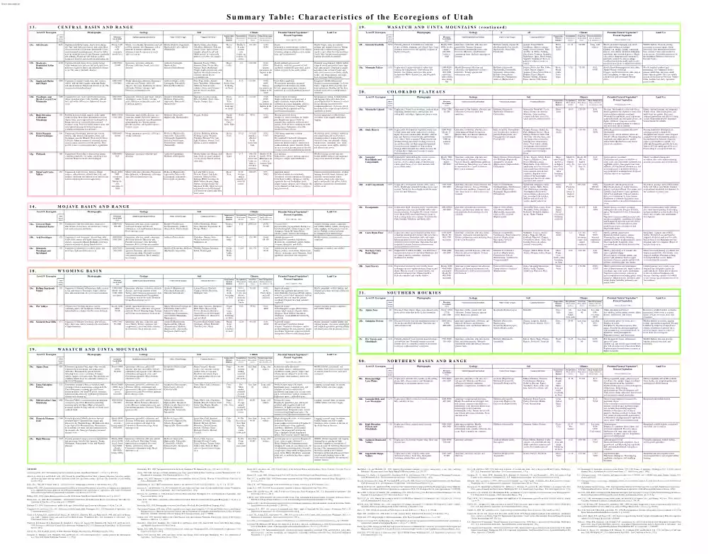
S u m m a r y Ta b l e : C h a r a c t e r i s t i c s o f t h e E c o r e g i o n s o f U t a h 13. CENTRAL BASIN AND RANGE Physiography Level IV Ecoregion Area (square miles) 19. Geology Elevation/ Local Relief (feet) Surficial material and bedrock Soil Order (Great Groups) Common Soil Series Climate Temperature/ Moisture Regimes Precipitation Mean annual (inches) Frost Free Mean annual (days) Mean Temperature January min/max; July min/max, (∞ F) Potential Natural Vegetation*/ Present Vegetation Land Use Mostly 42004650/ 0-50; commonly nearly level Mostly very alkaline, Quaternary mud and Mostly Aridisols (Aquisalids, salt flat deposits; also Quaternary eolian Haplocalcids); also Alfisols material, lacustrine sediments, and (Natrustalfs) alluvium. Isolated exposures of much older rock occur. Mostly Saltair; also Jordan, Lakeshore, Bramwell. Soils are mostly clayey, light-colored, strongly affected by salt and alkali, poorly- or very poorlydrained, and often
salt-crusted. Mesic/ Aridic Mostly 48; some eastern sites receive up to about 12 inches 110-190 12/40; 50/94 Desert/ Vegetation is mostly absent; scattered, extremely salt-tolerant plants occur such as salicornia, saltgrass, alkali sacaton, iodine bush, and/or greasewood. Mostly barren; some recreational, military, and industrial activity. Tailing ponds, dikes, salt processing plants, smelters, and refuse facilities are found locally. Very limited grazing potential Largely unsuitable as cropland. 13b. ShadscaleDominated Saline Basins 8110 Unglaciated. Arid nearly flat to gently sloping valley bottoms, lake terraces, fan skirts, and lower hillslopes. Scattered dunes and ephemeral streams occur. The area is internally-drained 4300-5600/ 25-600 Quaternary lacustrine sediments, alluvium, colluvium, basalt, and eolian deposits. Aridisols (Natrargids, Haplocalcids), Entisols (Torriorthents) Skumpah, Tooele, Uffens, Goshute, Dera, Uvada, Hiko Springs, Drum, Biddleman, Timpie.
Light-colored soils with high salt and alkali content are common and are dry for extended periods. Mesic/ Aridic 4-9 100-190 12-44; 48/94. January maximums are highest in the south Mostly saltbush-greasewood/ Shadscale, winterfat, greasewood, bud sagebrush, bottlebrush squirreltail, and/or Indian ricegrass. In the south: galleta Primarily rangeland and wildlife habitat. Large livestock and poultry farms raise hogs and chickens. Cropland is usually uncommon due to lack of water and salty soils; however, near Delta, alfalfa, barley, corn silage, pasture, and sugar beets are grown under irrigation. 13c. 9394 Unglaciated. Semiarid basin rims, lake terraces, valleys, alluvial fans, bajadas, mountain flanks, and stream terraces. Ephemeral streams occur The ecoregion is internally-drained. 4400-7400/ 100-2600 Mostly Quaternary alluvium, Quaternary colluvium, and Tertiary valley-fill deposits; also some Quaternary lacustrine sediments, Tertiary volcanics, and Paleozoic sedimentary
rocks. Aridisols (Haplocalcids, Calciargids, Natrargids), Entisols (Torriorthents) Hiko Peak, Garbo, Amtoft, Sevy, Taylorsflat, Biblesprings, Ashdown. Soils are light colored, often coarse-textured, and are dry for extended periods. Mesic/ Aridic often bordering on Xeric 8-12 10/44; 46/94. January maximums are highest in the south Great Basin sagebrush/ Wyoming big sagebrush; perennial bunchgrasses and herbaceous plants become progressively more common northward as available moisture increases. Rangeland, wildlife habitat, and localized irrigated agriculture. In Sevier Valley, irrigated alfalfa, feed lots, and dairy operations. Grazing and fire have reduced native grasses and promoted cheatgrass. Quaternary colluvium and basalt. Tertiary sedimentary rocks, Tertiary volcanic rocks, Paleozoic sedimentary rocks, and Cambrian quartzite. Entisols (Torriorthents), Mollisols (Calcixerolls, Argixerolls, Durixerolls, Haploxerolls) Eaglepass, Lodar, Logring, Kyler, Ubehebe, Nevu, Uana,
Segura, Cropper, Itca MesicFrigid/ Xeric sometimes bordering on Aridic 10-22 10/48; 46/96. January maximums are highest in the south Juniper-pinyon woodland/ Juniper and pinyon woodland and, at higher elevations, mountain brush (including mountain mahogany, cliffrose, and western serviceberry). Sagebrush (including black sagebrush and big sagebrush) codominates. Rangeland, woodland, wildlife habitat, and logging. Large areas have been cleared in an effort to increase livestock forage. Grazing has depleted the woodland understory of grasses, which has reduced fire frequency and allowed sagebrush to invade. Frigid/ Mostly Xeric; also Cryic/ Xeric, Udic 25-40+ 8/32; 44/80 Western spruce-fir forest/ Douglas-fir, aspen, subalpine fir, limber pine, Engelmann spruce, white fir, mountain big sagebrush, and associated grasses. Trees are most common on northfacing slopes Carbonates extend the elevational limits of trees. Summer rangeland, wildlife habitat, recreation, water supply, and
limited logging. 5498 Unglaciated. Low, rocky fault-block mountains, 13d. Woodland- and ridges, mountain slopes, hills, foothills, alluvial Shrub-Covered Low fans, and valley-fill terraces. Ephemeral streams Mountains 5000-9000/ 200-3400 occur. 13e. 13f. High Elevation Carbonate Mountains Moist Wasatch Front Footslopes 13g. Wetlands 13i. Malad and Cache Valleys 14. 116 Mollisols (Palecryolls, Haplocryolls, Haploxerolls) Flygare, Podmor 50-90 Partially glaciated. High, rugged, rocky, northsouth trending, fault-block mountains with steep slopes. Some areas, especially in the Deep Creek Range, have been extensively glaciated and moraines occur. Some perennial streams occur, but only limited amounts of surficial water are available on limestone and dolomite. 8000-12100/ 1000-4100 890 Unglaciated. Footslopes, alluvial fans, stream terraces, lake terraces, lake plains, deltas, and floodplains near the Wasatch Front and the Great Salt Lake. Many mountain-fed perennial
streams occur in shrub- and tree-covered canyons. They provide water to municipalities and to agriculture. 4200-5400/ 10-500 Mostly Quaternary alluvium, colluvium, or lake sediments. Mollisols (Haploxerolls, Argixerolls, Calcixerolls, Calciaquolls, Haplustolls), Entisols (Torrifluvents, Torriorthents), Alfisols (Natrustalfs) Kidman, Bingham, Kilburn, Fielding, Layton, Wasatch, Chipman, Pleasant Vale, Salt Lake, Kirkham, Sunset, Lasil, Genola, Linoyer, Medburn Mesic/ Xeric 10-22 145-220; climate is affected by the Great Salt Lake 16/42; 53/93 Great Basin sagebrush, saltbushgreasewood/ Big sagebrush, bluebunch wheatgrass, western wheatgrass, sand dropseed, gumweed, Indian ricegrass, rabbit brush, needleandthread, and/or winterfat. Shruband tree-covered canyons descend into the ecoregion from the neighboring mountains. Widespread urban, suburban, industrial, and commercial activity. Elsewhere, irrigated cropland, irrigated pastures, livestock farms, and orchards. Alfalfa, wheat,
barley, vegetables, corn, sugar beets, peaches, pears, apples, apricots, and cherries are grown. 360 Unglaciated. Nearly flat to depressional terrain containing brackish, very saline, and fresh water wetlands. Water levels are often managed 4200-4650/ 0-25 Quaternary lacustrine sediments and alluvium. Aridisols (Aquisalids), Mollisols (Calciaquolls) Mostly Saltair; also Refuge, Salt Lake. Soils are poorly-drained or very poorly-drained and are often salty. Mesic/ Aquic 6-17 140-170 near the Great Salt Lake; as short as 115 days elsewhere Mostly 14/38; mostly 56/94. Minimums are lower in western Juab County Tule marshes/ Baltic rushes, cattails, burreed, common reed grass, sedges, and/or bullrushes. Wildlife habitat, several state and federal wildlife refuges, and rangeland. Large concentrations of birds occur. Unglaciated. Lake terraces, benches, stream terraces, valley bottoms, alluvial fans, hills, and foothills. Mountain-fed streams occur and provide water to
municipalities and to agriculture. Mostly 42005400; maximum 6000/ Mostly 10200; sometimes to 1000 Mostly Quaternary alluvium, Pleistocene lake sediments, or Quaternary colluvium. Also Tertiary sedimentary rock. Mollisols (Haploxerolls, Argixerolls, Calcixerolls, Calciaquolls, Natrixerolls, Calciustolls, Argiustolls) In Cache Valley: Logan, Trenton, Parleys, Salt Lake, Greenson, Nibley, Collett, Kidman, Ricks, Lewiston. In Malad Valley: Kearns, Hupp, Parleys, Sterling, Honeyville, Greenson, Fridlo. Upper terraces and benches are better drained and freer from soluble salts than lower areas. Mesic/ Xeric 12-24. Average annual snowfall is 60 to 80 inches 100-165 8/35; 50/92 Sagebrush steppe/ On better drained sites: bluebunch wheatgrass, western wheatgrass, bluegrass, Great Basin wildrye, cheatgrass, and big sagebrush. On wet floodplains: reeds, sedges, foxtail, saltgrass, and wiregrass. On poorly-drained low lake terraces: saltgrass and greasewood. Irrigated cropland and
pastures, dryland farming, livestock farms, dairying, and orchards. Alfalfa, barley, wheat, vegetables, silage corn, sugar beets, apples, and peaches are grown. Urban, suburban, commercial, and industrial activity occur. 662 Quaternary glacial drift, alluvium, and colluvium. Mostly Paleozoic limestone, dolomite, and quartzite; also Precambrian metasediments and Tertiary granite, rhyolite, andesite, and basalt. Exposed bedrock occurs. 40-120 M O J AV E B A S I N A N D R A N G E Physiography Level IV Ecoregion Area (square miles) 14a. Creosote BushDominated Basins 516 Unglaciated. Arid low relief area composed of alluvial fans, flood plains, stream terraces, valleys, and scattered mesas and buttes. Geology Soil Elevation/ Local Relief (feet) Surficial material and bedrock 2200-4000/ 100-800 Quaternary alluvium, eolian sediments, and basalt. Jurassic and Triassic sedimentary rock and Permian Limestone. Rock outcrops occur. Entisols (Torrifluvents, Torripsamments), Aridisols
(Petrocalcids, Haplocalcids) Order (Great Groups) Common Soil Series Climate Temperature/ Moisture Regimes Precipitation Mean annual (inches) Frost Free Mean annual (days) Mean Temperature January min/max; July min/max, (∞ F) Thermic/ Aridic 6-10 180-225+ 24/54; 60-100 Tobler, Harrisburg, Pintura Cave, Junction, Toquerville, St. George, Winkel Potential Natural Vegetation*/ Present Vegetation 14b. Arid Footslopes 128 Unglaciated. Arid footslopes, alluvial fans, hills, basalt flows, mesas, and highly dissected, erodible, sparsely vegetated badlands. Badlands yield large amounts of sediment during thunderstorms. 3000-5000/ 1000-2000 Quaternary alluvium, basalt, colluvium, and eolian deposits. Mesozoic and Permian sedimentary rock including limestone. Rock outcrops are common Aridisols (Petrocalcids) Curhollow, Pastura, Veyo, Winkel. Indurated carbonate hardpans occur. Mesic/ Aridic 10-12 155-180 20-48/ 68-100 Saltbush-greasewood/ Wyoming big sagebrush,
blackbrush, Mormon tea, yellowbrush, galleta, Indian ricegrass, cheatgrass, and cholla. Wildlife habitat, recreation, and rangeland. 14c. 103 Unglaciated. Mountains, mountain slopes, and mesa tops. Ephemeral streams occur 4000-7800/ 200-2700 Quaternary colluvium. Paleozoic quartzite, limestone, and calcareous sandstone and shale. Precambrian schist with granitic intrusions. Rock outcrops are common. Entisols (Ustorthents), Mollisols Welring, Tortugas, Motoqua, (Haplustolls, Argiustolls) Kolob, Paunsaugunt Frigid, Mesic/ Aridic, Xeric 12-16 120-170 16-44/ 60-96 Juniper-pinyon woodland/ Pinyon, juniper, serviceberry, Gambel oak, cliffrose, manzanita, native bluegrass, black sagebrush, squirreltail, and cheatgrass. Rangeland, recreation, and wildlife habitat. Mountain Woodland and Shrubland 18. 18a. Rolling Sagebrush Steppe Wet Valleys 18d. Semiarid Bear Hills 19. Geology Physiography Area (square miles) 245 173 651 Quaternary colluvium, alluvium, and glacial
drift. Tertiary volcanics, Precambrian metamorphic rocks, and Cenozoic, Mesozoic, and Paleozoic sedimentary rocks. Bedrock outcrops are common. Mollisols (mostly Argixerolls; also Argiustolls, Calcixerolls, Haploxerolls, Palexerolls, Paleustolls) 19g. Mountain Valleys 1351 Unglaciated. Largely unforested valleys that separate the high plateaus. Alluvial fans, low terraces, flood plains, and a few hills occur. Includes the Heber, Kamas, Loa, and Panguitch valleys. 4800-8000/ Usually 25600; 1400 maximum. Valley floors often nearly flat Mostly Quaternary alluvium and colluvium; also Quaternary lacustrine sediments. Tertiary igneous and sedimentary rock. Mollisols (Argixerolls, Haploxerolls, Calciustolls, Argiustolls, Calcixerolls), Entisols (Torriorthents, Torrifluvents, Fluvaquents), Aridisols (Haplocalcids) 20. C O L O R A D O P L AT E A U S Unglaciated. Semiarid rolling plains, hills, cuestas, mesas, and terraces. Footslopes, ridges, alluvial fans, and outwash fans also occur
near mountains. Soil Elevation/ Local Relief (feet) Surficial material and bedrock 5350-9400/ Mostly 1001600; 2000 maximum Quaternary alluvium, colluvium, outwash deposits, and eolian deposits overlie Tertiary and Cretaceous sedimentary rock or partly metamorphosed Precambrian sedimentary rock of the Uinta Mountain Group. Rock outcrops occur Aridisols (Haplocalcids, Calciargids, Haplargids), Entisols (Torriorthents) Order (Great Groups) Common Soil Series Climate Temperature/ Moisture Regimes Precipitation Mean annual (inches) Frost Free Mean annual (days) Mean Temperature January min/max; July min/max, (∞ F) FrigidMesic/ Aridic bordering on Ustic 10-16. Proximity to mts. and altitude increases precipitation 50-100 8/36; 48-84. Cold winters and mild summers 55-90 Luhon, Grieves, Fluetsch, Clapper, Mivida, Brownsto, Dahlquist, Yarts Unglaciated. Cold high elevation valleys containing nearly flat floodplains and low terraces. Bottomlands are characterized by many
wetlands. Mostly 60006600/ 10-200 Mostly Quaternary alluvium; also Quaternary loess, colluvium, and glacial outwash. West of Flaming Gorge, Tertiary and Cretaceous sedimentary rock occurs. Mostly Mollisols (Calciaquolls, Calciustolls, Calcixerolls), Entisols (Ustifluvents, Torrifluvents, Torriorthents); also Aridisols (Haplargids, Haplocalcids) Bear Lake, Saleratus, Dahlquist, Rich, Wader, Bereniceton, Cowco, Bockston, Brownsto. Some soils are rich in organic matter. Others are affected by salt and alkali. Frigid/ Ustic, Aquic, Aridic bordering on Ustic 9-12 Unglaciated. Semiarid footslopes, alluvial fans, hills, ridges, and valleys located in the rainshadow of high mountains. 6350-7700/ 50-1200 Quaternary alluvium, colluvium, and loess. Mostly Tertiary sandstone and conglomerate; also some shale, siltstone, and limestone. Rock outcrops occur Aridisols (Haplocalcids, Haplocambids), Entisols (Torriorthents), Mollisols (Haploxerolls, Argixerolls), Inceptisols (Calcixerepts)
Pancheri, Kearl, Cutoff, Solak, Woodpass, Alhark, Richville, Thatcher, Jebo, Falula Frigid/ Xeric, Aridic bordering on Xeric 10-16 90-120 Potential Natural Vegetation*/ Present Vegetation Physiography Level IV Ecoregion Area (square miles) Physiography Area (square miles) 19a. Alpine Zone 519 Geology Soil Elevation/ Local Relief (feet) Surficial material and bedrock Extensively glaciated. Very high, often severely exposed ridges, mountains, and peaks above timberline. Dominated by glacial features including horns, aretes, moraines, U-shaped valleys, cirques, and many tarns. Wet meadows are common. Alpine areas are especially extensive in the Uinta Mountains. About 1100013528/ 50-2500 Quaternary colluvium, glacial till deposits, alluvium, and rubble. Tertiary sedimentary and igneous rocks, Mesozoic sedimentary and igneous rocks, and Precambrian quartzite. Many bedrock exposures occur. Inceptisols (Dystrocryepts, Cryaquepts) Order (Great Groups) 0/28; 44/80 Sagebrush
steppe/ Tufted hairgrass, sedges, Baltic rushes, cattails, alkali sacaton, saltgrass, alkali bluegrass, basin wildrye, bluebunch wheatgrass, needleandthread, and/or big sagebrush. Irrigated hayland, pasture, rangeland, and wildlife habitat. 8/28; 44/84 Sagebrush steppe/ Big sagebrush, bitterbrush, Indian ricegrass, bluebunch wheatgrass, and/or needleandthread. On rock outcrops: juniper woodlands. Vegetation is denser on northfacing slopes than on south-facing slopes Mostly rangeland, wildlife habitat, and irrigated pasture; also some nonirrigated and irrigated agriculture growing alfalfa, and small grains. Oil production occurs Precipitation Mean annual (inches) Frost Free Mean annual (days) Mean Temperature January min/max; July min/max, (∞ F) Mirror, Vasquez, Haverly. Acidic, very gravelly to stony, shallow soils are common. Meadows have much deeper soils than mountain slopes and are often wet. Cryic/ Udic 30-50+. Average annual snowfall exceeds 300 inches Less than 40
Long, cold winters Cryic/ Udic 30+. Mean annual snowfall exceeds 150 inches Less than 40 Potential Natural Vegetation*/ Present Vegetation Barren and alpine meadows/ Low shrubs, mosses, cushion plants, wildflowers, alpine grasses, sedges, and willows that are adapted to acidic soils, cold winters, short summers, and/or wet soils. Wildlife habitat, pastureland, and recreation. Snow cover is a major source of summer water for lower, more arid ecoregions. Long, cold winters Mostly western spruce-fir forest/ Engelmann spruce, lodgepole pine, and subalpine fir with an understory of huckleberry and sedge; also, locally, some aspen. At timberline: stunted, subalpine fir, Englemann spruce, and limber pine. Logging, seasonal range, recreation, wildlife habitat, and water supply. About 1000011000; deep canyons are lower/ 100-1000 Quaternary glacial till, colluvium, and alluvium. Tertiary sedimentary and igneous rocks, Mesozoic sedimentary and igneous rocks, and Precambrian quartzite.
Rock outcrops occur. Inceptisols (Dystrocryepts, Eutrocryepts), Alfisols (Glossocryalfs) Uinta, Mirror Lake, Duchesne, Marsell, Scout 19c. 1486 Glaciated. Middle elevation forested mountainous ecoregion in the Uinta Mountains containing moraines and a few lakes. Many good quality, perennial streams in deep canyons are found on its southern flank. 8000-10000/ 400-2000 Quaternary glacial till, colluvium, and alluvium. Mostly Tertiary sedimentary rocks, Mesozoic sedimentary rocks, and Precambrian quartzite; also some Tertiary igneous rocks. Alfisols (Glossocryalfs, Haplocryalfs), Inceptisols (Dystrocryepts, Eutrocryepts), Mollisols (Argixerolls, Haplocryolls, Argicryolls, Palecryolls) Uinta, Mirror Lake, Duchesne, Frigid, Skutum, Marsell, Namon, Scout, Cryic/ Lucky Star, Manila, Henefer, Udic, Xeric Yeates Hollow, Sessions 20-30. Average annual snowfall exceeds 70 inches 40-90 Long, cold winters Douglas-fir forest/ Douglas-fir, ponderosa pine, and aspen parkland with a
sagebrush and forb understory. In higher and drier areas: mountain brush. In riparian areas: willow, cottonwood, and Engelmann spruce. In northern Uinta Mountains: lodgepole pine. Logging, seasonal range, recreation, wildlife habitat, and water supply. 3560 Partially glaciated. Middle elevation forested mountain slopes, mountain tops, ridges, and plateaus in the Wasatch Range. Moraines and lakes occur. East of the Wasatch divide, the terrain is more rolling, less steep, and less rugged than on the western side. Many good quality, perennial streams occur. Mostly 800010000; lower on northfacing slopes/ 400-2000 Quaternary glacial till, colluvium, and alluvium. Sedimentary and metamorphic rocks are common and range from Cenozoic to Proterozoic in age. Rock outcrops occur. Mollisols (Argicryolls, Palecryolls, Haplocryolls), Alfisols (Palecryalfs, Haplocryalfs, Glossocryalfs) Lucky Star, Cluff, Senchert, Bickmore, Poleline, Fitzgerald, Roundy, Daybell, Skylick, Mortenson, Broad
Canyon, Skutum, Clayburn, Faim, Embargo, Condie, Elwood, Croydon Cryic/ Udic 16-50+. East side is drier than west side. Deep winter snow pack Less than 40-80 Long, cold winters Mostly Douglas-fir forest; in south: sprucefir-Douglas-fir forest/ Aspen parkland with scattered Douglas-fir and an understory of big sagebrush, snowberry, elderberry, and mountain grasses. On cirques and north-facing slopes: subalpine fir and Engelmann spruce. Near streams: willows and birch Logging, seasonal range, recreation, wildlife habitat, and water supply. Grazing is more common to the east of the divide than to the west. 3015 Partially glaciated. Largely forested high plateaus and mountains. Includes the Aquarius, Awapa, Markagunt, Paunsaugunt, Sevier, and Wasatch plateaus. Mostly 8000about 11000; locally lower than 7000/ Mostly 400-3000; locally 4000+ Quaternary colluvium, alluvium, glacial drift, and basalt. Flat-lying, Tertiary igneous rock is common; also some Tertiary sedimentary rocks and
Cretaceous sedimentary rocks. Rock outcrops occur. Mollisols (Argicryolls, Haplocryolls, Palecryolls, Calcicryolls), Alfisols (Glossocryalfs), Inceptisols (Eutrocryepts) Forsey, Faim, Sessions, Behanin, Elwood, Condie, Scout, Nielsen, Tatiyee, Jemez, Parkay, Seth, Pahreah. Many soils are derived from volcanic rock. Cryic/ Udic 16-40+. Deep winter snow pack Less than 40-80 Arizona pine forest, spruce-fir-Douglas-fir forest, western spruce-fir forest/ Mostly Douglas-fir, Englemann spruce, subalpine fir, white fir, and limber pine. At low elevations: ponderosa pine. On southfacing slopes in the southern high plateaus: aspen. In the Henry Mountains: mountain brush and, on north-facing slopes, sprucefir forest. Wildlife habitat, rangeland, and logging. Seasonal heavy grazing on high meadows. Logging occurs outside of protected areas. In the Henry Mountains, grazing is the dominant land use and timber harvesting is very limited. Snowpack on the high plateaus provides irrigation and
drinking water to the lower valleys during the late-spring and summer seasons. SOURCES: Daubenmire, R.F, 1943, Vegetational zonation in the Rocky Mountains: The Botanical Review, v IX, no 6, p 325-393 Armstrong, D.M, 1977, Distributional patterns of mammals in Utah: Great Basin Naturalist, v 37, no 4, p 457-474 Downs, J.M, 1990, Soil survey of Henry Mountains area, Utah – parts of Garfield, Kane, and Wayne counties: Washington, DC, US Department of Agriculture - Soil Conservation Service, 231 p. Arno, L.A, Albee, BJ, and Wyckoff, AM, 1980, Flora of the central Wasatch Front, Utah - a manual of the ferns, fern allies, conifers, and flowering plants growing without cultivation in Salt Lake and Davis counties: Salt Lake City, University of Utah Printing Service, 663 p. Long, cold winters Carley, J.A, Jensen, EH, Campbell, LB, Barney, M, Fish, RH, Chadwick, RS, and Winkelaar, P, 1980, Soil survey of Morgan area, Utah – Morgan County and eastern part of Weber County: Washington,
D.C, US Department of Agriculture - Soil Conservation Service, 300 p. Chadwick, R.S, Barney, ML, Beckstrand, D, Campbell, L, Carley, JA, Jensen, EH, McKinlay, CR, Stock, SS, and Stokes, HA, 1975, Soil survey of Box Elder County, Utah, eastern part: Washington, D.C, US Department of Agriculture - Soil Conservation Service, 223 p. Graham, E.H, 1937, Botanical studies in the Uinta Basin of Utah and Colorado: Pittsburgh, Pennsylvania, Annals of the Carnegie Museum, v. XXVI, no 1, p 26-81 Greer, D.C, Gurgel, KD, Wahlquist, WL, Christy, HA, and Peterson, GB, 1981, Atlas of Utah: Provo, Utah, Weber State College, and Brigham Young University Press, 300 p. Chronic, H., 1990, Roadside geology of Utah: Missoula, Montana, Mountain Press Publishing Company, 326 p Hansen, D.T, 1989, Soil survey of Grand County, Utah, central part: Washington, DC, US Department of Agriculture - Soil Conservation Service, 200 p. Cronquist, A., Holmgren, AH, Holmgren, NH, and Reveal, JL, 1972, Intermountain flora
- vascular plants of the intermountain west: New York, Hafner Publishing Company, v. 1, 270 p Hansen, D.T, and Fish, RH, 1993, Soil survey of San Juan County, Utah, central part: Washington, DC, US Department of Agriculture - Soil Conservation Service, 208 p. Wildlife habitat, livestock grazing, recreation, and water supply. Some intensively used rangeland areas have been cleared of trees and reseeded to exotic grasses. Oil production occurs in the Overthrust Belt near Pineview in Summit County. Genola, Notter, Ant Flat, Tebbs, Tridell, Birdow, Sanpete, Arapien, Codley, Yeates Hollow, Bruman, Descot, Manila, Krueger, Vicking, Alldown, Utaba, Dacore, Villy, Stoda MesicFrigid/ Aridic, Xeric, Aquic 5-24 70-100 4/42; 45/90 Mostly Great Basin sagebrush; also some Juniper-Pinyon woodland/ Grasses, sagebrush common; some pinyon, and Utah juniper. In riparian areas, cottonwoods and introduced Russian olives. Mostly irrigated cropland and pastureland; also rangeland. Native grasses,
alfalfa hay, and some small grain crops are grown. They are mainly used as winter feed for livestock. Turkey farms, feedlots, and dairy operations occur locally. Potential Natural Vegetation*/ Present Vegetation Land Use Soil Order (Great Groups) Common Soil Series Climate Temperature/ Moisture Regimes Precipitation Mean annual (inches) Frost Free Mean annual (days) Mean Temperature January min/max; July min/max, (∞ F) *Source: Kuchler, 1964 Quaternary eolian deposits, alluvium, and colluvium. Cretaceous shale and sandstone. Mollisols (Argiustolls, Haplustolls, Paleustolls, Calciustolls) Monticello, Northdale, Ucolo, Abajo, Scorup, Hovenweep, Montvale. Deep, mediumtextured soils have formed in sandy and silty eolian material. Mesic/ Ustic 10-17 120-130 8/36; 50/88 On deep, fine-textured, eolian soil: Great Basin sagebrush. On shallow or stony soils: scattered pinyon-juniper woodland/ Wyoming big sagebrush, black sagebrush, scattered juniper, and associated grasses.
At higher elevations, grass out-competes sagebrush and pinyon-juniper woodland if not stressed by fire or grazing. Mostly dryland farming, and rangeland. Winter wheat, other small grains, and pinto beans are grown. Also some irrigated pastureland and alfalfa farming occurs. Shrublands provide important winter habitat for wildlife. 20b. Shale Deserts 3486 Unglaciated. Arid sparsely vegetated, nearly level to hilly plains and basins with actively eroding, highly dissected, rounded hills. Benches, alluvial fans, and buttes are found locally and badlands occur where shale is exposed. Water readily runs off shale during rainstorms resulting in erosion, terrain dissection, and high suspended sediment concentrations in stream flow. Salt leaching strongly affects downstream salinity levels in the Colorado River. Ephemeral streams in deeply incised arroyos occur. 4000-5000/ Mostly 25500; maximum 1000 on scattered buttes Quaternary colluvium, alluvium, and eolian material. Mostly Cretaceous
Mancos Shale and Jurassic Morrison Formation. Rock outcrops occur Entisols (mostly Torriorthents; also Torrifluvents), Aridisols (mostly Haplocalcids; also Calcigypsids, Calciargids, Petrocalcids) Chipeta, Persayo, Hanksville, Farb, Killpack, Ravola, Mack, Billings, Robroost. Soils with clay loam, silty clay loam, and clay textures have formed in material from saline marine shales. They contain soluble salt, gypsum, and selenium. Active erosion and rapid runoff contribute salt to Colorado River. Mesic/ Aridic 5-8 120-160 6/40; 56/96 Saltbush-greasewood, galleta-three awn shrubsteppe/ Sparse cover of mat saltbush, shadscale, Nuttall saltbush, blackbrush, Wyoming big sagebrush, associated grasses, and/or annual forbs. Badland areas are almost devoid of vegetation. Grazing dominates although stock carrying capacity is limited. On floodplains and terraces: some irrigated cropland occurs and primarily produces hay and grain for livestock. Carrying capacity for wildlife is typically
low although deep gullies provide sheltered habitat. Oil and natural gas wells occur Coal mining is an important land use. 20c. 15103 Unglaciated. Semiarid benches, mesas, cuestas, alluvial fans, hillslopes, cliffs, arches, and canyons. A few isolated peaks of limited areal extent occur. Areas of low relief alternate with areas of high relief. Mostly 50007500; locally higher/ 100-2000 Quaternary colluvium, alluvium, and eolian material. Tertiary, Cretaceous, Jurassic, Triassic, and Permian sandstone and limestone. Monoclines occur and can be surrounded by a “reef” of rimrock. Bare rock is common. Mostly Entisols (Torriorthents); also Mollisols (Haplustolls, Argiustolls), Aridisols (Haplocalcids, Haplocambids, Calciargids) Atchee, Towave, Strych, Rizno, Wayneco, Flynncove, Skos, Begay, Mivida, Cahona, Windwhistle. Soils with fine sandy loam and very fine sandy loam texture have formed in eolian deposits derived from sandstone. Depth of soil is influenced by topographic
position and the rates of eolian deposition and erosion. Mesic; some Frigid and Cryic on highest sites/ Ustic; also, Aridic often bordering on Ustic Mostly 814; on highest sites: 2025 Mostly 80160; on highest sites: less than 50 days 4/44; 50/64 Juniper-pinyon woodland/ Utah juniper and pinyon on shallow or stony soils; also some black sagebrush, big sagebrush, galleta, blue grama, four-wing saltbush, and blackbrush, Mormon tea, and associated grasses. At higher elevations: sage parkland or mountain brush. Exposed rock has little or no vegetation. Mostly woodland grazing and recreation; also some uranium mining, uranium processing, and oil production. 20d. Arid Canyonlands 5093 Unglaciated. Arid narrow chasms, cliffs, valley floors, floodplains, structural benches, mesas, and cuestas. Terrain has been deeply eroded by major rivers and their tributaries. 3200-5000/ 200-1800 Quaternary alluvium, eolian deposits, and colluvium. Jurassic, Triassic, Permian, Pennsylvanian
sandstone, limestone, and shale. Bare rock (ie slick rock) is very common. Entisols (Torriorthents, Torripsamments, Torrifluvents), Aridisols (Haplocalcids, Haplargids, Haplocambids, Petrocalcids) Moenkopie, Sheppard, Nakai, Myton, Arches, Mido, Rizno, Farb, Hoskinnini, Limeridge, Thoroughfare, Pennell. On canyon slopes, colluvial soils have developed. On benches, shallow soils are found. In washes, deeper soils occur. Mesic/ Aridic 5-8 Precipitation is lowest in deepest canyons 160-220+. 16/48; 60/100. Mild winters Blackbrush, saltbush-greasewood/ Blackbrush, shadscale, Indian ricegrass, galleta, fourwing saltbush, blue grama, mat saltbush, sand dropseed, sand sagebrush, and/or bud sagebrush. Exposed rock has little or no vegetation. In deep canyons: blackbrush is common. In riparian areas: extensive stands of introduced tamarisk can occur. Recreation, grazing, and wildlife habitat. In the salt valleys near Moab: irrigated cropland and residential development. In the
southeast: oil production. 20e. Escarpments 4144 Unglaciated. High, dissected, partly wooded cliffs, escarpments, mesa tops, and breaks with a wide elevational range. Ecoregion 20e is most extensive in the Book Cliffs and Grand Staircase areas as well as along major river canyons. It includes the Pink, Straight, Vermilion, and Book cliffs. 5000-10000/ 500-3000 Quaternary alluvium and colluvium. Tertiary and Mesozoic sandstone, shale, and limestone. Rock outcrops are very common. Entisols (Torriorthents, Ustorthents), Mollisols (Haplustolls, Argicryolls, Calcicryolls), Aridisols (Haplocalcids) Travessilla, Gerst, Syrett, Podo, Thedalund, Cabba, Senchert, Batterson, Bookcliff, Shalako, Atchee, Ruko, Pahreah Mesic, Frigid, Cryic/ Ustic often bordering on Aridic 8-30 40-150 8/48; 50/96 Juniper-pinyon woodland, mountain mahogany-oak scrub, Douglas-fir forest, spruce-fir-Douglas-fir forest, Arizona pine forest/ Vegetation varies according to aspect and moisture availability.
Scrubland, woodland, and Douglas-fir are most common. Above about 9000 feet elevation and on some north-facing slopes: subalpine fir and Engelmann spruce. Mostly recreation and wildlife habitat; also some limited grazing. Coal mining and gas production occurs locally. Steep slopes and unstable soils limit human development. 20f. Uinta Basin Floor 2615 Unglaciated. Arid saucer-shaped synclinal basin containing mountain-fed streams, alluvial terraces, outwash terraces, floodplains, hills, and ridges. Mesas and benches occur locally and alternate with lower, more arable land. High dissolved and suspended sediment loads are common water quality problems in its rivers. 4300-6400/ Mostly 50800; 1200 maximum Quaternary colluvium, alluvium, eolian deposits, and coarse outwash deposits. Tertiary sedimentary rocks including those of the Uinta Formation. Entisols (Torriorthents, Torrifluvents, Torripsamments), Aridisols (Haplocalcids, Natrargids), Vertisols (Haplotorrerts) Walknolls,
Casmos, Atchee, Denco, Tipperary, Mivida, Fruitland, Montwel, Clapper, Green River, Motto, Turzo. Salt leaching from soils affects surficial water quality. Mesic/ Aridic 5-8 115-140. Winter inversions create cold winter conditions 0/32; 50/92. Seasonal temperature extremes Mostly saltbush-greasewood/ Shadscale, Indian ricegrass, galleta, Wyoming big sagebrush, fourwing saltbush, winterfat, needleandthread, and/or black sagebrush. In riparian areas: cottonwood and introduced Russian olive trees. Rangeland, cropland, and wildlife habitat. On basin floors and benches: irrigated alfalfa hay and corn for cattle. Runoff from Uinta Mountains provides abundant water for irrigation. Major oil and gas fields occur. 20g. Northern Uinta Basin Slopes 707 Unglaciated. Southern foothills, outwash terraces, and glaciated canyons of the Uinta Mountains that are characterized by numerous, perennial, mountain-fed streams. 5500-9200/ 100-2600 Quaternary outwash deposits, colluvium, alluvium,
and eolian deposits. Tertiary sedimentary rocks. Mollisols (Calciustolls), Aridisols (Haplocalcids, Petrocalcids), Entisols (Torriorthents, Torrifluvents, Torripsamments) Clapper, Tridell, Hillto, Tyzak, Atchee, Mespun, Ashley, Reepo Mesic, Frigid/ Ustic, Aridic often bordering on Ustic 8-18 100-130 4/28; 50/84 Mostly juniper-pinyon woodland; also some sagebrush steppe/ Pinyon-juniper woodland, shrubs, and grasses with mountain brush at upper elevations. Canyons contain cottonwoods, willows, ponderosa pine, and shrubs. Mostly livestock grazing, woodland, and irrigated pastureland; also, locally, some irrigated cropland. Phosphate mining and oil production occurs. Indian reservation land is extensive. 20h. Sand Deserts 1634 Unglaciated. Arid nearly level to hilly basins containing sparsely vegetated plains, terraces, and dunes. Flat-top benches are found locally, and ephemeral streams occur. Channel depth is bedrock-controlled and usually shallow. Mostly 40005000; 6000
maximum/ Mostly 50600; 1000 maximum Quaternary eolian deposits and alluvium. Jurassic and Permian sedimentary rock. Characterized by shifting eolian material over bedrock. Entisols (Torriorthents, Torripsamments), Aridisols (Haplocalcids) Nakai, Sheppard, Moenkopie, Moffat, Aneth, Trachute, Sandbench, Wayneco, Mido Mesic/ Aridic 5-8 130-180 10/48; 92/96 Mostly galleta-three awn shrubsteppe; some saltbush-greasewood, juniper-pinyon woodland, and, in the south, blackbrush/ Vegetation, where present, is desert or semi-desert grasses (including galleta, sand dropseed, indian ricegrass, and three awn), desert shrubs (including sandsage), and annual forbs. Limited grazing; also, locally, some irrigated hay and grain is grown for cattle and sheep. Arable land is limited to alluvial soils on floodplains and terraces. Carrying capacity for wildlife is low. Oil and gas production occurs in the southeast. 21. SOUTHERN ROCKIES Potential Natural Vegetation*/ Present Vegetation Land Use
Semiarid Benchlands and Canyonlands Physiography Area (square miles) Soil Geology Elevation/ Local Relief (feet) Surficial material and bedrock Order (Great Groups) Common Soil Series Climate Temperature/ Moisture Regimes Precipitation Mean annual (inches) Frost Free Mean annual (days) Mean Temperature January min/max; July min/max, (∞ F) *Source: Kuchler, 1964 21a. Alpine Zone 19 Glaciated. Steep slopes, ridges, and exposed, rocky peaks above timberline in the La Sal mountains. About 1150012720/ 400-1200 Quaternary rubble, glacial drift, and colluvium. Tertiary intrusive igneous rocks. Many rock outcrops Inceptisols (Dystrocryepts) Meredith Cryic/ Udic 32+. Deep winter snow pack Less than 40 Less than 6/36; less than 50/76 Alpine meadows and barren/ Low shrubs, cushion plants, mosses, alpine grasses, wildflowers, and sedges. Recreation, wildlife habitat, and native pastureland. Snow cover is a major source of water for lower, more arid ecoregions. 21b.
Subalpine Forests 108 Glaciated. Heavily forested mountainous terrain in the La Sal and Abajo Mountains. Moraines and outwash fans occur. 8800-about 11500/ 400-2100 Quaternary glacial drift, colluvium, and alluvium. Mesozoic and Paleozoic sedimentary rocks and Tertiary intrusive igneous rocks. Mollisols (Palecryolls, Haplocryolls), Inceptisols (Dystrocryepts), Alfisols (Haplocryalfs) Flygare, Leighcan, Skylick, Broad Canyon, Namon, Toone Cryic/ Udic 24-40 Less than 70 Less than 8/36; 52/84 Southwestern spruce-fir forest, pineDouglas-fir forest/ Subalpine fir, Engelmann spruce, blue spruce, Douglas-fir, and aspen parkland with an understory of mountain brush. At timberline: stunted subalpine fir, Englemann spruce, and limber pine. Wildlife habitat, recreation, logging, mining, and summer rangeland. Grazing is limited by lingering snowpack and climatic conditions in general. Snow cover is a major source of water for lower, more arid ecoregions. 21c. 238 Partially
glaciated. Low, forested mountain slopes and outwash fans. Perennial streams occur but summer flow is commonly reduced by diversions to irrigate cropland in lower ecoregions. 7500-9000/ 100-1500 Quaternary colluvium, alluvium, glacial drift, and eolian deposits. Mesozoic sedimentary rocks and Tertiary intrusive igneous rocks. Mollisols (Haplustolls, Argiustolls) Falcon, Herm, Toone, Flygare, Harpole, Bookcliff, Tomasaki Frigid/ Ustic 16-25 Less than 80 10/36; 54/88 Pine-Douglas-fir forest, southwestern spruce-fir forest/ Gambel oak, and widely spaced ponderosa pine with an understory of mountain brush. Ponderosa pine becomes more common at higher elevations. Wildlife habitat, livestock grazing, logging, mineral extraction, and recreation. Dry Forests and Shrublands NORTHERN BASIN AND RANGE Physiography Level IV Ecoregion Area (square miles) Geology Elevation/ Local Relief (feet) Surficial material and bedrock Soil Order (Great Groups) Common Soil Series Climate
Temperature/ Moisture Regimes Precipitation Mean annual (inches) Frost Free Mean annual (days) Mean Temperature January min/max; July min/max, (∞ F) Potential Natural Vegetation*/ Present Vegetation Land Use *Source: Kuchler, 1964 80a. Dissected High Lava Plains 412 Unglaciated. Alluvial fans, bajadas, gently rolling plains, hills, stream terraces, and floodplains. Ephemeral or intermittent streams occur. 5150-6600/ 100-1200 Quaternary alluvium, colluvium, and volcanic ash. Miocene and Pliocene tuffaceous sediments, mudstone, sandstone, conglomerate, and dacitic tuff. Aridisols (Haplodurids), Mollisols (Calcixerolls, Argixerolls, Haploxerolls) Dahar, Donnardo, Fontreen, Cottonthomas, Bullump, Raftriver, Borvant, Kapod, Tomsherry. Some of the soils have formed in volcanic ash. Mostly Frigid; some Mesic/ Xeric and Aridic bordering on Xeric 11-16 75-140 8/37; 50/86 Mostly sagebrush steppe, juniper-pinyon woodland; also, juniper steppe woodland/ Wyoming and basin big
sagebrush, bluebunch wheatgrass, western wheatgrass, Idaho fescue, basin wildrye, needleandthread, Nevada bluegrass, and Utah juniper. Some areas have been cleared and reseeded to crested wheatgrass. Mostly rangeland and wildlife habitat. Some barley, oat, irrigated pastureland, and irrigated alfalfa farming. 80b. Semiarid Hills and Low Mountains 479 Unglaciated. Shrub-covered or wooded mountains, hills, and alluvial fans. 5800-9000/ 400-1800 Quaternary colluvium and alluvium. Mostly Precambrian metamorphic rock with granitic intrusions and Paleozoic sedimentary rock; also some Ordovician metamorphic rocks, Cambrian metamorphic rocks, Tertiary dacitic tuff, and Tertiary tuffaceous sediments. Rock outcrops occur. Mollisols (Argixerolls, Argicryolls, Haplocryolls, Calcixerolls, Haploxerolls) Bickmore, Broad Canyon, Parkay, Clavicon, Middle, Foxol, Sheep Creek Cryic, Frigid, Mesic/ Xeric 14-30 60-120 8/32; 52/84 Mostly juniper-pinyon woodland; also sagebrush steppe/ Lower
elevations: vegetation is transitional between woodland and sagebrush steppe and includes mountain big sagebrush, bluebunch wheatgrass, and scattered junipers. Medium elevations to about 7000 feet: juniper woodland with an understory of bluebunch wheatgrass and/or sagebrush. Above about 7000 feet: mountain brush. Rangeland and wildlife habitat. 80c. High Elevation Forests and Shrublands 126 Unglaciated. Steep, rugged, partly forested mountains. 7000-9900/ 600-1900 Quaternary colluvium. Mostly Precambrian metamorphic and sedimentary rocks; granitic intrusions also occur. Rock exposures are common Mollisols (Argicryolls) Dateman, Parkay, Nielsen Cryic/ Udic 25-39. Wet winters 30-80 Less than 6/28; 52/76. Cold winters Montane zone/ Douglas-fir, subalpine forest, aspen, and associated sagebrush. On rocky ridges: limber pine. On wide ridge tops: open grasslands. In upper canyons: Engelmann spruce and subalpine fir. Rangeland, wildlife habitat, timberland, watershed, and
recreation. 80h. Saltbush-Dominated Valleys 52 Unglaciated. Arid gently sloping valley floors and alluvial fans. 5200-6000/ 100-400 Quaternary alluvium. Aridisols (Haplocalcids, Natrargids) Declo, Mellor, Darkbull. Lightcolored soils with high salt and alkali content are common and are dry for extended periods. Mesic/ Xeric and Aridic bordering on Xeric 8-12 100-140 15/31; 53/87 Saltbush-greasewood/ Shadscale, bottlebrush squirreltail, black greasewood, and Wyoming big sagebrush. Salt- and drought-tolerant vegetation is common. Primarily rangeland, wildlife habitat, and irrigated agriculture. 80i. 7 Unglaciated. Gently sloping valleys with unforested terraces, basin rims, floodplains, footslopes, alluvial fans, and bajadas. 5000-5400/ 25-200 Quaternary lacustrine deposits and alluvium. Mollisols (Haploxerolls, Argixerolls) Kearns, Parleys, Red Rock Mesic/ Xeric 13-18 100-140 11/32; 50/90 Sagebrush steppe/ Bluebunch wheatgrass, Wyoming big sagebrush, cheatgrass,
and Sandberg bluegrass. Rangeland and non-irrigated wheat, non-irrigated barley, and irrigated alfalfa farming. Sagebrush Steppe Valleys U.S Geological Survey, 1986, Land use and land cover data from 1:250,000- and 1:100,000-scale maps: Reston, Virginia, US Geological Survey. Nielson, W., Erickson, AJ, Kutac, W, Van Camp, RW, and Vest, F, 1980, Soil survey of Navajo Indian Reservation, San Juan County, Utah: Washington, D.C, US Department of Agriculture - Soil Conservation Service, 117 p Swenson, H.K, and Bayer, J, 1992, Soil survey of Panguitch area, Utah – parts of Garfield, Iron, Kane, and Piute counties: Washington, D.C, US Department of Agriculture - Soil Conservation Service, 354 p U.S Geological Survey, various dates, Topographic sheets of Utah (various maps): US Geological Survey, scales 1:100,000 and 1:250,000. Oetking, P., Feray, DE, and Renfro, HB, compilers, 1967, Geologic highway map of the Rocky Mountain region: Tulsa, Oklahoma, American Association of Petroleum
Geologists in cooperation with the U.S Geological Survey, scale approximately 1:2,000,000 Swenson, J.L, Jr, Beckstrand, D, Erickson, DT, McKinley, C, Shiozaki, JJ, and Tew, R, 1981, Soil Survey of Sanpete Valley Area, Utah – parts of Sanpete and Utah counties: Washington, D.C, US Department of Agriculture - Soil Conservation Service, 179 p Utah Agricultural Statistics Service, 1986, Utah Agricultural Statistics 1986: Salt Lake City, Utah State Department of Agriculture Utah Agricultural Statistics Service, and U.S Department of Agriculture - National Agricultural Statistics Service, 102 p Olsen, M.E, LeMoyne, W, Metcalf, JW, and Hutchings, TB, 1962, Soil survey of the San Juan area, Utah: Washington, DC, US Department of Agriculture - Soil Conservation Service, 49 p. Swenson, J.L, Jr, Erickson, DT, McDonaldson, KM, and Shiozaki, JJ, 1970, Soil Survey of Carbon-Emery area: Washington, DC, U.S Department of Agriculture - Soil Conservation Service, 78 p Vest, E.D, 1962, Biotic
communities in the Great Salt Lake Desert: Salt Lake City, University of Utah, Division of Biological Sciences, Institute of Environmental Biological Research, Ecology and Epizoology Series, no. 73, 114 p Preece, S.J, Jr, 1950, Floristic and ecological features of the Raft River Mountains of northwestern Utah: Salt Lake City, University of Utah, unpublished M.S thesis, 103 p Tanner, W.W, 1978, Zoogeography of reptiles and amphibians in the intermountain region: Great Basin Naturalist Memoirs, number 2, p. 43-53 West, N.E, 1988, Intermountain deserts, shrub steppes, and woodlands, in Barbour, MG, and Billings, WD, eds, North American Terrestrial Vegetation: Cambridge, Cambridge University Press, p. 209-230 Reiners, W.A, and Thurston, RC, 1996, Delineations of landtype associations for southwest Wyoming (final report): Laramie, Wyoming, Bureau of Land Management and the University of Wyoming, 131 p. Trickler, D.L, and Hall, DT, 1984, Soil Survey of Fairfield-Nephi area, Utah –
parts of Juab, Sanpete, and Utah counties: Washington, D.C, US Department of Agriculture - Soil Conservation Service, 361 p West, N.E, Provenza, FD, Johnson, PS, and Owens, MK, 1984, Vegetation change after 13 years of livestock grazing exclusion on sagebrush semidesert in west central Utah: Journal of Range Management, v. 37, no 3, p 262-264 Shreve, F., 1942, The desert vegetation of North America: Botanical Review, v VIII, no 4, p 195-246 Trimble, S., 1989, The sagebrush ocean - a natural history of the Great Basin: Reno, University of Nevada Press, 248 p Sigler, W.F, and Sigler, JW, 1996, Fishes of Utah - a natural history: Salt Lake City, University of Utah Press, 375 p Tueller, P.T, Beeson, CD, Tausch, RJ, West, NE, and Rea, KH, 1979, Pinyon-juniper woodlands of the Great Basin - distribution, flora, vegetal cover: Ogden, Utah, U.S Department of Agriculture - Forest Service, Intermountain Forest and Range Experiment Station, Research Paper INT-229, 22 p. West, N.E, Tausch,
RJ, Rea, KH, and Tueller, PT, 1978, Phytogeographical variation within juniper-pinyon woodlands of the Great Basin: Great Basin Naturalist Memoirs, number 2, p. 119-136 Jaeger, E.C, 1957, The North American deserts: Stanford, California, Stanford University Press, 308 p Gap Analysis Program, 1995, State of Utah, vegetation cover types (map) (compilers: U.S Fish and Wildlife Service and National Biological Service, National Gap Analysis Program, and the Department of Geography and Earth Resources, College of Natural Resources, Utah State University): Reston, Virginia, U.S Geological Survey, scale 1:750,000 Mostly mountain mahogany-oak scrub; also juniper-pinyon woodland/ Gambel oak, maples, juniper, sagebrush, pinyon, serviceberry, mountain mahogany, snowberry, and associated grasses. Mapleoak scrub is dominant in the north but is gradually replaced by pinyon-juniper woodland towards the south. In the south: ponderosa pine grows at highest elevations. Swenson, J.L, Jr, Archer, WM,
Donaldson, KM, Shiozaki, JJ, Broderick, JH, and Woodward, L, 1972, Soil survey of Utah County, Utah, central part: Washington, D.C, US Department of Agriculture - Soil Conservation Service, 161 p Erickson, A.J, and Mortensen, VL, 1974, Soil survey of Cache Valley area, Utah – parts of Cache and Box Elder counties: Washington, D.C, US Department of Agriculture - Soil Conservation Service, 192 p Campbell, L.B, and Lacey, CA, 1982, Soil survey of Rich County, Utah: Washington, DC, US Department of Agriculture - Soil Conservation Service, 273 p. Long, cold winters Mortensen, V.L, Carley, JA, Crandall, GC, Donaldson, KM, Jr, and Leishman, GW, 1977, Soil survey of Washington County area, Utah: Washington, D.C, US Department of Agriculture - Soil Conservation Service, 140 p Billings, W.D, 1951, Vegetational zonation in the Great Basin of western North America, in Les bases écologiques de la régénération de la végétation des zones arides (on the ecological foundations of the
regeneration of vegetation in arid zones): International Union of Biological Sciences, International Colloquium, series B, no. 9, p 101-122 Fenneman, N.M, 1931, Physiography of western United States: New York, McGraw-Hill Book Company, 534 p 60-100 Hintze, L.F, comp, 1980, Geologic map of Utah: Salt Lake City, Utah Geological and Mineral Survey, scale 1:500,000 Hunt, C.B, 1967, Natural regions of the United States and Canada: San Francisco, WH Freeman, 725 p Burkhart, C.J, 1975, Canyon country - profile of the ages: National Parks and Conservation Magazine, v 49, no 7, p 5-8 12-16 U.S Department of Agriculture and Bureau of the Census, 1995, 1992 Census of agriculture: Washington, DC, US Government Printing Office, Agricultural atlas of the United States, v. 2, subject series, part 1, 199 p Durrenberger, R., 1972, The Colorado Plateau: Annals of the Association of American Geographers, v 62, no 2, p 211-236 Fautin, R.W, 1946, Biotic communities of the northern desert shrub
biome in western Utah: Ecological Monographs, v 16, no 4, p 252-310. Mesic, Frigid/ Xeric Stott, L.H, and Olsen, ME, 1976, Soil survey of Beaver – Cove Fort area, Utah – parts of Beaver and Millard Counties: Washington, D.C, US Department of Agriculture - Soil Conservation Service, 137 p Baars, D.L, 1983, The Colorado Plateau - a geologic history: Albuquerque, University of New Mexico Press, 279 p Brown, D.E, ed, 1994, Biotic communities - southwestern United States and northwestern Mexico (text and map): Salt Lake City, University of Utah Press, 342 p. (map scale 1:1,000,000) Agassiz, Yeates Hollow, Broadhead, Charcol, Lizzant, Pernty, Dacore, Golsum, Ridd, Ant Flat, St. Marys, Vicking, Deer Creek, Fontreen, Ocambee, Waltershow, Ipson, Durst, Harol, Sanpitch, Gappmayer. Soils are generally colluvial, rocky, or cobbly. *Source: Kuchler, 1964 MacMahon, J.A, and Wieboldt, TF, 1978, Applying biogeographic principles to resource management - a case study evaluating Holdridge’s
life zone model: Great Basin Naturalist Memoirs, number 2, p. 245-257 Hull, A.C, Jr, and Hull, MK, 1974, Presettlement vegetation of Cache Valley, Utah and Idaho: Journal of Range Management, v 27, no. 1, p 27-29 Billings, W.D, 1978, Alpine phytogeography across the Great Basin: Great Basin Naturalist Memoirs, no 2, p 105-117 Mean Temperature January min/max; July min/max, (∞ F) Harper, K.T, and others, eds, 1994, Natural history of the Colorado Plateau and Great Basin: Niwot, Colorado, University Press of Colorado, 294 p. Durrant, S.D, 1952, Mammals of Utah, taxonomy and distribution: Lawrence, Kansas, Museum of Natural History, University of Kansas Publications, 549 p. Erickson, A.J, and Wilson, L, 1968, Soil survey of Davis-Weber area, Utah: Washington, DC, US Department of Agriculture - Soil Conservation Service, 149 p. Frost Free Mean annual (days) 6700-7200/ 25-200 80. *Source: Kuchler, 1964 Extensively glaciated. Wet, ice-sculpted, high elevation, forested
mountainous ecoregion in the Uinta Mountains containing glaciated basins, mountain slopes, low-relief till plains, moraines, numerous tarns and many good quality, perennial streams in deep canyons. High Plateaus Precipitation Mean annual (inches) Land Use 722 19d. Wasatch Montane Zone Surficial material and bedrock Land Use Unglaciated. Nearly level to rolling, semiarid plain containing stream terraces, alluvial fans, low rolling hills, and ridges. Ephemeral streams occur Level IV Ecoregion 19b. Uinta Subalpine Forests Mid-elevation Uinta Mountains Elevation/ Local Relief (feet) Potential Natural Vegetation*/ Present Vegetation Temperature/ Moisture Regimes Common Soil Series *Source: Kuchler, 1964 Mostly rangeland, wildlife habitat, and irrigated agriculture growing alfalfa and small grains. Temperature/ Moisture Regimes Common Soil Series Geology Climate 346 Land Use Sagebrush steppe/ Mostly big sagebrush and grasses; also some shadscale, fourwing saltbush,
galleta, winterfat, cactus, black sagebrush, and bud sagebrush. On rock outcrops: juniper woodland. Frequent fires help maintain sagebrush. Climate Order (Great Groups) oil 20a. Monticello Upland WA S AT C H A N D U I N TA M O U N TA I N S Level IV Ecoregion 19e. Mostly 50008000; locally higher/ 100-2000; locally to 3000 Semiarid Foothills WYOMING BASIN Level IV Ecoregion 18c. 6158 Partially glaciated. Semiarid lower mountain slopes, foothills, ridgetops, and alluvial fans. Some perennial streams occur and typically originate in higher ecoregions. 19f. *Source: Kuchler, 1964 Irrigated farming, pasture, rangeland, and wildlife habitat. Alfalfa, small grain, milo, sorghum, and sugar beet seed are grown. Rapidly growing suburban developments near Saint George. S Surficial material and bedrock Land Use Creosote bush/ Creosote bush, big sagebrush, Joshua tree, blackbrush, galleta, Indian ricegrass, and cheatgrass. Along the Virgin River: willows, sedges, cattails, and
wiregrass. Geology Elevation/ Local Relief (feet) *Source: Kuchler, 1964 6655 Unglaciated. Mostly barren, nearly level playas, salt flats, mud flats, low terraces, and saline lakes once drowned by ancient Lake Bonneville. A few, small scattered mountains occur. Almost no lakes have an outlet and water levels fluctuate seasonally and annually. Playas and salt flats are ponded during wet intervals and eroded by wind when dry. 80-170 Physiography Level IV Ecoregion Area (square miles) 13a. Salt Deserts Sagebrush Basins and Slopes WA S AT C H A N D U I N TA M O U N TA I N S ( c o n t i n u e d ) Jensen, E.H, and Borchert, JW, 1988, Soil survey of Carbon area, Utah: Washington, DC, US Department of Agriculture - Soil Conservation Service, 294 p. Johnson, C.M, 1970, Common native trees of Utah: Logan, Utah, Agricultural Experiment Station, Cooperative Extension Service, Utah State College of Natural Resources, Utah Agricultural Experiment Station Special Report 22, 109 p. Kuchler,
A.W, 1964, Potential natural vegetation of the conterminous United States (map and manual): American Geographic Society Special Publication 36, map scale 1:3,168,000. Lammers, D.A, 1991, Soil survey of Canyonlands area, Utah – parts of Grand and San Juan counties: Washington, DC, US Department of Agriculture - Soil Conservation Service, 293 p. Loerch, J.C, Adams, KD, and Parslow, VL, 1997, Soil survey of Box Elder County, Utah, western part: Washington, DC, US Department of Agriculture - Soil Conservation Service, 303 p. Love, J.D, and Christiansen, AC, compilers, 1985, Geologic map of Wyoming: Reston, US Geological Survey, scale 1:500,000 Loveland, T.R, Merchant, JW, Brown, JF, Ohlen, DO, Reed, BC, Olsen, P, and Hutchinson, J, 1995, Seasonal land-cover regions of the United States: Annals of the Association of American Geographers, v. 85, no 2, p 339-355 MacMahon, J.A, 1979, North American deserts - their floral and faunal components, in Goodall, DW, and Perry, RA, (eds), Aridland
ecosystems - structure, functioning, and management: Cambridge, Cambridge University Press, International Biological Programme, v. 1, p 21-82 Smith, G.R, 1978, Biogeography of intermountain fishes: Great Basin Naturalist Memoirs, no 2, p 17-42 Stewart, G., Cottam, WP, and Hutchings, SS, 1940, Influence of unrestricted grazing on northern Salt Desert plant associations in western Utah: Journal of Agricultural Research, v. 60, no 5 p 289-316 Stokes, W.L, 1986, Geology of Utah: Salt Lake City, Utah Museum of Natural History, University of Utah and Utah Geological and Mineral Survey - Department of Natural Resources, Occasional Paper Number 6 of the Utah Museum of Natural History, 302 p. Stott, L.H, 1977, Soil survey of Delta area, Utah – part of Millard County: Washington, DC, US Department of Agriculture - Soil Conservation Service, 77 p. U.S Department of Agriculture - Natural Resources Conservation Service, 1998, Keys to soil taxonomy (8th edition): Washington, D.C, US Department
of Agriculture - Natural Resources Conservation Service, 326 p U.S Department of Agriculture - Soil Conservation Service, 1981, Land resource regions and major land resource areas of the United States (text and maps): Washington, D.C, US Department of Agriculture - Soil Conservation Service, Agriculture Handbook 296, 156 p., map scale 1:7,500,000 Wilson, E.D, Moore, RT, and Cooper, JR, 1969, Geologic map of Arizona: Reston, Virginia, Arizona Bureau of Mines in cooperation with the U.S Geological Survey, scale 1:500,000 Wilson, L., Olsen, ME, Hutchings, TB, Southard, AR, and Erickson, AJ, 1975, Soils of Utah (includes the general soil map of Utah dated 1973): Logan, Utah, Utah State University - Agricultural Experiment Station, and U.S Department of Agriculture - Soil Conservation Service, Agricultural Experiment Station Bulletin 492, 94 p., map scale: 1:1,000,000 Woodward, L., Harvey, JL, Donaldson, KM, Shiozaki, JJ, Leishman, GW, and Broderick, JH, 1974, Soil Survey of Salt Lake
area, Utah: Washington, D.C, US Department of Agriculture - Soil Conservation Service, 132 p