A doksi online olvasásához kérlek jelentkezz be!
A doksi online olvasásához kérlek jelentkezz be!
Nincs még értékelés. Legyél Te az első!
Legnépszerűbb doksik ebben a kategóriában


Tartalmi kivonat
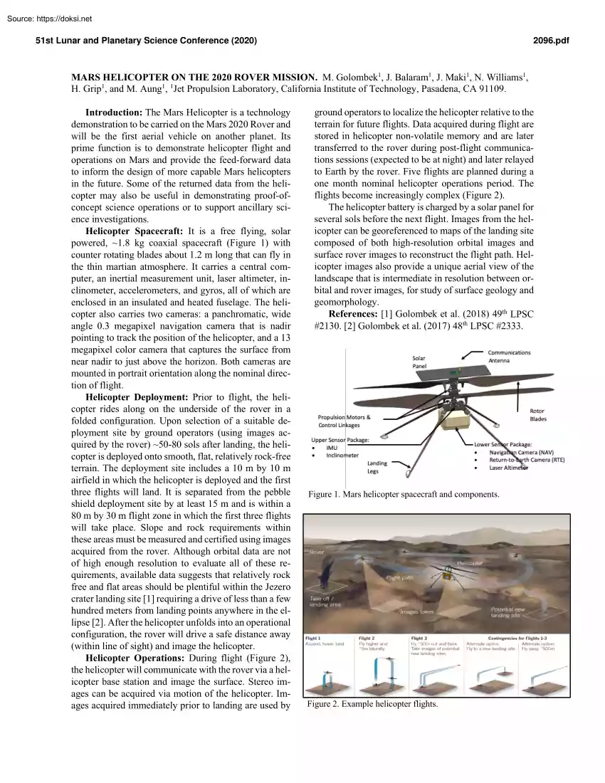
51st Lunar and Planetary Science Conference (2020) 2096.pdf MARS HELICOPTER ON THE 2020 ROVER MISSION. M Golombek1, J Balaram1, J Maki1, N Williams1, H. Grip1, and M Aung1, 1Jet Propulsion Laboratory, California Institute of Technology, Pasadena, CA 91109 Introduction: The Mars Helicopter is a technology demonstration to be carried on the Mars 2020 Rover and will be the first aerial vehicle on another planet. Its prime function is to demonstrate helicopter flight and operations on Mars and provide the feed-forward data to inform the design of more capable Mars helicopters in the future. Some of the returned data from the helicopter may also be useful in demonstrating proof-ofconcept science operations or to support ancillary science investigations Helicopter Spacecraft: It is a free flying, solar powered, ~1.8 kg coaxial spacecraft (Figure 1) with counter rotating blades about 1.2 m long that can fly in the thin martian atmosphere. It carries a central computer, an inertial
measurement unit, laser altimeter, inclinometer, accelerometers, and gyros, all of which are enclosed in an insulated and heated fuselage. The helicopter also carries two cameras: a panchromatic, wide angle 0.3 megapixel navigation camera that is nadir pointing to track the position of the helicopter, and a 13 megapixel color camera that captures the surface from near nadir to just above the horizon. Both cameras are mounted in portrait orientation along the nominal direction of flight. Helicopter Deployment: Prior to flight, the helicopter rides along on the underside of the rover in a folded configuration. Upon selection of a suitable deployment site by ground operators (using images acquired by the rover) ~50-80 sols after landing, the helicopter is deployed onto smooth, flat, relatively rock-free terrain. The deployment site includes a 10 m by 10 m airfield in which the helicopter is deployed and the first three flights will land. It is separated from the pebble shield deployment
site by at least 15 m and is within a 80 m by 30 m flight zone in which the first three flights will take place. Slope and rock requirements within these areas must be measured and certified using images acquired from the rover. Although orbital data are not of high enough resolution to evaluate all of these requirements, available data suggests that relatively rock free and flat areas should be plentiful within the Jezero crater landing site [1] requiring a drive of less than a few hundred meters from landing points anywhere in the ellipse [2]. After the helicopter unfolds into an operational configuration, the rover will drive a safe distance away (within line of sight) and image the helicopter. Helicopter Operations: During flight (Figure 2), the helicopter will communicate with the rover via a helicopter base station and image the surface. Stereo images can be acquired via motion of the helicopter Images acquired immediately prior to landing are used by ground operators to
localize the helicopter relative to the terrain for future flights. Data acquired during flight are stored in helicopter non-volatile memory and are later transferred to the rover during post-flight communications sessions (expected to be at night) and later relayed to Earth by the rover. Five flights are planned during a one month nominal helicopter operations period. The flights become increasingly complex (Figure 2). The helicopter battery is charged by a solar panel for several sols before the next flight. Images from the helicopter can be georeferenced to maps of the landing site composed of both high-resolution orbital images and surface rover images to reconstruct the flight path. Helicopter images also provide a unique aerial view of the landscape that is intermediate in resolution between orbital and rover images, for study of surface geology and geomorphology. References: [1] Golombek et al. (2018) 49th LPSC #2130. [2] Golombek et al (2017) 48th LPSC #2333 Figure 1. Mars
helicopter spacecraft and components Figure 2. Example helicopter flights
 1942. január 3-án, Pécsett született. A pécsi Janus Pannonius Tudományegyetem jogi karán szerezte diplomáját 1964-ben, majd 1965-ben, az Országos Széchényi Könyvtárban felsőfokú könyvtárosi oklevelet szerzett. [1][2][3]Saját elmondása szerint sohasem akart jogász lenni. Csupán azért jelentkezett a pécsi jogi karra, mert határozott elképzelés hiányában ez tűnt